Parrot Unveils 4G-connected Robotic UAV
Parrot has unveiled ANAFI Ai: a drone that sets new standards and capabilities for professionals. With a somewhat different appearance from most drones, it has insectile features. ANAFI Ai uses...
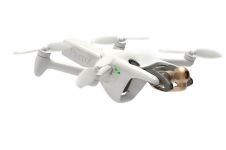
Parrot has unveiled ANAFI Ai: a drone that sets new standards and capabilities for professionals. With a somewhat different appearance from most drones, it has insectile features. ANAFI Ai uses...
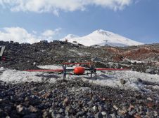
Mount Elbrus, with its peak of 5,642m, is the highest mountain in Europe. This makes it a remarkable attraction for adventurers, hikers and skiers from around the world, which calls...

AEE Aviation Technology, a global leader in electric aviation and camera technology, has announced the introduction of the Mach 4, a multiple payload capable commercial UAV built to provide a...
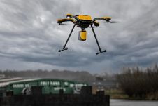
YellowScan has entered into a new product partnership with Acecore Technologies to offer the market a completely integrated Lidar-UAV solution configured to work together. YellowScan is a global leader and...

Calculating and reporting stockpile inventories is now easier and faster in the latest version of the Virtual Surveyor drone surveying software. Virtual Surveyor Version 8.2 enables users to accurately calculate...
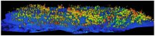
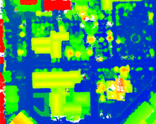
A forest fire site has been assessed using both high-resolution Lidar captured from a drone and satellite optical imagery to appraise the potential of this approach for the future. After...
DJI recently introduced the P4 multispectral, a high-precision unmanned aerial vehicle (UAV or ‘drone’) which exploits the integration of multispectral cameras to facilitate agricultural and environmental monitoring applications. Therefore, imagery...
In this case study, QuestUAV describes the use of UAV photography and photogrammetry to measure long-term erosion of the coast of northeast England. The British Geological Survey states that across...
An Aeromapper Talon UAV has flown a mission autonomously to a target located 30km away from the operators, while maintaining at all times a strong communications and control link. This...
This site uses cookies. By continuing to use this website, you agree to our Cookies Policy. Agree