Multiplatform Lidar Use in Digital City Projects
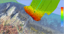
Following its emergence more than a decade ago, digital twin technology has developed to become a complex and comprehensive technical system that supports the construction of new smart cities. It...

Following its emergence more than a decade ago, digital twin technology has developed to become a complex and comprehensive technical system that supports the construction of new smart cities. It...
XOCEAN has completed 35 cable inspection surveys using a combination of uncrewed surface vessels (USVs) and uncrewed aerial vehicles (UAVs) between the Scottish mainland and Western Isles. There was a...
Teledyne Optech and Teledyne CARIS have united to form Teledyne Geospatial in response to evolving marketplace needs. Under the Teledyne Imaging group, the harmony between the two business units is...
CHC Navigation is expanding its reach throughout Europe and the world, with more dealers and customer support and advanced training and service points. The Shanghai-based company has been a player in...
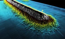
The Tonga Eruption Seabed Mapping Project (TESMaP) is a collaborative mission to discover the undersea impacts of the January 2022 eruption of the Hunga-Tonga Hunga-Ha’apai volcano. Using their collective knowledge,...
The EvoLogics Multibeam, a new multibeam echosounder option for the Sonobot 5 platform, was released at Ocean Business in Southampton, UK, in April this year. In May, EvoLogics conducted its final trials at one of the company’s regular testing sites the Plessower Lake in Brandenburg, Germany. The company is now taking the Sonobot 5 on a summer demonstration tour for partners and clients so that they can see its efficiency and effectiveness for underwater mapping for themselves. The EvoLogics Multibeam, a new multibeam echosounder option for the Sonobot 5 platform, was released at Ocean Business in Southampton, UK, in April this year. In May, EvoLogics conducted its...
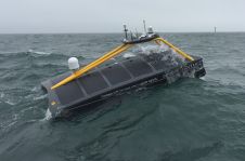
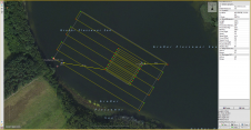
In a first for the offshore wind sector, a vessel remotely controlled from shore took to the sea off Suffolk (UK) over the weekend to undertake survey work for Greater...
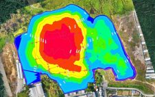
Hydrographic surveying in lakes and canal regions has not been an easy job in the past. Due to a lack of professional and portable surveying equipment and mobile platforms, the...
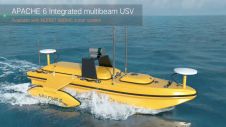
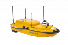
The APACHE6 unmanned surface vehicle (USV) is an innovative fully integrated solution for 3D bathymetric surveying, underwater object positioning, offshore construction, underwater archaeology and wreck rescues. Built around a triple-hulled...

Lidaretto is flexible and compact Lidar scanning system developed since 2015 and uniquely designed to be used the way that fits best to users’ specific application. You can easily mount...
This site uses cookies. By continuing to use this website, you agree to our Cookies Policy. Agree