World’s Densest Urban Aerial Lidar Dataset Released
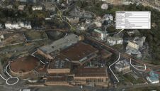
New York University’s Center for Urban Science and Progress (NYU CUSP) Professor Debra F. Laefer has released the world’s densest urban aerial laser scanning (Lidar) dataset. At over 300 points...

New York University’s Center for Urban Science and Progress (NYU CUSP) Professor Debra F. Laefer has released the world’s densest urban aerial laser scanning (Lidar) dataset. At over 300 points...

NCTech, the developer of reality imaging systems, has revealed a new 360-degree camera designed to be mounted on any vehicle in order to capture and generate virtual street-level imagery. Google...
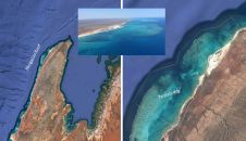
Airborne bathymetric Lidar is an ideal tool to study underwater features in the usually rather clear waters along the coast of Australia. Due to the remoteness of many of the...

Ron Roth of Leica Geosystems and Marcos Sirota of Sigma Space Corp explain how this technology will bring benefits through faster pulse rates and denser point clouds. Current airborne Lidar...
Leading organisations from across the geospatial industry, including Ordnance Survey, Google, HS2, Department of Transport, ARUP, Esri, AGI, and the RICS, will feature prominently in the GEO Business 2017 Conference...

The company BayesMap Solutions was established in October 2014 with the objective to provide unique consulting and software development services for the airborne Lidar industry. The main focus is data...

Diverse environmental effects, climatic changes and human alterations of the ecosystems are deeply changing Earth’s surface processes and creating environmental challenges that researchers are struggling to address. This article describes...

Current airborne Lidar systems, such as the Leica ALS series, capture one million points per second. Increasing the pulse repetition rate is the best way to achieve dense point clouds...

It is a well-known fact that African cities face a challenging future. With some 65% of urban populations living in slum conditions and 70% in informal work, they are also...
With location the common denominator, there are great opportunities ahead for surveyors, argues Ordnance Survey’s Simon Navin (above), if we realise the benefits for communities through interoperable data from Smart...
This site uses cookies. By continuing to use this website, you agree to our Cookies Policy. Agree