Usage of UAVs for flat roof drainage calculations
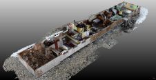
Modelling of urban areas, with emphasis on flat roof drainage calculations, is one application field in which the use of UAVs has significantly increased in recent years. A calibration base,...
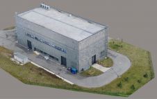
Modelling of urban areas, with emphasis on flat roof drainage calculations, is one application field in which the use of UAVs has significantly increased in recent years. A calibration base,...
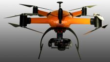
With the new release of the Condor V8-PPK mapping drone, Munich-based Videographics Ingenieurgesellschaft has completed its toolbox for most precise photogrammetric aerial mapping and surveying projects. The German company Videographics...
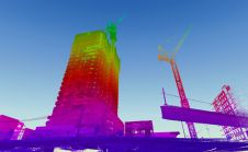
When it comes to 3D modelling for construction, what are the advantages and disadvantages of photogrammetry versus Lidar in terms of accuracy, complexity and cost? Breaking away from laser measurement...
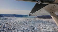
This aerial acquisition mission in Greenland was made all the more challenging by the unique Arctic location. Precise geodata is considered vital to support almost all aspects of community activities...
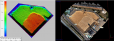
Research undertaken under a collaborative doctoral partnership between Historic England and the University of Reading, UK, is moving beyond the field of 3D data capture for digital preservation. It considers...
Terra Drone Australia, a group company of the worldwide industrial drone solution provider Terra Drone Corporation, has recently been engaged by Bunbury Fibre Exports to conduct a volumetric survey of...

UAV, aerial and satellite mapping service providers are competing for the global market – with a rising hunger – for geospatial insights. Automating the feature extraction process is key to...

senseFly, the Switzerland-based fixed-wing drones manufacturer, will showcase its range of UAV solutions and sensors at Intergeo in Stuttgart, Germany. The eBee X drone will be taking centre stage at...
Every two years, the photogrammetry and remote sensing community gathers at the ISPRS Geospatial Week. The event comprises a combination of workshops organized by various ISPRS Working Groups and other...

A pilot project conducted at a university campus in Curitiba, Brazil, aimed to create outdoor maps using UAS photogrammetry as well as indoor floor plans. At universities, facility managers and...
This site uses cookies. By continuing to use this website, you agree to our Cookies Policy. Agree