Found 143 results
Sort by

Laser Scanning and Archaeology

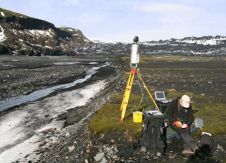
Terrestrial 3D laser scanning will become the future standard tool for high-resolution 3D documentation of archaeological excavations, but its capabilities are still underestimated by professional archaeologists and providers of scanners...

Read more

Cartography and GIS

The Second International Conference on Cartography and GIS took place in the Bulgarian ski resort of Borovets from 21st to 24th January 2008. The 130 participants from Europe, Africa and...

Read more

3D-Model of Siberian Fortress

Exploration and preservation of Por-Bajin fortress, testimony to the former presence of ancient civilisation in the wildness of Siberia, is one of the largest-scale projects in modern archaeology. Combining terrestrial...

Read more

APOLLO for Cyprus

Cyprus University of Technology has selected ERDAS APOLLO to manage and deliver its vector and raster data for several National Offices in Cyprus. GEOINFORMATION S.A., the distributor of ERDAS in...

Read more

Networks and Democracy

Digital heritage is a fast-moving field, with the nature of the technologies themselves dictating the culture of their usage and the type of people that can use them. These technologies...

Read more

Leica Geosystems Announces Software Additions

Leica Geosystems announces three new laser scanning software products for scan data import, forensic scene mapping and modelling complex 3D surfaces. These products – Cyclone Importer, ForensicMap Pro and 3DReshaper...

Read more

Predicting Rock Fall Hazards

The latest laser scanning and remote controlled aircraft technology are to be used to monitor glaciers where unstable slopes and rock falls are a continual threat. A Riegl LMS-Z620 long-range...

Read more

SuperGIS for Ethnology and Archaeology

Keio University, Japan, is to be using SuperGIS Desktop 3 and SuperPad 3 for the research in Ethnology and Archaeology. The procurement is contributed by BIZWORKS, SuperGeo's reseller in Japan....

Read more

Creative Minds and Clever Kit

Rapid developments in GIS technology and its applications, and thus growing demand for geospatial data, encouraged a group of friends including geodesists, IT people and foresters to create an innovative,...

Read more

New Life for Old Caves

Nottingham’s architectural heritage is enjoying a new lease of life thanks to a University project to survey almost 450 caves located below the UK City. The survey project is being...

Read more