Geo Connect Asia 2024 to unveil geospatial's transformative power
Geo Connect Asia (GCA) is set to return to the Sands Expo and Convention Centre in Singapore on 6 March and 7 March 2024. Since its establishment in 2019, GCA...

Geo Connect Asia (GCA) is set to return to the Sands Expo and Convention Centre in Singapore on 6 March and 7 March 2024. Since its establishment in 2019, GCA...
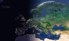
EuroGeographics is drawing attention to the indispensable role of official national geospatial data in enhancing Copernicus Services, particularly within land monitoring and emergency management. This highlights a reinforced partnership between...

An unprecedented scientific effort to Lidar-scan the entire surface of the Earth before it’s too late... that’s how Christopher Fisher, the founder of the Earth Archive, describes his initiative. He...
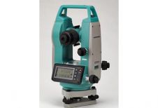
Sokkia is releasing a new digital theodolite series, the DT220, DT520, DT520A and DT620, with as a main distinguishing feature an improved power-saving technology. The DT620, recently set a world...

FARO Technologies has announced the acquisition of HoloBuilder and its leading photogrammetry-based 3D platform which delivers hardware-agnostic image capture, registration and viewing to the fast-growing digital twin market. FARO Technologies...

Maxar Technologies and blackshark.ai have collaborated to develop SYNTH3D, a synthetic 3D digital twin of the Earth's surface that is highly compatible and visually pleasing for use in gaming, simulation,...
Today’s digital revolution is leading to a huge amount of geospatial data. A digital twin is a digital, three-dimensional copy of a real-life environment – e.g. a city, building, railway...
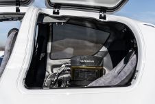
Diamond Aircraft and Vexcel Imaging have announced the next collaboration for a further expansion of Diamond’s special mission aircraft high-end sensor portfolio. The partnership will integrate the UltraCam Dragon 4.1...

Sven Cowan is NV5 Geospatial’s Programme Manager for Canada. He has over 20 years of experience in customer-facing positions within the geospatial information industry and has worked for multiple geospatial...

A topobathymetric Lidar survey was conducted to support flood preparedness in Canada. Which techniques achieved exceptional precision, and what were the logistical challenges? Find out more in this article. As...
This site uses cookies. By continuing to use this website, you agree to our Cookies Policy. Agree