Partnerships and people in the surveying community
Less than six months into her term of office, 'GIM International' spoke to Diane Dumashie, president of FIG (2023-2026), to hear about her experiences so far. Here, she shares her...

Less than six months into her term of office, 'GIM International' spoke to Diane Dumashie, president of FIG (2023-2026), to hear about her experiences so far. Here, she shares her...
Leica Geosystems, a part of Hexagon, has launched the brand-new Leica CountryMapper, its most efficient solution yet for large-area imaging and Lidar mapping. The company unveiled this latest expansion to...

Two initiatives aimed at encouraging young individuals to pursue a career in mapping and surveying are highlighted by Wim van Wegen in this column. He hopes that they will trigger other...
The European Association of Aerial Surveying Industries (EAASI) organized a webinar on 'Reducing the Carbon Footprint of Aerial Surveying' on 26 May 2023. This virtual event brought together industry experts...
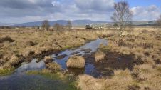
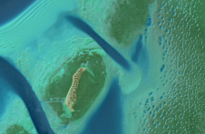
An annual airborne laser scan of the diverse landscapes in Scotland is being considered to monitor the health of the nation's forests, peatlands and natural ecosystems, according to a report...

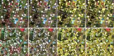
Claudio Persello is an adjunct professor at the Faculty of Geo-Information Science and Earth Observation (ITC) of the University of Twente. His main research interests are in the context of...
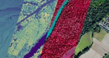
From drones and satellites to airborne-based sensors and Lidar, advances in remote sensing and geospatial information science are driving the development of innovative methods for data acquisition, processing and maintenance....

Darko Šiško is the assistant head of the City Office for Economy, Environmental Sustainability and Strategic Planning of the city of Zagreb, responsible for the strategic information and research sector....

The city of Zagreb has been developing a semantic 3D city model since 2008. The city spatial planning sector was recognized as the main project user and developer, while more...
A decade after completing its first shoreline mapping project, NV5 Geospatial has mapped over 10.5 million hectares of North America’s shoreline and riverine environments for more than 200 projects. These...
This site uses cookies. By continuing to use this website, you agree to our Cookies Policy. Agree