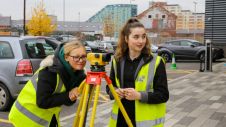
Training the future geospatial workforce
The coming years look promising for the geomatics sector, but the new generation of professionals must be prepared to face the challenges ahead. In view of the looming labour shortage...
The coming years look promising for the geomatics sector, but the new generation of professionals must be prepared to face the challenges ahead. In view of the looming labour shortage...

Guðmundur Valsson is a coordinator of geodesy and surveying at the National Land Survey of Iceland (NLSI). He gained a master’s degree in Geomatics from the Norwegian University of Life...
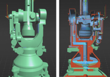
A recent project has celebrated 100 years of geodetic and photogrammetric innovation by 3D-digitizing an iconic WILD T2 theodolite from the 1927 series. An app has also been developed for...
Jing Sun is a PhD candidate in geodesy at the Department of Real Estate and Construction Management of the KTH Royal Institute of Technology, Stockholm, Sweden. Her research interests include...
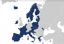
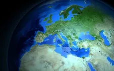
Users can now access the first free-to-use maps via the Open Maps For Europe online gateway. Four open datasets created using official national map, geospatial and land information from members...

Intergeo 2021 is returning as a physical event and will be held in Hannover from 21-23 September. There is a comprehensive safety strategy in place based on COVID-19 prevention rules;...
Katarína Pukanská is an associate professor at the Institute of Geodesy, Cartography and GIS, Technical University of Košice, Slovakia. Her research interests cover laser scanning and digital photogrammetry in creating...
Karol Bartoš is an assistant professor at the Institute of Geodesy, Cartography and GIS, Technical University of Košice, Slovakia. His research fields are digital photogrammetry technologies, terrestrial laser scanning and...
User requirements for authoritative geospatial data and support for policymakers were at the heart of discussions at EuroGeographics 2021 General Assembly. More than 100 leaders and senior representatives from 55 members...

Aleksandar Šašić Kežul is a project manager and airborne sensor operator at Flycom Technologies (FCT) with a master’s degree in Geodesy and Geoinformation from the Faculty of Civil and Geodetic...
This site uses cookies. By continuing to use this website, you agree to our Cookies Policy. Agree