Invitation to Participate in XXIV ISPRS Congress 2021
In view of the ongoing pandemic situation, ISPRS is organizing an extended digital edition of the XXIV Congress from 5-9 July this year, with all the features of an ISPRS...

In view of the ongoing pandemic situation, ISPRS is organizing an extended digital edition of the XXIV Congress from 5-9 July this year, with all the features of an ISPRS...
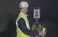
Trimble and Amberg Technologies have entered a collaboration to provide a tunnel survey solution. The combined hardware and software solution will enable construction, mining professionals and surveying service providers in...

A new INS from Oxford Technical Solutions aims to break new ground in bringing high-quality navigation data to the Lidar surveying industry. Launched on 22 March 2021, the xNAV650 promises...
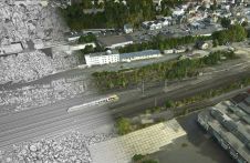
Is it possible to enhance point cloud accuracy and density by merging Lidar with photogrammetry technologies? Lidar data can penetrate trees and measure shadow areas to produce a very accurate...
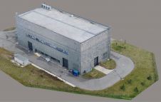
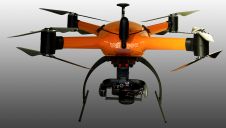
Modelling of urban areas, with emphasis on flat roof drainage calculations, is one application field in which the use of UAVs has significantly increased in recent years. A calibration base,...
The technique known as structure from motion (SfM) has been suggested as a valid alternative to traditional photogrammetric methods. In a project in Glasgow, UK, an RTK-based point-to-point validation technique...
What are the latest trends and technologies in aerial mapping, including hybrid systems of cameras with Lidar? The airborne market for wide-area 3D data acquisition is experiencing a noticeable trend towards...

SimActive has announced the release of Correlator3D version 8.6. The new version includes multiple new features, such as the use of intensity data from LAS files for image registration, the...
With the new release of the Condor V8-PPK mapping drone, Munich-based Videographics Ingenieurgesellschaft has completed its toolbox for most precise photogrammetric aerial mapping and surveying projects. The German company Videographics...

Gexcel confirms its leadership in indoor Mobile Mapping thanks to HERON® MS Twin, a device featured with a double LiDAR sensor and a high-resolution RGB panoramic camera. Enriched with a...
This site uses cookies. By continuing to use this website, you agree to our Cookies Policy. Agree