Lidar in surveying & mapping
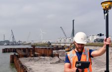
Lidar, short for Light Detection and Ranging surveying, represents a sophisticated measuring system leveraging the power of light. Widely recognized for its versatility, Lidar is extensively applied in diverse fields...
Lidar, short for Light Detection and Ranging surveying, represents a sophisticated measuring system leveraging the power of light. Widely recognized for its versatility, Lidar is extensively applied in diverse fields...
At GIM International, we are keen to gain an even deeper understanding of what really matters to our readers. What fuels your passion as a geospatial professional? What brings you...

Linda Foster oversees Esri’s worldwide strategic vision for land administration and surveying. With 20 years of experience working in the land and resource industry, she is a registered professional land...

There are indications that today’s technological advances are putting a fully operational multipurpose cadastre within reach, following decades of a global vision and small-scale progress towards a comprehensive map-centric land...

Intermap has won a US$20 million contract to map the Indonesian island of Sulawesi this year. The contract is the first phase of the Indonesian national topographic basemap programme to...
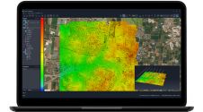
SimActive has unveiled the enhancement of Correlator3D for improved cloud environment productivity. With Correlator3D’s distributed processing capabilities, clients can seamlessly scale their processing in line with operational needs. The challenges...
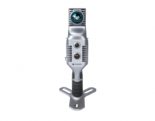
Stonex has launched a new SLAM solution for fast and efficient large-area surveys: the X70GO SLAM laser scanner. It combines mobile scanning with a stationary mode to scan with higher...

Stonex is an Italian company, world leader in measurement and surveying. The head office is near Milan and the American headquarters is in Concord, USA. The company also has a...

Founded in 2017, ZZCOMM technology of geospatial hardware and software solutions provides rapid and high-accurate geospatial data for BIM, mining AEC, survey and mapping industries, whether they are indoor, outdoor,...
Calling all professionals! Please contribute to the 2024 edition of the annual geospatial industry survey by GIM International, which is currently in progress. This yearly tradition serves as a valuable...
This site uses cookies. By continuing to use this website, you agree to our Cookies Policy. Agree