Juan Partida
Juan Partida is CFO of the government of Jalisco, having been a public servant for the last 15 years. From the outset, his involvements have included modernizing and designing cadastral...

Juan Partida is CFO of the government of Jalisco, having been a public servant for the last 15 years. From the outset, his involvements have included modernizing and designing cadastral...
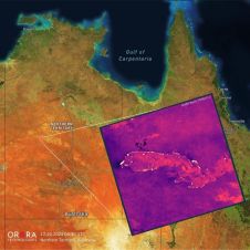
UP42 and OroraTech have signed a partnership agreement to grant easy and fast access to global high-resolution thermal-infrared imagery. UP42 is a geospatial developer platform and marketplace, and OroraTech is...
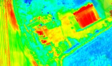
Topodrone has recently unveiled a cutting-edge drone thermal mapping solution: the Topodrone PT61 camera, designed to conduct detailed surveys and generate thermal orthomosaic maps, facilitating the creation of accurate 3D...
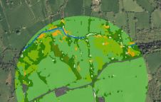
The UK’s Peak District National Park Authority is pioneering the use of artificial intelligence (AI) to automate the production of highly detailed land cover maps, in a project in partnership...
Cadastre & Land Administration Geospatial data obviously is key to sustainable land management. But what are the common success factors for land administration and cadastral systems around the world? In this issue, we will...

Both vertical and oblique aerial images have their own advantages, making them valuable in different reality mapping applications. So how can you choose between the two? This comparison will help...

Anna Jarvis is Trimble Applanix’s land mobile mapping product manager, focused on product development for the industry. After graduating with a master’s degree in Geomatics Engineering from the University of...

In a high-flying endeavour spanning over six decades, the UK’s National Grid's fleet of advanced helicopters have been diligently patrolling pylons and power lines, ensuring the health and reliability of...
Whenever new objects have to be created, be it on or below the land and water, construction plays a role. The construction process often starts with surveying, either [marine surveying]...

In the rapidly evolving landscape of geospatial technology, the annual Trimble Dimensions gathering is a dependable beacon for the surveying and mapping fields, providing a panoramic view of the current...
This site uses cookies. By continuing to use this website, you agree to our Cookies Policy. Agree