A Spatial Turn in History
Geography and history are sister disciplines. In fact, geography as a field of scientific research evolved from the study of history. Whereas geographers have the perspective of space, historians consider...
Geography and history are sister disciplines. In fact, geography as a field of scientific research evolved from the study of history. Whereas geographers have the perspective of space, historians consider...
This article presents a first overview of the legal issues involved in geospatial data-gathering in space. Matters of security and privacy must be resolved within a legal framework if satellite...
Intergraph Mapping and Geospatial Solutions (AL, USA) has announced GeoMedia Grid 5.2 is now shipping worldwide. GeoMedia Grid provides integration of vector and grid data formats for viewing and analysis....
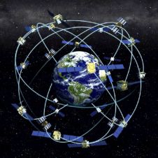
Receiver position is calculated from the position of satellites and the distances to them. Distance is calculated from the time a radio signal travels between satellite and receiver. But how...
The 4th International Symposium on Digital Earth (ISDE) was held in Tokyo, Japan from 28th to 31st March 2005 with the theme ‘Digital Earth as Global Commons’. The more than...
The internet has created tremendous potential for the dissemination of geo-information for decision making. Scalable Vector Graphics (SVG) is an Open Source technology that can be efficiently used by the...
The American Society for Photogrammetry and Remote Sensing (ASPRS) has launched the ASPRS Foundation, Inc., an independently registered entity that will raise, invest, and grant funds to the ASPRS Awards...
RADARSAT-2, Canada’s second Synthetic Aperture Radar (SAR) Earth observation satellite will offer users imaging flexibility and increased data information content, ensuring continuity of all existing RADARSAT-1 beam modes along with...
Writing a text or revising a spreadsheet and saving it...editing a map or digital photo and saving it…a seemingly unlimited amount of data, all stored inside the computer on the...
The X Conference of the Iberoamerican Society of Geographic Information Systems (XIBCGIS) will take place in the San Juan City (Puerto Rico) on 6 to 9 September 2005. The organisation...
This site uses cookies. By continuing to use this website, you agree to our Cookies Policy. Agree