Maps Charting Demographics of the Oil Spill Region
A multidisciplinary group of LSU researchers has developed a series of maps charting the population demographics of the region surrounding the oil spill in the Gulf of Mexico. The maps...

A multidisciplinary group of LSU researchers has developed a series of maps charting the population demographics of the region surrounding the oil spill in the Gulf of Mexico. The maps...
Adverse weather and terrain conditions meant the Cano-Limon oil pipeline in Colombia had never been accurately mapped until orthorectified images and digital elevation models covering an area of 94,000km2 were...
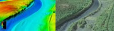
The US Geological Survey (USGS) and Dewberry have jointly released a new topobathymetric Lidar dataset for the Potomac River, extending from the Potomac Highlands in West Virginia to the Chesapeake...

Between August and November 2009 as requested by Lukoil-Nizhnevolzhskneft, ScanEx Research and Development Center completed the project for satellite monitoring of oil pollution in the North Caspian region. The project...
Spatial Energy has EhsWatch, an Environmental, Health, Safety and Security Monitoring program for oil and gas operations. Offered as a subscription service from Spatial Energy, EhsWatch is a turn-key programme...

By using the Earth’s magnetic field, combined with new innovative technology, oil and gas drilling companies are increasing oilfield productivity while reducing development costs and environmental impacts. An article in...
Ecopetrol, the national oil company in Colombia, has obtained an Esri enterprise license agreement (ELA) to support its extensive operations. The ELA software programme simplifies procurement of essential ArcGIS technology...
This site uses cookies. By continuing to use this website, you agree to our Cookies Policy. Agree