CHC Navigation
CHC Navigation is expanding its reach throughout Europe and the world, with more dealers and customer support and advanced training and service points. The Shanghai-based company has been a player in...
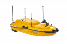
CHC Navigation is expanding its reach throughout Europe and the world, with more dealers and customer support and advanced training and service points. The Shanghai-based company has been a player in...
Airbus has released an online interface that allows customers to directly task the radar satellites and access the comprehensive 15-year radar archive. In late June, users will also be able...
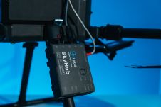
SPH Engineering has announced the third generation of the UgCS SkyHub hardware and released the largest update of the UgCS SkyHub software ever. The development accumulates five years of knowledge...

In this interview, Rudolf Staiger, president of FIG, shares his thoughts on the geospatial industry, including market trends, technology drivers and challenges, and the impacts of COVID-19 and climate change....

Airbus and Japanese geospatial solutions provider PASCO have signed a new partnership agreement for a Pléiades Neo Direct Receiving Station (DRS) with associated data distribution rights on the Japanese market....

Powerhouses of photogrammetry and remote sensing science and industry are set to gather in Nice, France, for the XXIV Congress of the International Society for Photogrammetry and Remote Sensing (ISPRS) from 6-11 June 2022. Powerhouses of photogrammetry and remote sensing science and industry are set to gather in Nice, France, for the XXIV Congress of the International Society for Photogrammetry and Remote Sensing (ISPRS)...

Mhamad El Hage is a senior scientist in remote sensing and GIS, specialized in 3D modelling of topography using optical and radar imagery. He is the director of the Faculty...

Laurent Polidori is a senior scientist in remote sensing and geodetic sciences, with experience in radar remote sensing and cartographic applications. He is an associate professor at UFPA (Belém, Brazil)....
Intermap Technologies has signed a new Master Services Agreement with Dewberry under its recently awarded U.S. Geological Survey (USGS) Geospatial Products and Services (GPSC4) prime contract. Intermap – a global leader...
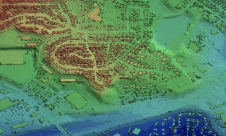
"There are not many above-ground structures that aren’t captured, accounted for and on view to the public online. So why isn’t this true for what’s below the surface too?" ask...
This site uses cookies. By continuing to use this website, you agree to our Cookies Policy. Agree