GeoEye-1 Satellite Imagery for Google
GeoEye has started delivering high-resolution, colour satellite imagery from its newest satellite to Google. The GeoEye-1 satellite images that are being highlighted by Google were all taken within the last...

GeoEye has started delivering high-resolution, colour satellite imagery from its newest satellite to Google. The GeoEye-1 satellite images that are being highlighted by Google were all taken within the last...
GeoEye has finalised a Service Level Agreement (SLA) modification to the company\'s existing NextView contract with the National Geospatial-Intelligence Agency (NGA). The value of the SLA is USD12.5 million per...

DigitalGlobe has provided NBC's "TODAY" show with access to its extensive library of advanced satellite imagery and to its 3D ImageScape product for the second edition of the "Today Goes...
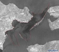
ScanEx Center (Russia) has received and processed Radarsat-1 satellite imagery of the wreck site in the Kerch Strait where on 11th November stormy wind (up to 32 m/sec) and sea...
Healing Hands International (HHI), a non-profit humanitarian organisation, is working with the Native Communities Development Corporation (NCDC), a DigitalGlobe business partner, to obtain satellite imagery from DigitalGlobe for use in...
DigitalGlobe’s European business partner, Italy-based Eurimage, has entered into a contract with the European Commission (EC)’s Joint Research Center to supply worldwide satellite imagery over a four-year period. The DigitalGlobe...
The present product survey provides the main characteristics of today’s high-resolution imagery acquired from orbiting platforms. A clear trend is the ongoing improvement of pixel size, also called Ground Sample...
UP42 and SI Imaging Services (SIIS) of Daejeon, South Korea, have signed an agreement to make imagery from the Kompsat satellites available on the UP42 marketplace and developer platform. The...

The 'Reef Support' startup formed by six TU Delft students has been named overall winner of the Copernicus Masters international innovation competition with an idea to combat the worldwide decline of...
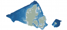
Through the collaborative implementation of satellite-derived bathymetry (SDB), the Danish Geodata Agency and EOMAP are synergizing efforts to contribute to the European Marine Observation and Data Network (EMODnet) Bathymetry partnership....
This site uses cookies. By continuing to use this website, you agree to our Cookies Policy. Agree