Geoinformation Software as a Service
Accurate geoinformation about urban areas, public buildings or historical sites is in great demand. It has become astonishingly easy to capture these scenes through cameras or laser scanning or to...

Accurate geoinformation about urban areas, public buildings or historical sites is in great demand. It has become astonishingly easy to capture these scenes through cameras or laser scanning or to...
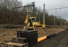
Advanced total station solutions from Topcon Positioning were chosen to support a project to renew the railway switches and crossings at a site in Belgium. By providing accurate real-time data, the...

Aerial surveying offers diverse career opportunities. How are trends in the evolving landscape of geomatics studies affecting graduates' skills, and what could this mean for the future of the industry?...
Sanborn has selected SimActive Correlator3D as its new platform of choice. With immense data volumes traversing complex production workflows, Sanborn required a new photogrammetry suite for handling projects efficiently. "The...
Golden Software has launched the Golden Software Blog which is a resource for technical tips, answers to frequently asked questions, and announcements. The blog will have tagged keywords to facilitate...
ERDAS has released ERDAS 2011 Software, including ERDAS IMAGINE, LPS, ERDAS APOLLO, ERDAS Extensions for ArcGIS 10 and other leading desktop and server products. Portfolio-wide changes for the ERDAS 2011...
The Optech Lidar Mapping Suite (LMS) version 2.0, for Airborne Laser Terrain Mapper (ALTM) clients, has been released. The suite offers a new workflow designed for the production environment. Incorporating...
Pythagoras BVBA will take over all business activities of ADW Software BVBA from 1st January 2011. Pythagoras BVBA is formed by two employees of ADW Software BVBA, Jan Van Looy,...
This site uses cookies. By continuing to use this website, you agree to our Cookies Policy. Agree