Bread and Butter for the Surveyor
The future for the surveying professional is bright. This is one of my favourite adages, and one I have expressed in a variety of wordings many times over in the...
The future for the surveying professional is bright. This is one of my favourite adages, and one I have expressed in a variety of wordings many times over in the...

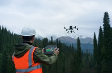
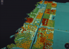
The new state-of-the-art Phase One P5 128MP camera has been seamlessly integrated into Quantum Systems’ flagship Trinity Pro mapping drone and the leading surveying workflow, Trimble Business Center. The resulting purpose-built,...
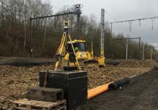
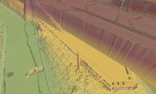
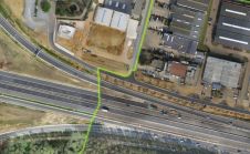
Advanced total station solutions from Topcon Positioning were chosen to support a project to renew the railway switches and crossings at a site in Belgium. By providing accurate real-time data, the...

Prague recently served as the testing ground for the integration of Mosaic’s 360-degree camera system with SmartDelta’s mobile mapping software. Known for its rich history and stunning architecture, the city...
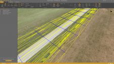
Virtual Surveyor has unveiled Terrain Lenses in Version 6.3 of its drone surveying and mapping software. Overlaid on a Lidar point cloud or orthophoto, the six lenses enhance different aspects...
DJI selected Intergeo in Berlin as the stage for unveiling the DJI Zenmuse L2. This highly integrated Lidar system builds on the success of DJI’s Zenmuse L1 to bring new...
Lidar developer and manufacturer YellowScan and drone manufacturer DeltaQuad have announced a renewed partnership aimed at delivering high-quality 3D mapping data to professionals worldwide. The collaboration involves the integration of...

Canada's geospatial community is gearing up for the country's inaugural national geospatial exposition. The GoGeomatics Expo is scheduled to take place from 6-8 November at the iconic Calgary Stampede grounds....
Virtual Surveyor drone surveying and mapping software has added functionality that enables users to process larger projects without buying more powerful computers or expensive cloud services. The enhancement is among...
The UAV surveying software Virtual Surveyor has eliminated the need for clients to use third-party applications to prepare data for processing. Newly released Virtual Surveyor 6.1 now handles on-the-fly projections...
This site uses cookies. By continuing to use this website, you agree to our Cookies Policy. Agree