Building a Global 3D Routing Map
Mapping company HERE, co-owned by German automotive companies Audi, BMW, and Daimler, uses a fleet of more than 200 cars to collect dense point cloud data about roads around the wo...
During the GIM International Summit, participants approached location and time-related issues to explore the needs and demands, both within the geospatial sector and beyond. Other workshops:
Building geoICT infrastructures is really about creating networks and ground rules. However, these are a subset of information infrastructures rather than an end in themselves. Infrastructures are certainly not only about technology and standards, public versus private or even top-down versus bottom-up. The focus should be on linking real societal problems with the users and the services they require.


Mapping company HERE, co-owned by German automotive companies Audi, BMW, and Daimler, uses a fleet of more than 200 cars to collect dense point cloud data about roads around the wo...

After a surprisingly lengthy delay, the geocommunity has caught on to the advantages of 3D visualisation; this technology has become a real hype in recent years. However, desp...

Maps have always been important for communicating geographic information to their users. However, although cartographers in the past may have conducted research into how people wor...
Apart from being a prerequisite for a functioning market economy, environmental action and secure livelihoods, land administration systems create invaluable base data for all spati...

High-tech startup NavVis, specialised in the digitalisation of indoor spaces, has announced that it has successfully closed its latest funding round of EUR7.5 million. Target Partn...
Today, Lidar and photogrammetry enable the collection of massive point clouds. Faced with hundreds of billions or even trillions of points, the traditional solutions for handling p...
The race between data production and processing capacity has been going on for many decades, with data production usually on the winning team. This is also true for airborne and sp...

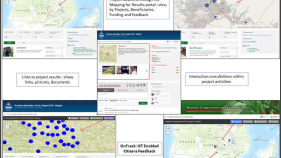
Geographic information and communication technologies (or ‘Geo-ICT') are important for land governance. While many challenges the world faces today rely on good land governan...
Follow GIM International on Facebook, LinkedIn, Twitter or sign up for the newsletter! Don't miss the latest developments: join GIM International!
 |  |  |  |
| 29.769 SUBSCRIBERS | 22.513 MEMBERS | 9.484 LIKES | 8.739 FOLLOWERS |
This site uses cookies. By continuing to use this website, you agree to our Cookies Policy. Agree