GIS for Hydrological Modelling
Estimating rainfall discharge is difficult in large catchment areas with varying topography. This leads to widespread inadequacy in culvert design, with resultant damage to these and other drainage in...
Cartography is about describing the world in the form of maps and diagrams. Classic cartography produces paper maps but nowadays this field also encompasses Geographical Information Systems and the products produced by these systems. Cartography is heavily dependent on data from Remote sensing and Land surveying and topography for the dry part of our world and marine surveying and bathymetry for the wet parts of our world.
Cartography / GIS can be found in almost any industry vertical where it transforms the various data sources into products readily useable in for example land and water management, climate and farming and conservation.
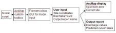
Estimating rainfall discharge is difficult in large catchment areas with varying topography. This leads to widespread inadequacy in culvert design, with resultant damage to these and other drainage in...

Generalising about Africa is dangerous. With 47 countries (or 53 if you use the UN list and include island nations such as Cape Verde, Madagascar and the Comoros), it is hugely diverse. The state of e...

Last month, while travelling from Konstanz, a town in the south of Germany, to Memmingen airport, I engaged in a conversation with a fellow train passenger. After discussing the German football team�...
The next phase in GIS development on the internet should restore user freedom and give a fully comprehensive overview of geo-objects originating anywhere and containing all relevant information. It sh...

The mantra that “data is king” was instilled into me when I was a relatively new (and young) surveyor. Nowadays data is still a prime focus, but its volume is such that “big data” is now consi...

In this article, we speak to Paul Ramsey about how both PostgreSQL and PostGIS can provide a solid foundation for any small to large organisational GIS architecture. Paul, a Solutions Engineer at Cart...

Need to update your skills? Want to learn a new GIS? Adena Schutzberg has sound advice for those turning to the online world to learn new skills. The topic of this issue’s column comes from an email...

The most common use of GIS is as a historian’s tool, to describe a situation over time. In this, its value reflects the currency, quality and accessibility of the input data. These factors have gene...
Response time is key to fire fighting. Urbanisation and changes in land use demand continual assessment of the spatial distribution of fire stations and fire risk within the framework of costs/benefit...

Few people think about how time relates to location and spatial awareness. Tools for measuring time and space form the foundation of geography and are critical to connecting people to the land they us...

This paper implemented Geographic Information System (GIS) technology to explore the settlement patterns of ethnic groups in Nan, Thailand, in relation to geographic factors. The general findings reve...
GIS is a very useful tool in the planning of urban conservation. GIS includes integration of vector and raster data, geographical referencing, correction and spatial adjustment. GIS analysis tools and...

The Vercator toolkit offers a ground-breaking approach to generating survey data for a BIM process. Produced by a UCL spin-out company, Correvate, this article touches on the robust automatic registra...
I moderated a panel on GIS careers recently. All six of the panelists, representatives from both academia and industry, agreed that everyone in the field should be able to program and use the concepts...

On 13 March, Esri and Willis Towers Watson, insurance advisors and brokers, hosted a seminar on GIS and insurance at the Willis Tower in the City of London. This was the second such event, with a two-...
This site uses cookies. By continuing to use this website, you agree to our Cookies Policy. Agree