
“Think big for coastal mapping” is the foremost advice that Don Ventura of Teledyne Geospatial would impress upon agencies interested in bathymetric Lidar. “It’s a matter of efficiency of scale.” Airborne bathymetric Lidar can actually be more efficient and cost less per square kilometre than acoustic methods in nearshore, optically-suitable waters. Data collection with airborne bathymetric Lidar is 20 to 30 times faster than with a survey vessel using acoustic technologies. It is not unreasonable to expect to survey 50 to 100 square kilometres per day, whereas covering a similar area by boat could take considerably longer. Another advantage of thinking big is added flexibility: surveyors can adjust operations to current environmental conditions, especially with a much faster aircraft platform. If local conditions prove unsuitable, and with all survey plans loaded into the system, it’s possible to switch to another area entirely, which might be a couple of hundred kilometres away. This dramatically increases the likelihood of coming back with a dataset you can use every time you take off.
CZMIL Supernova: A Next-generation Bathymetric Lidar System
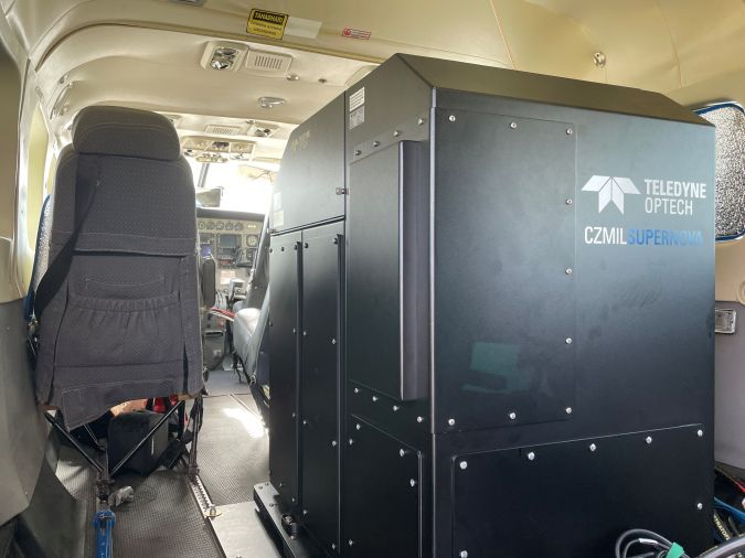
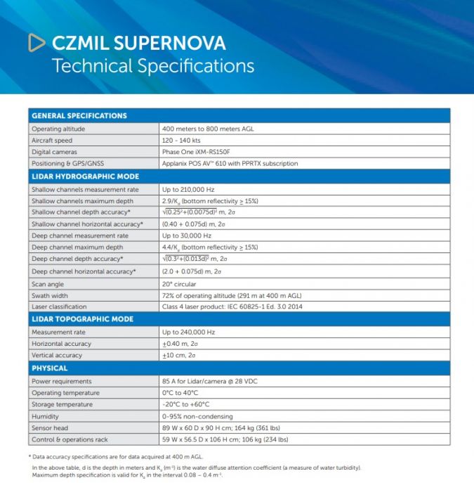
Teledyne Geospatial is a pacesetter in hardware and data processing software for airborne bathymetric Lidar. In June 2021, it launched its ground-breaking CZMIL Supernova system, or Coastal Zone Mapping and Imaging Lidar. The CZMIL Supernova is ideally suited for topographies such as inland waterways, coastal beaches, coral reefs and other shallow-water marine environments. With the most powerful green laser available on the commercial market, it offers maximal depth penetration (4.4 /Kd[1] for the ‘deep channel’ receiver and 2.9 /Kd for the ‘shallow channel’ receivers). According to Ventura, one substantial benefit of such a powerful bathymetric Lidar system is how much more reliable the system performs in less-than-optimal conditions. “People are now understanding the value of having a system capable of not only greater depth penetration compared to other systems on the market but also the ability to combat turbidity in waters where it would otherwise prove difficult to obtain consistent survey coverage using other topo-bathy LIDARs”, says Ventura.
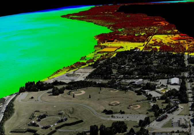
Next to superior coverage in turbid waters, the CZMIL Supernova has up to three times the point density of its predecessor. Its full waveform capture of land and water opens the door to other uses of the data beyond elevation and depth, such as object detection, water clarity assessments, reflectance imagery of the sea or lakebed, orthomosaics, DEMs/DTMs, etc. This means that once the cartographers have satisfied their requirements, a range of other marine users can also benefit from the Lidar data.
Expanding Applications of Topo-bathy Lidar
“Through experience and wider stakeholder outreach, more opportunities are appearing”, says Ventura. “The market is still relatively young because many agencies that typically aren’t mapping as their principal activity could still benefit from access to bathy Lidar data.” Their main responsibility might be coastal zone management or resiliency, for example. Key phrases you hear today – protecting and understanding the environment, change detection, sea level rise, flood inundation modelling – all require shallow water data and details on the land-sea interface.
Many national hydrographic agencies are now incorporating specific passages about bathymetric Lidar in their tenders, according to Ventura. “We’re seeing the inboard edge of the area of interest being drawn on land because they know the systems can collect topographic as well as bathymetric data. That’s something we are keen to promote.”
Ventura also notes that the industry in the past has been guilty of not promoting the base products that can be generated from a survey other than the point cloud. “With topo-bathy Lidar, you also have full waveform returns from the seabed. That means, similar to multibeam backscatter or sidescan interferometry, you can generate reflectance imagery and identify the nature and form of the seabed as it changes.” From there, Ventura says, you can ground-truth the generated imagery and then create seabed classification maps and such.
CZMIL Supernova incorporates a high-resolution PhaseOne camera that can be used for Lidar data QA and creating mosaic imagery. So, in addition to the LIDAR data, these systems provide excellent RGB and sometimes multispectral imagery for the survey area. “It’s all done at the same time, georectified, orthorectified, and at centimetric resolution.” CZMIL Supernova’s optional hyperspectral camera, the ITRES CASI 1500, allows the surveyor to also collect hyperspectral information in the survey area.
Industry Forerunners
One company with a head start in the use of the CZMIL Supernova is Terratec, a leading Norwegian mapping company. Terratec was the first private service provider to acquire the CZMIL Supernova. It has deployed the system on a range of projects, including marine coastal zone base maps and mapping Scandinavia’s arctic lakes. In 2022, they added surveys around the Baltic region and Eire’s west coast and continue to explore other international opportunities.
In July 2022, Terratec mobilized the CZMIL Supernova in Catalonia, Spain, to survey approximately 300 square km of the Mediterranean coast. The aim is to update the coastline to get a better indication of local changes and sea level rise. As is often the case, there is a need to fill the existing data gap between where traditional hydrographic surveying ends and terrestrial mapping begins. Topo-bathy Lidar is an ideal tool for this. Other regions where topo-bathy Lidar has or is being utilized, with new projects expected, include the Caribbean, Pacific island and archipelagic states, Middle East region (especially the Red Sea area), South America, Australasia, and other Mediterranean countries.
Flexibility to Overcome Environmental Challenges
Each different environment brings particular challenges and opportunities, impacting the feasibility and planning of bathymetric Lidar work. Tidal variations and turbidity are major factors that planners can play with to their advantage. To maximize the coverage of bathymetric Lidar, surveyors can use tactics such as leveraging big tidal ranges and conducting surveys at low water or following a period of neaps with less sediment transfer and transport.
“We have new clients using their systems in different environments: freshwater lakes in Sweden, inland waterways in Florida, the open-ocean west coast of Ireland, and now also in the Mediterranean”, says Ventura. This is in addition to other well-established programmes in Australia, the United States and Canada. “We always go on about the depth capability of these systems, but really, the focus today is very much on the coastline. I see Lidar as another tool in the box: it is an augmentation to the arsenal of tools available to the modern hydrographic surveyor and something that should be contemplated, especially for surveys where some of the areas are tricky. That might mean they are hazardous for manned vessels, very shallow, or very dynamic tidally, where you’re restricted a lot of the time by literally the amount of water that you’ve got.”
A major focus is to tie the bathymetric data with changes on land and in the nearshore area. Topo-bathy LIDAR can give surveyors that seamless join that has long eluded geographers. “It’s a zipper between the two big datasets, the hydro and the topo”, says Ventura.
Teledyne Geospatial is part of Teledyne Imaging, a group of leading-edge technology companies united under the Teledyne umbrella. Teledyne Geospatial is made up of Teledyne Optech and Teledyne Caris. Don Ventura is the product manager for bathymetric Lidar.