
A Water Information System Tailored for Users
Supporting Sustainable Water Management in Lake Naivasha Basin, Kenya
In 2009 Kenya was hit by a severe drought which reduced the available water resources, thus impacting citizens and industry alike. In particular, Lake Naivasha receded to its lowest level in 75 years. The area around the lake had seen steady growth of the population and the flower industry, increasing the burden on the water resources. To address the situation a combined effort by the government, civil society and the private sector was launched which resulted in the Integrated Water Resource Action Plan Programme. Modern geospatial technologies and open-source software allow efficient system development to support the implementation of this programme.
For many years, water resources in the Lake Naivasha Basin have been monitored by collecting, processing, managing and disseminating water information using conventional tools including printed forms, spreadsheets and desktop GIS applications. This approach is very prone to errors, results in lengthy workflows and, most importantly, limits the options for data exploitation by stakeholders.
Status of Water Resources
The Integrated Water Resource Action Plan Programme (IWRAP) aims at creating essential enabling conditions for effective water regulation and governance, sustainable land and natural resource use and sustainable development in the Lake Naivasha Basin. To create the appropriate conditions for monitoring the water resources, a modern, web-based system water information system has been developed called MAJI-SYS (Maji is the Swahili word for ‘water’) built entirely on open-source software. The system gives stakeholders insight into the status of water resources in the basin in near real time, and for the staff of the Water Resource Management Authority (WRMA) the system supports storage, processing and analysis of data in an efficient and contemporary manner. MAJI-SYS is one of the deliverables of IWRAP, which focuses on supporting information management and dissemination of information about the water resources in and around the Lake Naivasha Basin.
Stakeholders needs
Monitoring of water resources in the lake basin is the responsibility of the Naivasha sub-regional office of WRMA. To keep stakeholders up to date about the water resources situation, the MAJI-SYS was developed based on an in-depth analysis of existing operational workflows. This analysis focused on understanding the internal workflows for the provision of services to stakeholders, identifying the key datasets manipulated in these workflows, and determining the necessary approach to modernise the existing systems.
Workflows
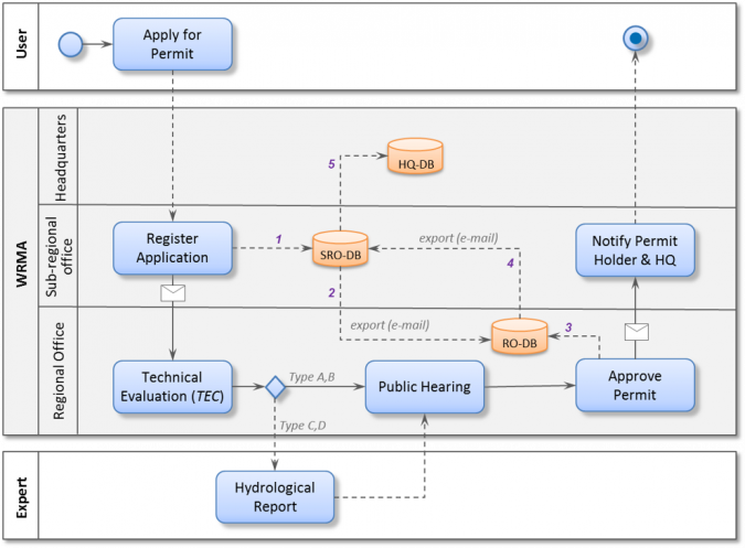
Figure 1 shows a model of one of the studied workflows, depicting the relationships between the various hierarchical levels of WRMA. The figure also shows the existence of three data repositories, one at each level. Interestingly, these three repositories hold mostly the same data but in different formats. This includes spreadsheets and binary transfer formats at the level of sub-regional offices, and in proprietary database format at the headquarters. One of the many difficulties here is that the sub-regional offices lack the software to access some of those formats resulting in them collecting the data but being unable to perform any analysis.
Functionality
Based on the analysis, the users and functionality of MAJI-SYS were defined. MAJI-SYS focuses primarily on addressing the needs of the different users. Field officers can collect and store observations of, for example, hydrological variables. Water resource managers can build a picture of the current condition of the basin by analysing data from the multiple observed hydrological variables. Water users can see allocated volumes and their relationship with the conditions of the basin. As such the information provided by MAJI-SYS centres on:
1) Monitoring the quantity and quality of water resources in the basin
2) Assessing the long-term impact on the basin based on different policy options and water allocation scenarios
3) Informing stakeholders and the general public about the actual status of the water resources.
Architectural Design
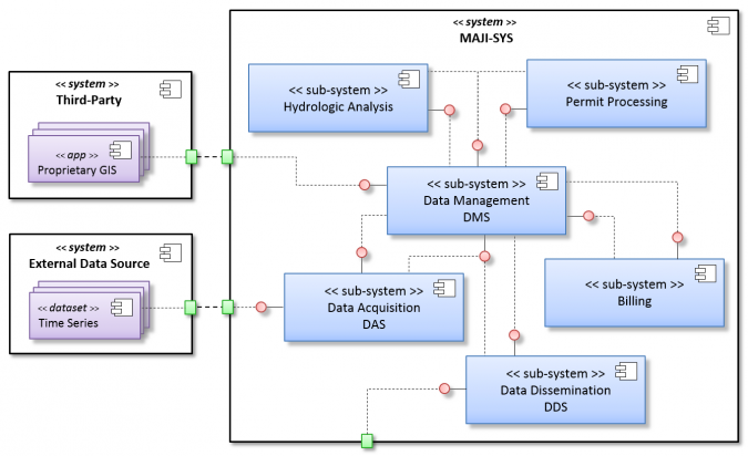
The architecture of MAJI-SYS is designed to facilitate the consumption of data resources, use of software tools and dissemination of data products via compliant service interfaces. Intrinsic to the working environments is that these services can be created, delivered, governed and maintained by different parties. To achieve this MAJI-SYS uses a layered architecture, where a layer is defined as a very coarse-grained group of components put together to address one specific concern of the system. Components within a sub-system collaborate and deliver value to components in other layers or may also consume services from these layers. Components connect, interact and exchange messages by using standardised interfaces. This characteristic also makes it possible for MAJI-SYS to assimilate and accommodate changes in components or to incorporate new ones that might occur, for example, as a result of technology life cycles, such as new software versions. This component-based approach substantially simplifies the maintenance of the system, which is a condition for implementation. Figure 2 shows the high-level architecture of MAJI-SYS including each of the sub-systems with a specific role.
Data Acquisition
The Data Acquisition Sub-system provides the interfaces to support the various time-series data acquisition and editing methods (quality control of field-collected data) for the monitoring data. This includes field data collection using smartphones, manual data entry through web forms, and import forms. Import forms allow data to be loaded from bulk files or telemetric stations. Bulk files result from loggers attached to monitoring stations. Although the loggers record observations periodically, e.g. every two hours, the data is uploaded to MAJI-SYS only once or twice a month. Telemetric stations send data directly to MAJI-SYS via the internet or 3G networks.
Data Processing
The Hydrologic Analysis Sub-system encapsulates the processing functions of MAJI-SYS. These functions are used in analysis, planning, reporting, mapping and modelling tasks; to understand water resource availability holistically through integrated views of diverse data sources; and to provide the basis for water allocation and permitting.
Data Dissemination
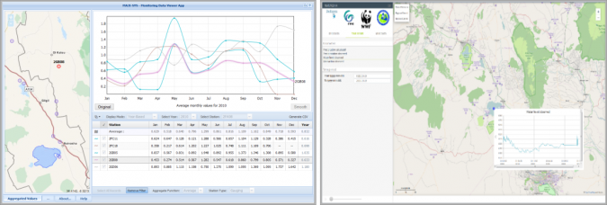
The Data Dissemination Sub-system (DDS) deals with the provision of services to stakeholders or other systems. The dissemination options include: standardised OGC services that can be used via Application Programming Interfaces (APIs) to obtain maps, time series, etc.; a viewer to enable non-expert users to visualise the status of water resources, permit information (e.g. status, validity), etc.; and an analysis tool allowing users to experiment with the data to generate customised products and visualisations. Figure 3 shows snapshots of the DDS interfaces.
Development
MAJI-SYS has been developed and implemented in very close collaboration with technical staff of WRMA, including input of local private-sector expertise in Kenya where necessary. MAJI-SYS is currently in its final development phase and is expected to be fully functional by the end of 2015. As it becomes more integrated within the operational workflows of WRMA, it is increasingly becoming the supporting tool for the management of water resources at local and regional levels. It is becoming fundamental in the improvement of water monitoring practices by allowing greater up-to-date understanding of the conditions in terms of the quantity and quality of fresh water. The next step is to start using it to develop scenarios and analyse the long-term impact on the water resources in the basin that may arise from policies, water-use practices and industry development.
Concluding Remarks
Modern geospatial technologies allow for efficient and effective system development of the type of system as presented here. Today’s challenges related to population growth, urbanisation, climate change and disaster management require sophisticated tools for monitoring purposes. Those tools need to be cheap and manageable. The MAJI-SYS is designed and developed in such a way that the system can be maintained by geospatial professionals in Kenya; WRMA does not have to depend on third parties for system maintenance.
Acknowledgements
The development of MAJI-SYS is a collaborative effort under IWRAP with inputs from WRMA, Imarisha, WWF Kenya, Deltares, Upande and the Faculty ITC of the University of Twente. The programme is supported by the Dutch Embassy in Kenya.

Value staying current with geomatics?
Stay on the map with our expertly curated newsletters.
We provide educational insights, industry updates, and inspiring stories to help you learn, grow, and reach your full potential in your field. Don't miss out - subscribe today and ensure you're always informed, educated, and inspired.
Choose your newsletter(s)


