Digital twins for a sustainable world
Developments, challenges and applications of city digital twins in the context of the SDGs
How can city digital twins support the attainment of SDG11? They can be used to manage infrastructures (e.g. roads, transportation and public services, smarter energy grids and water networks), support planning and decision-making, as well as to provide up-to-date data for simulations and resource allocation. However, city digital twins (DTs) are not without their challenges in terms of creation and implementation. This article includes three recent examples of city digital twins that have been successfully developed and implemented.
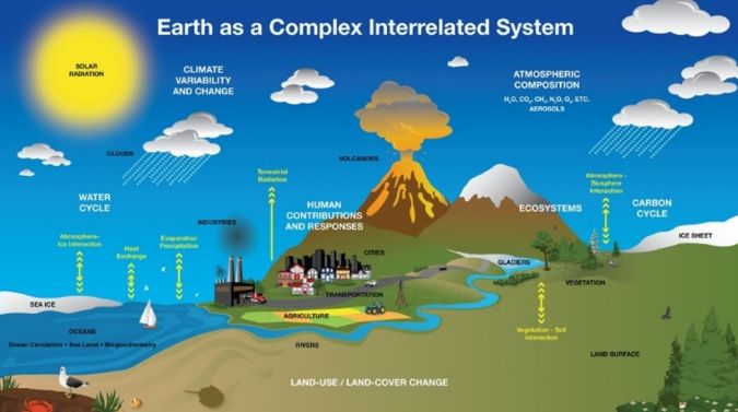
The United Nations Sustainable Development Goals (SDGs) were drawn up to improve the resilience of our complex living environment in the face of changing conditions, demands and hazards (Figure 1). According to SDG11, sustainable cities and human settlements are prioritized. This involves promoting sustainable land-use planning and management, as well as addressing issues related to water, sanitation, drainage and solid waste management. Moreover, there is an emphasis on the integrated provision of environmental infrastructure. Additionally, contemporary climate problems demand the redesign of spaces and infrastructures in cities around the world.
As a data-driven model incorporating computational simulations and artificial intelligence (AI), a city digital twin (DT) facilitates comprehensive assessments of the environmental, social and economic impacts of urban planning processes and decisions. As such, a city digital twin has the potential to support the attainment of SDG11.
City planners can employ DTs to simulate and evaluate various development scenarios, aiding in informed decision-making for infrastructure, transportation and public services. Additionally, these twins can contribute to smarter energy grids, traffic management and resource allocation, thereby fostering more sustainable and efficient urban environments. They can also empower citizens with real-time data for better navigation and city interaction. In essence, city DTs can serve as transformative tools, shaping the cities of the future by enhancing their functionality, sustainability and liveability.
Creating city digital twins
The derivation and generation of DTs for new or planned structures requires state-of-the-art methods and is a different task then merely representing built-up areas. The required data and specifications for the resulting virtual replica can be incorporated into the planning, design, construction and operation processes. Creating DTs for existing, large-scale environments, e.g. entire cities, is a challenging task. It requires existing buildings, objects, infrastructure and systems to be mapped into a virtual representation, e.g. using remote sensing, mobile platforms equipped with sensors and various other sources of geospatial data. In that vein, sources of very useful input data could include existing building information models (BIMs) or 3D city vector models based on standards such as CityGML. However, most DTs also required dynamic data (behaviour and sensor data) in addition to the static geometric data including semantics and appearance. A fusion of different, heterogeneous datasets, captured at different frequencies (e.g. annually, daily or up to every minute), is required to provide up-to-date information on demand for a variety of applications.
In short, for the creation of these complex models, the following is needed:
- Dynamic/live representation of assets with past, current and future states
- Integration in virtual platforms of real-time data from sensors for continuous analysis through Internet of Things (IoT)
- Simulation and prediction capabilities based on real-world data
- Utilization of AI and data analytics for enhanced outcomes
- Support for informed decision-making and personalized solutions
Implementation challenges
In today’s rapidly evolving urban landscape, the behaviour of urban environments exhibits a remarkable level of dynamism. To truly understand and navigate this complexity, a multifaceted approach is required that encompasses spatial, temporal and semantic information. The sheer volume of data needed to reconstruct and fully grasp the intricacies of a city is huge. A diverse array of data sources support this data-driven quest for urban insight, ranging from Lidar and aerial imagery to terrestrial and satellite data, as well as the continuous stream of information from IoT sensors. These sources, when combined, serve as the fundamental ingredients for DT creation. In addition, a solid foundation is required in the form of geodata infrastructure organized within spatial databases. This serves as the backbone, ensuring the accurate representation of the DT and its connection to the physical world.
To tackle this data-rich environment, a robust computing infrastructure is required. Moreover, scalability is key to enable a seamless transition from modelling individual buildings, to capturing the essence of an entire city. Automation and analytics, powered by AI, are valuable tools in this endeavour. With AI it is possible to classify urban features, detect objects and perform semantic partitioning, all of which contribute to a more profound understanding of urban behaviour. However, it is important to note that interoperability remains a challenge that needs to be addressed. For DTs to reach their full potential, data exchange must adhere to common standards, allowing different systems to communicate seamlessly and share crucial insights.
However, within the context of this ambitious quest for urban intelligence, the considerations of cost and investments must not be overlooked. Hardware, software, data management systems and analytic tools all come with financial considerations. A rigorous cost-benefit analysis becomes an essential compass guiding municipalities towards effective decision-making in this ever-evolving landscape.
In addition, the concern for data privacy, security and governance is integral to digital twinning. Safeguarding sensitive information is paramount when working with DTs, necessitating robust measures to ensure the integrity and confidentiality of the data.
3 examples of successful city digital twin applications
1. Digital twin for ground water table (GWT) monitoring and control
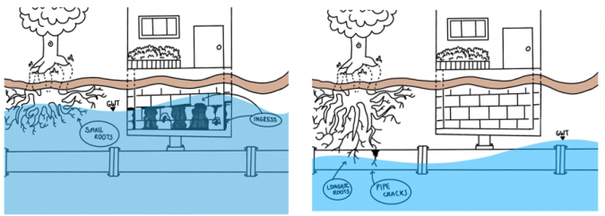
Managing groundwater in cities is increasingly challenging due to climate change-induced fluctuations in groundwater levels. These fluctuations, caused by more frequent and intense droughts and heavy rains, create problems such as waterlogging and flooded buildings. One common approach is to use groundwater control pumps, but they often have fixed capacities that may not suit extreme conditions. In low rainfall periods, the water table can drop, affecting vegetation and underground structures. Conversely, heavy rainfall can lead to shallow tree roots and basement water ingress, causing damage and flood risks. Balancing these challenges is crucial for effective groundwater management in urban areas (Figure 2).
The developed solution includes a DT model based on the Unity game engine that incorporates real-time GWT data from sensors distributed across the city. The solution integrates real-time data, prediction models and connectivity with pumping machines in a 3D photorealistic city model to support dynamic GWT control. The real-time data is based on the 273 sensors available from the public ‘Twents Waternet’ website. An algorithm has been developed to predict the groundwater level based on rainfall data that uses the GWT level with a combination of IoT protocols as triggers in the 3D game engine to de/activate a water pump in the physical world. The model also includes features such as historical data visualization based on previous sensor readings and a predictive machine learning model that uses decision trees to predict GWT depth based on historical and recorded precipitation data. The solution provides an interactive visualization of the GWT and aids the decision-makers by identifying areas that require automated water pump drainage. The associated research contributes to the development of an integrated and effective groundwater management and control system and facilitates sustainable water management practices in urban areas (Figure 3).
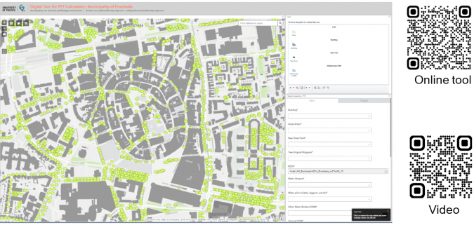
2. Digital twin for physiological equivalent temperature (PET) calculation
Urbanization, climate change and the ‘urban heat island’ effect have created the need to accurately assess thermal comfort. PET offers a comprehensive means of quantifying the combined effects of air temperature, humidity, wind speed and solar radiation on human perception of thermal conditions. By providing a metric that integrates multiple environmental variables, PET empowers urban planners, architects and environmental scientists to design spaces that prioritize human comfort and health. The development of a unified methodology using PET as a metric for heat stress was prompted by the abundance of different heat maps produced by various agencies using different metrics and methods.
Therefore, a DT-based model for PET calculation has been developed to identify the effect of adding (or removing) trees, buildings, water bodies, green areas or buildings. By combining empirical meteorological and GIS data, the model offers a cost-effective and practical approach to generating heat maps. It allows for the estimation of urban air temperatures and wind speeds using routine weather observations and information about land use and building geometries. Its goal is to reduce temperatures in key urban areas, enabling urban planners and decision-makers to identify impactful changes without the need to invest in untested solutions or to commit resources without prior knowledge of the expected outcomes.
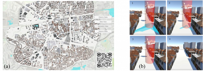
The potential for the DT for PET calculation to support collaborative and multidisciplinary street planning, evidence-based policies and enhanced citizen climate awareness has been demonstrated in the Dutch city of Enschede (Figure 4).
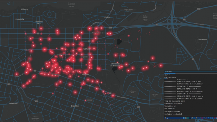
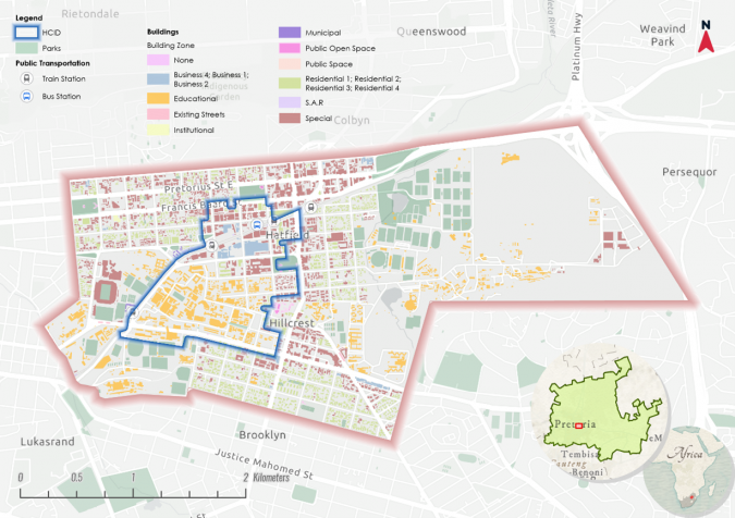
3. Digital twin for solid waste management
A massive amount of solid waste, exceeding two billion metric tons, is produced annually worldwide. Municipalities in countries across the globe are grappling with the challenge of managing this, often with limited collection services, and Pretoria in South Africa is no exception (Figure 5).
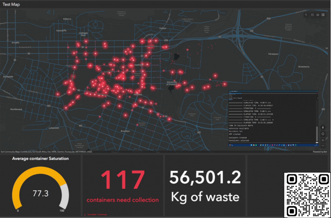
Therefore, a waste management digital twin prototype has been developed, featuring stakeholder prioritization, citizen participation for locating waste sites, waste generation simulations, waste-collection route optimization and a control dashboard. It integrates real-time monitoring, optimized collection routes and citizen engagement via the open-source tool Epicollect5.
A three-day data collection effort uncovered 1,270 containers and 820 littering sites, revealing distribution gaps – particularly in parks. Litter in park areas emphasizes the importance of providing well-distributed containers and prompt maintenance. Photos aid issue identification, while citizen engagement improves accuracy and efficiency. Waste generation simulations provide insights into flows and optimal container locations, aimed at reducing fuel use and emissions (Figure 6).
Waste generation simulations provide information about waste flows, low-capacity areas and optimal container locations. Optimized collection routes are proposed to reduce fuel use and emissions. A control dashboard has been developed which includes stakeholders’ system requirements and displays 11 indicators on three maps. The prototype lays the foundation for waste management digital twinning that is scalable to different areas, vehicles and production levels.
Conclusion
Digital twins have evolved as powerful tools that enable the replication, simulation and analysis of real-world systems in a virtual space. The creation and application of DTs supports a transformative approach to understanding and managing complex systems, particularly in urban environments. However, due to the abovementioned challenges related to DT creation, there is a risk of producing fragmented solutions that remain at the pilot project stage. To make DTs practical and implementable, the ongoing challenges should be addressed together with the stakeholders. Nevertheless, as various successful implementations already show, this technology holds immense potential across various sectors, including urban planning and infrastructure management.
Acknowledgements
The authors would like to express their sincere gratitude to Dr Pirouz Nourian and Dr Ir Leon olde Scholtenhuis for their valuable contributions to the joint supervision and collaboration.
Further reading
Cárdenas, Ivan L., Morales, Luis Rodrigoandrés, Koeva, Mila, Atun, Funda, & Pfeffer, Karin. (2023, August 31). Digital Twins for Physiological Equivalent Temperature Calculation Guide. Zenodo. https://doi.org/10.5281/zenodo.8306456
Kumalasari, D., Koeva, M., Vahdatikhaki, F., Petrova Antonova, D., Kuffer, M. Planning Walkable Cities: Generative Design Approach towards Digital Twin Implementation. Remote Sens. 2023, 15, 1088. https://doi.org/10.3390/rs15041088
Rajan, V., Koeva, M., Kuffer, M., Da Silva Mano, A., Mishra, S. Three-dimensional Modelling of Past and Present Shahjahanabad through Multi-temporal Remotely Sensed Data. Remote Sens. 2023, 15, 2924. https://doi.org/10.3390/rs15112924
Ying, Y., Koeva, M., Kuffer, M., Zevenbergen, J. Toward 3D Property Valuation – A Review of Urban 3D Modelling Methods for Digital Twin Creation. ISPRS Int. J. Geo-Inf. 2023, 12, 2. https://doi.org/10.3390/ijgi12010002
La Guardia, M., Koeva, M. Towards Digital Twinning on the Web: Heterogeneous 3D Data Fusion Based on Open-Source Structure. Remote Sens. 2023, 15, 721. https://doi.org/10.3390/rs15030721
Khawte, S. S., Koeva, M. N., Gevaert, C. M., Oude Elberink, S., and Pedro, A. A.: Digital Twin Creation for Slums in Brazil Based on UAV Data, Int. Arch. Photogramm. Remote Sens. Spatial Inf. Sci., XLVIII-4/W4-2022, 75–81, https://doi.org/10.5194/isprs-archives-XLVIII-4-W4-2022-75-2022, 2022.
Nourian, P., Martinez-Ortiz, C., Ohori, K.A., (2018). Essential Means for Urban Computing: Specification of Web-based Computing Platforms for Urban Planning, a Hitchhiker’s Guide, Urban Planning 3 (1), 47-57 https://doi.org/10.17645/up.v3i1.1299

Value staying current with geomatics?
Stay on the map with our expertly curated newsletters.
We provide educational insights, industry updates, and inspiring stories to help you learn, grow, and reach your full potential in your field. Don't miss out - subscribe today and ensure you're always informed, educated, and inspired.
Choose your newsletter(s)


