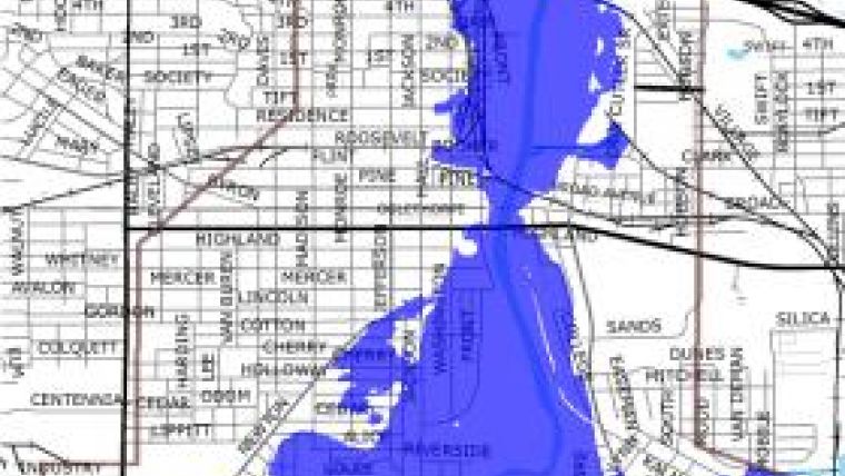
Flood Inundation Map
A new online and interactive flood preparedness tool is now available for the Flint River. Scientists from the US Geological Survey (USGS) and the National Weather Service (NWS) developed the new Flood Inundation Map to improve flood warnings and emergency management along the Flint River in Albany, GA.
The creation of the Flint River Flood Inundation Map tool is a result of a national pilot project between the USGS and NWS, and is the first of its kind to be completed in Georgia. USGS Associate Director for Water, Bill Werkheiser, explains: "This new flood preparedness tool highlights how these agencies and local officials are working together towards creating more resilient communities, providing better flood preparedness and responses to flooding."
The initial work conducted by the USGS, NWS, Federal Emergency Management Agency (FEMA), Georgia Emergency Management (GEMA), and Georgia Department of Natural Resources (GaDNR) and Georgia Tech, to map the 1994 Alberto Flood, provided a critical framework and foundation for modeling the Flood Inundation Mapping program. Since the 1994 flood, the NWS, the USGS and the City of Albany continue to improve and upgrade existing forecasting services. Bill Werkheiser remarks: "We do not want history to repeat itself so we are using today's more accurate tools in order to prepare for flood events before they occur."
The Flood Inundation Mapping product is an interactive web-based tool that shows the extent and depth of flood waters over given land areas. These maps enable management officials and residents to see where the potential threat of floodwaters is the highest. Other monitoring tools that provide flood information include streamgages, which provide real time data via satellites to the USGS and NWS for many purposes, including water supply, drought monitoring, and flood warnings. Relative to real time streamgage readings, the Flood Inundation Maps illustrate where floodwaters are expected to travel based upon NWS flood forecasts.
Real time stream flow data is also used for other new flood preparedness tools such as the USGS WaterAlert, StreaMail, and Flint RiverCam. These new tools can verify streamgage readings at remote locations, and can text or email you when a critical threshold is reached. Citizens can stay informed, and more importantly, stay safe with such accurate, up to date information. Brian McCallum, assistant director of the USGS Georgia Water Science Center adds, "The new Flood Inundation Map product combined with WaterAlert and RiverCam will allow citizens to make informed decisions during severe floods."
Together these new tools provide critical information to emergency management officials enabling greater flood preparedness. In addition, the Flood Inundation Map tool will facilitate more detailed forecasts of impacts and will enable emergency personnel from FEMA, state agencies, and local agencies to make quick decisions about when and how to evacuate residents threatened by rising floodwaters.

Value staying current with geomatics?
Stay on the map with our expertly curated newsletters.
We provide educational insights, industry updates, and inspiring stories to help you learn, grow, and reach your full potential in your field. Don't miss out - subscribe today and ensure you're always informed, educated, and inspired.
Choose your newsletter(s)


