How El Salvador is empowering growth and efficiency through mapping
Country-wide transformation using cadastral geospatial information for strategic decision-making
Through the National Registry Center (CNR), the government of El Salvador is embarking on a large-scale project to map the complete country (an area of 20,742km2), with the 14 departmental capitals and Surf City mapped at a higher level of detail. The aim is to overcome years of technological laggardness with an updated dataset and online mapping applications shared across government entities to support better decision-making.
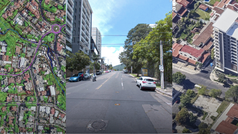
El Salvador is a very densely vegetated country with a challenging topographical landscape, since 76% of the territory features slopes with more than 30% inclination. These characteristics are perfect for growing some of the best coffee plants, but make mapping difficult. The country is not visible in Street View, and the current general-use map applications (i.e. Google Maps, Apple Maps, Mapbox, etc.) only publish satellite imagery and terrestrial panoramas uploaded by users, which means at best 0.6m ground sample distances (GSDs).
The 2.7 million parcels that make the CNR’s land registry maps are grouped in individual block-level CAD files, which are difficult to query for specific needs, such as finding lots with particular investment characteristics. Previous orthophotos were ten years old and in low resolution (60cm/px). Land registry and parcel-boundary review processes were paper-based and required field inspections, resulting in processing times of over two months, not to mention being imprecise. The inherited state of affairs in El Salvador required action. To reduce processing times, the CNR needed new tools to match the information necessities to support the Presidential Governmental Plan called ‘Plan Cuzcatlan’. CNR’s challenge was to modernize its dataset and tools in record time (two years) at a fraction of the budget used in previous attempts.
From 2D data to omnidata
The updated dataset had two prerequisites: using the latest technology and building the capacity within the CNR to update such information by acquiring infrastructure.

The 14 most important cities in El Salvador represent over 80% of both the economy and of CNR’s processing requests, so they were prioritized for a higher level of detail. This area, totalling 751km2 , was surveyed for the first time using multiple simultaneous sensors. For vertical imagery, a high-resolution photo (8cm GSD) unveiled many details hidden between the pixels. The obliques and Lidar were flown at the same time, providing the capacity to see the building facades, understand multistorey constructions on the side of the cliffs, and quantify the buildings under the trees.

The rest of the country was surveyed at 20cm/px resolution providing country-wide coverage. To update the aerial part of the dataset, fixed-wing and multirotor uncrewed aerial vehicles (UAVs or ‘drones’) were acquired by CNR. Drones complement crewed surveys by quickly providing highly detailed imagery for small areas (of less than 5km2).
Street mapping has become such an essential part of geospatial datasets that it is hard to imagine finding directions – or managing a country – without it. Cities are constantly changing, so CNR targeted the long-term game. Instead of contracting out the mobile street mapping, the organization decided to learn by doing. As 1,750km of streets were travelled, the designer of the mobile mapping platform transferred the knowledge and capacity to CNR’s technical staff. The El Salvador Maps mobile mapping unit is now on its way mapping over 250km per month.

Evolving to web mapping applications
Mapping operators previously had to go through many server directories to find the correct orthophoto sheets and vector files, then load them into the client to perform a specific procedure on a parcel. This could take 10 to 45 minutes, depending on the complexity and size of the area. The ‘El Salvador Maps’ project consolidated isolated files into a single geodatabase. Now, it takes no more than 10 seconds to zoom into a specific area and get started.
Everything runs on eCarto, a PostgreSQL DB and a .NET web stack. Among the online mapping apps developed for this project, three stand out: cadastral maintenance, vertical condominium management, and for-sale data preparation. Cadastral maintenance allows CNR’s operators to validate property coordinates provided to the omnidataset and gain an accurate understanding of the situation from their desks. Subdivisions, fusions and boundary rectifications can be done through the platform by updating existing cartography online. Meanwhile, vertical condominium management has always been a challenge in 2D environments. The evolution to 3D has provided the flexibility required to address multiple ownership rights in the same building.
Last but not least, citizens, companies and other government entities regularly request specific areas of interest from CNR. The preparation of such datasets was highly demanding in terms of manpower, as a jigsaw of different sources needed to be assembled to achieve the requested task. All three above-mentioned applications have transformed CNR’s ability to respond faster to end users, including by offering one-day processing times.

Empowering decisions
The highest decision-making authority in El Salvador is the President and the Congress. Decisions are fast-paced and require equally fast provision of information. Thanks to the new omnidataset and tools provided by El Salvador Maps, CNR has been able to provide timely information to support the design and construction of the country’s second international airport, the Pacific Train, infrastructure for law enforcement, and green energy generation clusters (solar, wind and volcanic).
Moreover, in search of budgetary and bureaucratic efficiencies, on 1 June 2023 the nation’s president announced plans to reduce the current 262 municipalities to 44. The new municipal boundaries will be aligned with topographical features, land-ownership rights will be allocated to the right municipality and the territory will be constitutionally delimitated, all supported by a well-georeferenced framework.
The prestigious ‘El Salvador Maps’ project
A prestigious project generates the perception of achievement through quality, usefulness and the right use of technology. Three elements need to coexist for such a project: 1) high-accuracy data, 2) powerful tools to be leveraged, and 3) new processes to turn data into information and empower decisions. CNR has accomplished all three. El Salvador is growing and making its mark on the international scene through information-supported decisions. There is still a long way to go for this small Central American country, but the foundations are now firmly in place for it to build upon, and it is likely to be imitated by its siblings in the region.


Value staying current with geomatics?
Stay on the map with our expertly curated newsletters.
We provide educational insights, industry updates, and inspiring stories to help you learn, grow, and reach your full potential in your field. Don't miss out - subscribe today and ensure you're always informed, educated, and inspired.
Choose your newsletter(s)


