How to Capitalize on the Opportunities in the Golden Era of Geospatial
Interpreting Expectations and Identifying Insights from Our 2022 Industry Survey
How is the geospatial industry evolving in today’s turbulent times? The climate crisis, the COVID-19 pandemic, shifting geopolitical balances – societal challenges are having a major impact on the global economy as a whole as well as on many individual countries and industries. This year’s edition of the annual 'GIM International' industry survey reveals a number of striking trend shifts. This report interprets the findings and provides interesting insights for geospatial businesses who are looking for opportunities for future growth.
Due to a number of factors, the present – and the future – is still plagued with uncertainty for many of us. When the crystal ball is so clouded and the road ahead appears to be littered with obstacles, how can you develop the optimal strategy for your company? Thankfully, there are some bright spots on the horizon. As COVID-19 gradually fades into the background, many new opportunities are emerging in a number of sectors, and the geospatial industry is at the front of the queue to seize them.
Generating close to a thousand responses from all over the world, this year’s GIM International industry survey provided us with a wealth of insights and paints a colorful picture of the professional geomatics landscape. Where does the industry see new opportunities? How is the role of the land surveyor evolving? What are the biggest constraints? How do technological advances benefit the sector? What investments are organizations planning? And what gives cause for all the optimism that shines through in the results of our survey?
Prospects for the Surveying and Mapping Market
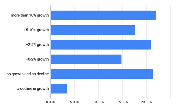
Let’s start our journey through the survey findings with the current mood across the geospatial community. We asked our readers how they view the prospects in the surveying and mapping industry in 2022, compared with the past couple of years. 48.8% of the respondents indicate that they foresee better market circumstances, while 26.3% are even more optimistic and rate the prospects as ‘much better’. So what forms the basis for this optimism (Figure 1) about a brighter short-term future? One of the respondents catches the sentiment of many other responses in a nutshell: “Geospatial data has become the core of decision-making in many different engineering and environmental markets”. The influence of challenging circumstances such as the COVID-19 pandemic and climate change is also frequently mentioned as driving the awareness of – and also demand for – geomatics throughout the world. Many mapping and surveying professionals expect this increased need for the fast and reliable collection and processing of huge volumes of geospatial information to be permanent, especially at governmental level. The ongoing digital transformation and the associated growth in the use of spatial data is also contributing to the good mood.
The Influence of COVID-19
The optimism might have been even greater were it not for the coronavirus-related concerns expressed by various respondents. Travel restrictions (43.1%), national lockdowns (22.8%) and absenteeism due to illness (12.6%) are the top three effects of the pandemic with the biggest business impact. There is light at the end of the tunnel, however. The large majority of the respondents think that COVID-19 restrictions will soon end (and let’s hope they are right!), which will automatically improve their business prospects. Additionally, one good thing to have come out of COVID-19 is that many organizations and governments have woken up to the importance of geomatics in supporting the intelligent study of people and land. As a result, as we near the end of the pandemic (or at least get used to living with the virus), all activities that are supported by geospatial data will further increase, which will boost the industry by generating more work and opening up new market segments.
Planned Investments in Geospatial Hardware and Software Solutions
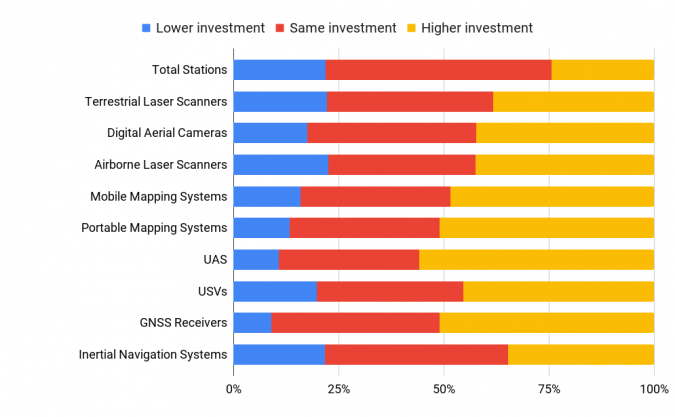
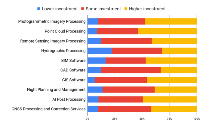
This positive vibe in the mapping and surveying market leads us onto the question of future plans. How does the level of investment planned for 2022 compare with last year? Zooming in on the hardware and software solutions reveals some clear trends. The hardware frontrunners are unmanned aerial systems (56%), GNSS receivers (51%) and portable mapping systems (51%), with mobile mapping systems (48%), airborne laser scanners (42%) and digital aerial cameras (42%) also topping many companies’ wish lists (Figure 2). In terms of software (Figure 3), the ‘most wanted’ solutions are point cloud processing software (54%), artificial intelligence post-processing software (49%), building information modelling (BIM) software (47%), photogrammetric imagery processing software (47%) and GIS software (46%).
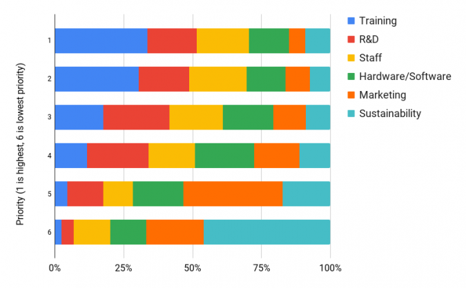
But how should we interpret these results? It is interesting to take a closer look at how the survey respondents intend to prioritize their organizational investments over the next three years. Across the board, among professionals from all corners of the broad geospatial spectrum, training & competency development, research & development, and increasing the size of the workforce achieve higher scores than investing in hardware and software (Figure 4). This does not mean that surveying equipment and solutions have lost relevance; quite the opposite, according to the rest of the survey. However, this order of priorities gives a good sense of what companies and organizations need most urgently: skilled staff and a sufficient supply of new talent.
The Geospatial Workforce Gap
Indeed, many of the responses in our survey echoed the following lament: “There is a lot more demand for our services. However, we are limited in taking advantage of the demand by a lack of trained and experienced personnel.” This hits the nail on the head. The lack of sufficiently skilled employees coincides with a rising demand for geospatial services due as mentioned above, creating a perfect storm. The talent shortage has been in the making for several years, but we have now reached the point that the available workforce is simply too small to support the market demand. This poses a threat to the future of the geospatial industry in terms of limiting its capacity to innovate and grow, and making it susceptible to external competition.
The mapping and surveying profession urgently needs to find a way to attract more people who can operate laser scanners, aerial cameras, total stations, GNSS receivers and unmanned aerials vehicles (UAVs or ‘drones’), process the resulting data and turn it into valuable information. As most organizations will be fishing in the same pond in their search for new employees, it is crucial to inspire enthusiasm for the geospatial industry among youngsters at an early age. As an added pressure, the number of surveyors is set to shrink even further as many current industry professionals are set to retire in the not-too-distant future – as underlined by the average age of our survey respondents.
Many of the comments from respondents underline the changing nature of the surveying profession. ‘Digital natives’ are a very welcome addition to the workforce as their tech-savvy knowledge and skills are perfectly aligned with the direction in which the geospatial industry is heading. However, this is at risk of being held back by another phenomenon, which one respondent summarizes as follows: “There have never been enough surveyors to satisfy the demand and this is being magnified by the poor level of attention paid to mathematics and science at high school level, which is not equipping the young students with the adequate technical background to succeed at university”. Needless to say, this differs from one country or region to another, but it probably sounds familiar to many of our readers around the world.
How AI is Revolutionizing Geomatics
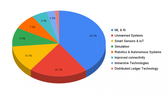
Whether they are relatively new on the career ladder or seasoned professionals, all geospatial specialists are heavily dependent on the very latest technology, techniques and software. To gain more insight into the industry’s current digital transformation journey and how it influences the view of the wider world, we asked our readers which technological developments they expect to be the main driver in the coming years. Receiving 40% of the votes, machine learning & artificial intelligence (AI) is widely regarded as a pivotal force (Figure 5), followed by unmanned systems (20.2%) and smart sensors & the Internet of Things (13.2%).
In the past, AI has often been misused as an umbrella term to the point where it was at risk of becoming an overhyped buzzword. But as the technology has matured and real-life applications have become apparent, the geospatial industry is embracing it and AI is already part of many geospatial solutions. One of the comments from the survey sums it up appropriately: “AI is at the centre of data analytics and, since geomatics deals with spatial data, AI should be seamlessly incorporated in geomatics. In other words: high-end geospatial technology, imagery and artificial intelligence converge and are melting together in GeoAI”. However, another respondent points out that there is a downside to AI becoming such a crucial element, since there is a shortage of graduates with knowledge of AI and machine learning within the scope of geomatics. This once again highlights the urgency of the labour/talent issue.
Surveyors Hold the Key to More Equality
This brings us on to the truly global nature of the geospatial industry. Each of the world’s countries and regions has different perspectives and characteristics, such as unique climate conditions, diverse building types and distinct environmental, economic and social priorities. The situation in developing economies calls for different solutions from the geospatial community than in developed countries. This is aptly described by a respondent from South Africa, who is one of many surveyors active in land rights. “Land rights is an important development area for geomatics, not only in South Africa but also in many other countries across the globe, as development gets held up by various legal hurdles – from housing to renewable energies. This is the case in many countries, especially where legislation is still evolving and changing extensively. Our profession holds the key to progress here.” Another respondent in this year’s survey regards the accuracy and availability of geospatial information to be the most important growth area for the geomatics industry: “This sets the improvement of planning and development in motion, which leads to increased security of tenure and protection of people-to-land relationships.”
Against this global backdrop, there is one issue that affects the entire planet: climate change. The geomatics industry offers tools that can help to mitigate, adapt to and perhaps even halt climate change. In particular, the geospatial community can play a key role in the energy transition by helping to develop a roadmap to a carbon-neutral society powered by renewable energy. This places a considerable responsibility on the shoulders of geospatial professionals.
Wealth of Opportunities within Reach
Our industry survey has provided a wealth of information that contributes to a deeper understanding of the current – and likely future – state of the geospatial sector. Besides the lingering cloud of uncertainty caused by the persisting coronavirus situation, the mood among the geospatial community is optimistic. There is an abundance of work for surveyors, but at the same time there are clear concerns in the industry about the urgent need to recruit and train sufficient professionals to handle the ever-growing workload in the very near future. Thanks to the changing nature of the surveyor’s role, many geomatics tasks no longer involve fieldwork in all weathers, but can increasingly be performed from the comfort of an office. Likewise, surveying engineers are shifting towards the role of geospatial data managers, in which the processing and interpretation of geospatial data is at least equally important as capturing it. Meanwhile, although the nature of geomatics solutions required differs from one region to another depending on a variety of local circumstances, the threat of climate change is one that impacts the whole of planet Earth, and the geospatial community has a key role to play in tackling this challenge. This, along with the energy transition, the digital transformation in the construction sector and the path towards maturity for digital twins for use in construction, smart cities and many other applications, means that a whole range of exciting and profitable new opportunities are within reach for our beautiful profession.
3 Reasons Why AI Is Gaining Traction in Geomatics
To a lot of people, artificial intelligence (AI) and machine learning (ML) have previously been slightly intimidating topics. Recently, however, AI has been gaining more traction in the world of geomatics – but why exactly? Here are three reasons:
1) The computational power is increasing substantially every year, making it much easier to work with large datasets and AI platforms. Machine learning algorithms in combination with datasets of millions of samples can now be run on most laptops and even through online servers such as the Google Earth engine.
2) Open-access (i.e. free of charge) spatial data is becoming available on different scales, making vast amounts of data available for public use. This is making it easier for developers to gain access to the necessary volumes of high-quality data needed to train and test machine learning methods and models.
3) Machine learning platforms are easier to use than ever. With online libraries providing all the necessary functionalities along with extensive tutorials, guides and examples freely available, the barrier to entry into the world of machine learning has been lowered. Now, almost anyone can capitalize on this possibility for more efficient and higher quality workflows.
An increasing amount of research is being done into how AI can be combined with geospatial data for improved performance in real-life situations. Multiple studies show that AI holds the potential to automate many of today’s manual data processing activities including the production of complex numerical models and pipelines. This will save users time and (when applied correctly) can provide far more accurate results. Hence, for the three reasons outlined above, we can expect to see AI gaining further traction among geomatics professionals and practitioners eager to incorporate it into their future projects.
Acknowledgement
The author acknowledges Lars Langhorst for his contribution about artificial intelligence in the geomatics profession.

Value staying current with geomatics?
Stay on the map with our expertly curated newsletters.
We provide educational insights, industry updates, and inspiring stories to help you learn, grow, and reach your full potential in your field. Don't miss out - subscribe today and ensure you're always informed, educated, and inspired.
Choose your newsletter(s)


