Investigating the slow uptake of technology in developing countries
A terrestrial laser scanning study in Nigeria
Which factors contribute to the slow adoption of TLS in Nigeria? These insights can help to stimulate the uptake of instrumentation and enhance professional surveying in other developing countries across Africa.
Instrumentation plays a critical role in both the theory and practice of land surveying. However, slow adoption of technology can pose significant challenges to professional practice. This is particularly evident in Nigeria, where the uptake of high-end surveying techniques such as terrestrial laser scanning (TLS) has been sluggish. The lack of research on the specific aspects that influence the adoption of modern TLS technology in different countries and individual cities is a significant knowledge gap that undermines efforts to improve surveying practices. To address this issue, the authors of this article have studied the factors that contribute to the slow TLS adoption in Nigeria. The insights gained from this research are applicable to other developing countries across the African continent and beyond, and can help to enhance understanding of this important issue.
Instrumentation has been a foundational element of land surveying (LS) since antiquity. Ancient populations employed multiple primitive tools to comprehend the land and its characteristics, and to illustrate them graphically for title, fiscal and legal objectives. It has been established that those primitive tools are, in fact, the predecessors of today’s conventional LS tools such as tapes, theodolites and total stations, and techniques such as chaining, the ray method and photogrammetry.
Over time, these methods and the equipment used have become increasingly cumbersome and incapable of obtaining data with the precision required for definition of the organic and built world with the desired accuracy. Moreover, traditional LS approaches can require unnecessary intrusion on a site, not to mention the extensive project execution timeframe. Additionally, traditional LS is not suited for collecting the datasets demanded for the modelling operations of the intricate aspects entrenched in many of today’s projects. While conventional LS procedures can only do point sampling, terrestrial laser scanning (TLS) offers a technological solution to many of these challenges, thanks to its ability to sample three-dimensionally and on the surface with high accuracy.
TLS project to model an offshore facility
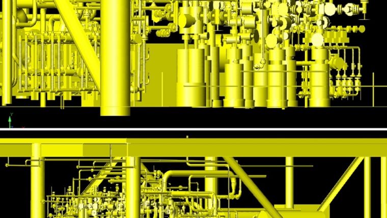
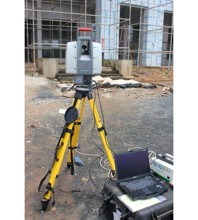
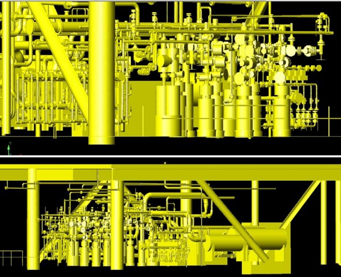
Recently, an engineering survey in Nigeria examined the capacity of TSL to generate a three-dimensional model, employing a fusion of interpolations to transform data into surface models and address the shortcomings with traditional LS data acquisition methods. This process is non-intrusive and aggregates millions of data points at great speed. The project was aimed at constructing an as-built model – a three-dimensional likeness – of the offshore gas platform to aid in the planning and execution of retrofitting and refurbishment of the facility. The project used the HDS Leica ScanStation-2 TLS (see Figure 1) with the following properties:
- Position: 6mm (at 1m-50m range, 1δ)
- Distance: 4mm (at 1m-50m range, 1δ)
- Angle (horizontal/vertical): 0.003⁰(60μrad/60μrad).
The main methodological aspects of the project were:
- Choosing a suitable location for the TLS and targets
- Authorizations from the management of the offshore facility for sampling
- Systematic scanning of the facility to capture 3D point clouds
- Data processing (including auto-rectification, point cloud filtering and modelling and exporting of the maps) of the point cloud using Cyclone 0 software.
Overcoming obstacles
The TLS fieldwork encountered some obstacles, predominantly the unfavourable conditions typically associated with marine environments, such as gusty winds and downpours. Strong winds impeded the operation of the scanner, making it move faster than normal when it was going with the breeze, and impeding its progress when the scanner was facing in the opposite direction. To overcome this obstacle, field technicians placed the scanner in positions where segments of the platform shielded it from the wind. While scanning in the rain, raindrops picked by the Leica ScanStation 2 introduced extraneous noise into the data which was interpreted as signals. In this case, the scanning operation was delayed until favourable weather conditions had returned. Despite these obstacles, the quality assurance of the finished product illustrates that the HDS Leica ScanStation-2 TSL produced a 3D as-built model of the offshore gas platform quickly and with high precision (see Figure 2).
Although TLS has proven to be immensely useful in the aforementioned project, and also in the wider LS and geomatics industry, its adoption in many of the third-world countries has been sluggish. The literature does not provide a definitive reason for the slow uptake of TLS in such countries. Therefore, the authors conducted a survey among 81 practicing registered land surveyors in Enugu, Nigeria, with a variety of experience, length of practice, academic qualifications and awareness of LS instrumentation.
The survey revealed that only approximately 3.7% of the respondents have used terrestrial scanning technology. Around 38% of respondents indicated that they had heard about the technology but not seen it, while around 45.6% said they had seen it but not used it for any practical LS activity. According to the data, there is a dominance of mostly regular LS operations, including cadastral services, engineering surveying and land information management (LIM). These can often be implemented using basic indigenous logistics. The findings underscore evidence of slow adoption of TLS in the study area and suggest that the contributing factors to this situation include lack of funds, poor technical capacity and the shrinking value and scope of work exclusive to traditional land professionals.
Implications and the way forward
Despite a plethora of issues associated with existing LS instrumentation, such as breakdowns, considerable inaccuracies and a lack of personnel and technical expertise, the overall contentment with the current LS instruments and practices, as measured by the study, appears to be acceptably high. Indeed, most land surveyors in the study area think that they do not need TSL or any other high-end surveying equipment. Nevertheless, they would be open to receiving and/or providing financial, political, policy-related or scholarly support that would boost the current and future professional profile of LS theory and practice in the region.
This underlines the essential importance of technology transfer and adoption, and emphasizes the value of instrument training as a requisite for the mandatory continuing professional development (MCPD) for surveyors. Moreover, the enhancement of the status of LS professionals is contingent upon conforming to existing global professional standards. This can only happen if local surveyors are willing to embrace and use advanced technology. This will improve the currently deteriorating prospects of surveying in Enugu, which also touches on matters concerning women in surveying (WIS) and the comprehensive geoinformation system of Nigeria.
Conclusion
Instrumentation has been a fundamental feature of land surveying for ownership and fiscal purposes throughout history. TLS can meet today’s demands for bigger and more accurate geospatial datasets, going beyond what traditional LS instruments and methods can accomplish. It provides the requisite capacity for rapid data acquisition, two- and three-dimensional modelling of intricate structures, and supports data transmission and collaboration. Results from a real-life project using the HDS Scanstaion-2 TLS to model an offshore gas platform and build an as-built map in Nigeria reveal that the scanning system is a suitable answer for new global problems in developing countries. But despite this potential, the acceptance of TLS is slow-paced in most of those countries, as evidenced by a survey among a sample of registered land surveyors in Nigeria. The momentary causes of this are the lack of funds to purchase modern equipment, lack of technical expertise and the declining status of the surveying profession in the region. However, more may be at play, and more research is required to comprehend all aspects of the TLS issue across different regions. This can them form the basis for developing initiatives and schemes aimed at enhancing the position of land professionals and the geospatial sector in developing countries.
Further reading
- Ebinne, E. S., Nkwunonwo, U. C., Nwaka, O. C., & Chiemelu, N. E. (2022). Slow-paced adoption of terrestrial laser scanning technology for land surveying operations in Nigeria’s geoinformation industry. Journal of Asian and African Studies, 57 (2), 369-387.
- Pinkerton M (2011) Terrestrial laser scanning for mainstream land surveying. Survey Quarterly 300 (65), 7–20.
- Trinder J and Han S (1999) Impact of new technologies on geomatics in 2010. Australian Surveyor 44 (1) 29–34.
- Wang W, Zhao W, Huang L, et al. (2014) Applications of terrestrial laser scanning for tunnels: a review. Journal of Traffic and Transportation Engineering 1 (5), 325–337.

Value staying current with geomatics?
Stay on the map with our expertly curated newsletters.
We provide educational insights, industry updates, and inspiring stories to help you learn, grow, and reach your full potential in your field. Don't miss out - subscribe today and ensure you're always informed, educated, and inspired.
Choose your newsletter(s)


