Lidar Data – A Perfect Tool for Archaeology
A few obstacles are making the usage of Lidar data in archaeology look exotic and perhaps even threatening, according to archaeologist Jošt Hobič from Slovenia, even though Lidar is almost a must when researching landscapes and archaeological sites today. He explains more about his seven years' experience of using airborne Lidar data in this column.
The first obstacle is Lidar data that is put behind a paywall – despite in effect being data that has been paid for by taxpayers’ money. Open data is more inclusive, and it stimulates more research. Luckily, a lot of countries around the world are releasing Lidar data as open data, and I hope the trend will continue in the future so that this obstacle will one day disappear.
I immediately fell in love with airborne Lidar data for archaeological sites the very first time I saw a visualization, since it was not only beautiful but also very useful for examining and researching landscape through another medium. At the time I was completely new to the GIS environment – studying archaeology back then had not prepared me for it. But I persisted and I learned a lot, mostly through trial and error and with the help of the GIS internet community. And this highlights the second obstacle: GIS is complicated. Most people who want to use Lidar data for archaeological research stop because making it ‘work’ is just too complex, especially if they only need visualizations for one archaeological site. And this is what I mean by the usage of Lidar data being ‘exotic’. This exclusivity often results in Lidar data not being used in big projects and excavations, even though its use could help to answer some questions and support planning decisions.
The third obstacle is a misconception about what Lidar data is. It is not a magic wand that will show us every archaeological site in a landscape and answer all our questions about the landscape’s history. Instead, because Lidar data captures all the surface features, we need to consider that it will also contain a lot of ‘non-archaeological’ features. Like any other archaeological record, this often leads to more questions than it answers. But for me, those questions are what make things so interesting.

As I see it, all three obstacles can be solved by offering more GIS courses during university degrees, providing online courses and tutorials, and giving open access to various pre-prepared Lidar visualizations. The first two are longer-term solutions and I must say there are already some positive changes in archaeology departments here in Slovenia and probably around the world. But the fastest and easiest way to open up Lidar data is by publishing pre-prepared visualizations, as WMTS services for example. This reduces the complexity of GIS workflows and of obtaining data (whether open or closed).
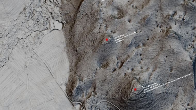
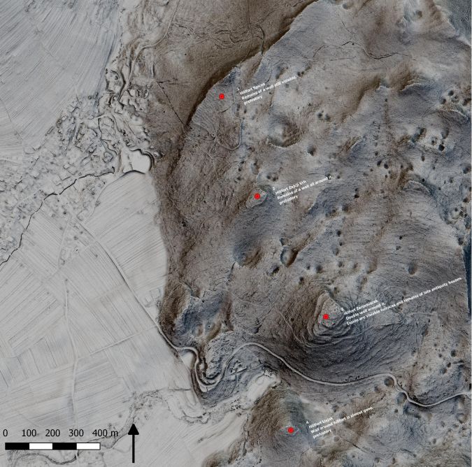
I have personally experienced just how much impact proper visualization can have on the usage of Lidar data. When the Registry of Slovenian Cultural Heritage GIS viewer was updated in 2018, we also added Sky-view factor (SVF) visualization of Slovenian Lidar data. Feedback from the archaeological and heritage sectors was mostly very positive. But I am most proud that we engaged people who are interested in archaeology and the general public. Because over 50% of Slovenia is covered by forests, lots of areas were completely unresearched. In the last two years, lots of people have sent us details of hundreds of new archaeological sites that they’ve found with the help of Lidar visualization; there’s so much new information flowing in that regional archaeologists cannot keep up with it all. There are also some very interesting projects going on in the UK (e.g. Beacons of the Past – hillforts in the Chilterns landscape) that use Lidar data to engage and actively involve people in researching and discovering archaeology in their surroundings.
Some members of the archaeological community fear that this kind of open-access data creates a threat by highlighting more targets for people with metal detectors looking to illegally excavate and sell archaeological finds on the black market. In my opinion, we need to tackle this issue not by closing the archaeological door, but by educating the general public and opening up the discipline so that archaeological heritage becomes everyone’s heritage, with a shared responsibility to keep it safe and maintain it. The visualization of Lidar data forces us heritage professionals to come down from our ivory towers. By presenting landscapes and archaeological sites in countless different and often colourful ways, it has the power to captivate many people.
Lidar has proven to be a perfect tool for making archaeological research less complex and making archaeology more open. That’s more than enough for me!

Value staying current with geomatics?
Stay on the map with our expertly curated newsletters.
We provide educational insights, industry updates, and inspiring stories to help you learn, grow, and reach your full potential in your field. Don't miss out - subscribe today and ensure you're always informed, educated, and inspired.
Choose your newsletter(s)


