Preserving history in the high Arctic
3D documentation of the Sveagruva coal mining settlement on Svalbard
Nestled in the high Arctic Archipelago of Svalbard, the Sveagruva coal mine and mining settlement once buzzed with activity until its closure in 2016. An extraordinary project is now underway to breathe new life into this abandoned place. The Norwegian Parliament and the site owner, the state-owned Store Norske Spitsbergen Kullkompani (SNSK), have taken up the challenge of restoring the area to its original natural state. Recognizing the importance of preserving the history embedded in this site, SNSK partnered up with the Norwegian Institute for Cultural Heritage Research (NIKU) to undertake the colossal task of documenting the area in 3D. In a race against time, NIKU has employed state-of-the-art technology to meticulously capture the essence of Sveagruva. The result? Mesmerizing visualizations that allow us to witness the site’s past glory and honour its legacy.
Sveagruva, a renowned mining community with nearly a century of coal-production history, holds a significant position in Norwegian industrial heritage. Having been under Swedish ownership until 1934, the mine later became the largest place of work on Svalbard, playing a crucial role in sustaining Norwegian employment on the archipelago and asserting Norway’s sovereignty as established by the Svalbard Treaty of 1920.
After mining operations ceased in 2016, an ambitious environmental initiative was set in motion to restore the area to its natural state as mandated by the Svalbard Environmental Protection Act. Accordingly, all mining infrastructure – including roads, buildings and other facilities – was to be removed, ensuring that glaciers and mountainsides could once again naturally flourish in the spirit of environmental preservation.
The looming removal of the facilities also sparked a drive to document and digitally preserve the cultural and industrial heritage of Sveagruva. This digital heritage project would ensure legal compliance and honour the site’s historical significance. Through detailed documentation and captivating visualizations, the project has safeguarded the legacy of Sveagruva, ensuring that future generations can appreciate its rich history.

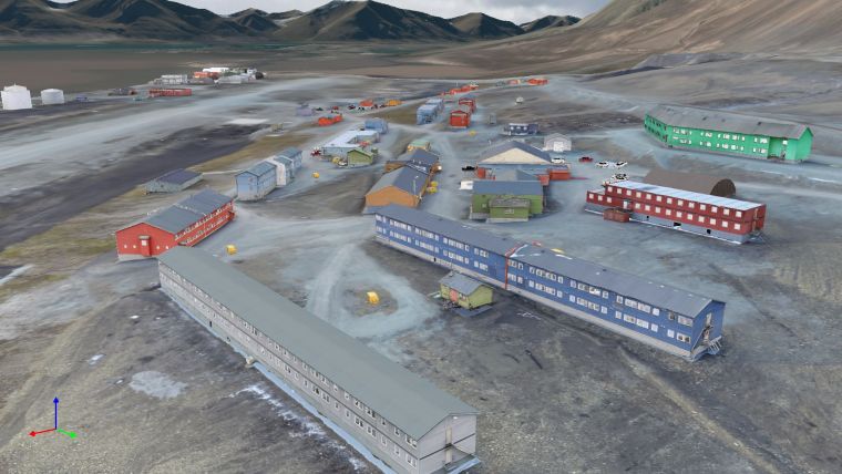
The mining settlement of Sveagruva
The mining settlement of Sveagruva, located in the picturesque Van Mijenfjorden, was a bustling industrial camp and community. Spanning approximately 15km, the site encompassed various areas, ranging from the expansive coal loading quay and shipping facilities at Kapp Amsterdam to the mine entrance of the Svea Nord mine, perched atop the Höganäsbreen glacier. At the heart of the settlement was the Svea Sentrum area, located roughly in the middle of the site. This central hub consisted of several buildings dedicated to housing, offices and recreational activities, as well as all other essential facilities in the miners' daily lives. The diverse structures and infrastructure showcased various architectural styles and purposes. From modest wooden buildings to large coal processing plants, an airport, a loading quay, an expansive workshop area, a power plant and numerous remnants of the earliest mining periods listed as cultural heritage, Sveagruva’s built environment reflected the multifaceted nature of the mining operations.
Project challenges
The comprehensive 3D documentation project in Sveagruva faced a multitude of unique challenges and complexities. Digitally capturing the diverse range of buildings and infrastructure with utmost precision demanded meticulous planning and execution to ensure accurate representation in the digital models.
The project’s ambitious nature and the demanding environmental conditions added further challenges. The limited time window available during the Arctic summer called for efficient planning and execution to make the most of the favourable lighting and minimal snow cover. Additionally, the remote location and rugged terrain of Svalbard presented logistical obstacles, necessitating careful navigation and coordination of a large team of up to 12 people and an extensive amount of equipment to ensure optimal data capture. Furthermore, the project team had to address the potential danger posed by polar bears roaming the area. Their possible presence increased the need for strict safety protocols and vigilant monitoring throughout the documentation process.

Documentation process
During a five-week timeframe, NIKU employed advanced tools and techniques to conduct the comprehensive documentation project in Sveagruva. With the strategic deployment of three RIEGL 3D laser scanners, five high-resolution DSLR cameras, two camera drones, GNSS and total station equipment, the team meticulously scanned and photographed around 130 buildings and structures. This multifaceted approach employing both laser scanning and photogrammetry methods enabled the detailed capture of physical features and architectural elements.
The documentation process followed a systematic approach for each building. The team established an extensive network of fixed points and reflective targets using land surveying techniques to ensure precise positioning. Laser scanning and photogrammetry techniques were then used for detailed building capture, selected based on factors such as shape, complexity and size.
Laser scanning served as the primary method, capturing millions of data points by measuring distances between the scanner and building surfaces. For intricate structures or those with unique architectural features, a combination of laser scanning and photography was employed. Comprehensive visual data was obtained using uncrewed aerial vehicles (UAVs or ‘drones’), photo poles and photographs from various angles. Despite challenges, the team’s expertise and dedication led to remarkable results. The fieldwork generated an extensive dataset, including over 6,000 individual scan positions and 200,000 photographs, totalling approximately 18TB of raw data.

Data processing
During the main processing phase, the RealityCapture software was applied to transform the collected data into high-resolution colourized point clouds. This involved combining laser scans and photographs to create detailed digital representations of each building. Prior to this, a crucial preprocessing step using the RiSCAN PRO software registered, georeferenced and colourized the raw scan data, ensuring precise alignment and positioning. The georeferenced and colourized information seamlessly integrated into RealityCapture, facilitating subsequent processing stages. Multiple photos from different angles were then integrated to densify the models and add realistic texture information, enhancing the highly detailed representations.
In the initial step of the processing workflow, high-resolution mesh models with photographic textures were generated. These mesh models served as the foundation for subsequent filtering and refining. Following that, the mesh models were exported as ultra-high-resolution point clouds, with each vertex representing a single point. The point clouds retained RGB information, preserving colour details captured from the photographs.

Visualization
For the Sveagruva project, NIKU collaborated with NUBIGON Inc., a software company specializing in 3D point cloud rendering. The company developed a customized version of its software specifically for this project to showcase the rich and detailed digital twin of Sveagruva. The software seamlessly integrates high-resolution point clouds, terrain models, additional 3D objects, text and image annotations, ultimately producing an immersive 3D experience for public engagement. Users can embark on a captivating journey through the mining settlement, exploring its intricate details and gaining an insight into its history.
A custom interface guides users through the digital twin of Sveagruva, providing an intuitive and informative experience with game controllers and a walk-on-terrain mode. High-end 3D visualizations do justice to the site’s historical significance. By leveraging the power of the NUBIGON software and customizing it to the specific needs of the Sveagruva project, the visualizations truly bring the mining settlement to life.
Implications and future display
The visualizations obtained through this comprehensive documentation project have significant implications for the preservation and dissemination of Sveagruva’s heritage. The immersive experiences will be initially showcased in a museum set up on Svalbard, allowing visitors to step back in time and gain a profound understanding of the area’s coal mining legacy. Furthermore, the generated models and underlying data have broader implications. They contribute to the field of cultural heritage management, providing a valuable resource for research, analysis and conservation efforts. The high-resolution point clouds and detailed visual representations offer a wealth of information for potential future investigations and studies. Whether for educational purposes, virtual tourism or public awareness campaigns, the digital representations of Sveagruva have the potential to be shared and experienced by people worldwide, fostering a deeper appreciation of the site’s historical significance.

Conclusion
The 3D documentation project at the Sveagruva mining settlement highlights the importance of saving and recording historical sites so that future generations can understand and learn from them. As technology progresses, more opportunities are emerging to discover fascinating stories hidden within the world’s landscapes, and this project showcases the power of today’s advanced geomatics techniques. Through terrestrial laser scanning and photogrammetry, NIKU has ensured that the history of Sveagruva remains accessible to a wide audience. Thanks to collaborating with NUBIGON, immersive visualizations offer a glimpse into the past, fostering a deeper connection with the region’s industrial heritage.
Today, the extensive environmental project is almost complete, with all manmade structures removed except for the protected oldest traces from the initial mining era. Nature has begun reclaiming the former mining landscape, marking the harmonious integration of nature and history.


Value staying current with geomatics?
Stay on the map with our expertly curated newsletters.
We provide educational insights, industry updates, and inspiring stories to help you learn, grow, and reach your full potential in your field. Don't miss out - subscribe today and ensure you're always informed, educated, and inspired.
Choose your newsletter(s)


