Re-linking Survey Documents with the Cadastral Map
An Extended Data Model for the Netherlands' Cadastre and Land Registry
Since its foundation in 1832 the Netherlands' Cadastre, Land Registry and Mapping Agency (‘Kadaster’) has been registering land rights complete with a survey of parcels and their relation with landowners. Documenting the spatial extent of parcels is a fundamental component of these registration activities. Nevertheless, this parcel-oriented registration has its limitations with respect to the collected field data.
To meet the public's growing expectations with regard to the cadastral map, Kadaster has started a programme to improve the geometric quality. This requires more transparency and accessibility to the related survey data. Therefore, a ‘boundary-oriented’ focus is essential as a first step in this process.
Use of source data
The new perspective requires a restructured workflow. An extended data model has been designed. This model includes the complete archive of Kadaster’s field data. The source documents prepared in the field represent a sketch of observed boundaries including an overview of all observations – such as ground control points being used, distances, bearings, parallel and perpendicular relations – collected by different types of instruments (which in the last decade have mainly been GPS-based). The cadastral map improvement programme is based on the reconstruction of all historical field documents with all observations at once.
Land Administration Domain Model
The extended data model is based on the Land Administration Domain Model (LADM), which is an internationally accepted standard (ISO 19152). The LADM sub-package ‘Survey and Representation’ contains options and solutions for the design of the data model.
Field documents and cadastral map
Kadaster’s survey data registration consists of two components: the cadastral map and the field documents. The cadastral map is available as open data. It covers all actual parcels in The Netherlands, including the territorial waters. It serves as access to all linked documents of a parcel, e.g. deeds and field documents. Nevertheless it merely has an index function and depicts the locations of parcel boundaries by approximation after adjustment of calculated coordinates based on field observations to the map. The precise and detailed description comes from the field documents: measurement reports drafted by land surveyors, about one or multiple boundaries of one or more parcels.
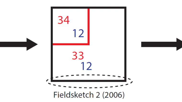
At the start of the registration programme, all parcels and boundaries were initially mapped. Since then the cadastral registration have been subjected to many changes because of dynamics in people-to-land relationships. These changes are recorded on new field documents, reporting only the new established boundaries. As a result, a parcel’s survey data is dispersed; retrieving the correct survey takes several steps, as it is demonstrated by the encircled boundary in Figure 1.

Parcel identifiers
The relation between field documents and the cadastral map is expressed by a parcel-oriented number. All parcels on the cadastral map are given a unique parcel identifier which corresponds to the parcel boundary representations on the field documents. Every modification to the parcel’s extent results in one or more new parcel identifier(s), and this is updated on the cadastral map. The actual changes in the extent are recorded on the field documents, on which both the expired parcel identifiers and the new parcel identifiers are noted. These notifications allow and enable the reconstruction of the history of a parcel and its related boundaries.
Types of survey data
The field documents have evolved over time in line with technical developments. In former times field documents were paper-based reports on which the boundary locations were recorded in terms of distances and bearings to terrain objects such as buildings. Nowadays, GPS equipment enables high-precision measurements to be input straight into the coordinate reference system and stored in digital files. This has led to wide variety in the cadastral registration system and different types of survey data for boundaries.
Complex link
Boundaries do not have a unique identifier (only a database identifier), and matching the correct survey data on a field document to its related boundary on the cadastral map requires human intervention and expert knowledge. This complication is strengthened by the cadastral registration dynamics: parcels are split when a part of a parcel is sold, or parcels are merged following land consolidation. This results in a very complex link between field documents and the parcels in the cadastral database over time. This fragmentation is demonstrated in Figure 2.

Survey and Representation Package
The ‘Survey and Representation’ sub-package has a special focus on geodata acquisition and the infrastructure of cadastral properties. The sub-package facilitates a structure to store and manage all related objects, such as spatial sources and spatial data (Figure 3). The sub-package consists of four different classes and it feeds into the spatial unit package.

Extended data model
The extended data model is illustrated in Figure 4. Since it is applied in The Netherlands, all classes are marked with the prefix ‘NL_’ and it uses the ‘Survey and Representation’ sub-package as a template. The most elementary requirement of connecting the field documents to the cadastral map is covered by the general structure of the sub-package with the LADM classes NL_SpatialSource, NL_Point, NL_BoundaryFaceString and NL_Parcel. The different classes include a unique identifier, where each object in the model is considered as a unique object. This makes it possible to refer survey data to specific boundaries or individual points. Therefore, survey data can be derived much more quickly and unilaterally. Further extra descriptions can be added to the objects in order to distinguish different types of objects, like topography, auxiliary lines or administrative boundaries.
Boundary relations
If a cadastral boundary runs (partly) along the edge of a building, the relation between both lines can be declared by the statement of the class NL_RequiredRelationship; ‘overlaps’. A second application of this class is to relate various spatial sources to an object with the statement ‘equals’.
History
In the LADM many classes are inheriting the superclass ‘VersionedObject’; this superclass enables the recording of all changes to an object over time. This facilitates the various adjustments of objects and observations. NL_SpatialSource is the only class which does not inherit the VersionedObject class, since spatial sources represent events. These events are the ‘suppliers’ of history for other objects.
History management is also implemented in the data model via self-associations, i.e. an object can refer to a previous (earlier) object. This facilitates the representation of cadastral dynamics in parcels and boundaries. Points have a self-association too, since in some ways they refer to other points. This is the case when GPS points are measured at random places and intersection points are created with a boundary’s starting points and ending points.

Concluding remarks
This article has highlighted the current issues of cadastral map and field documents in The Netherlands. The increasing complexity in the relationship between survey data and the cadastral map needs to be eliminated. A solution is proposed by the design of an own data model, which uses the LADM sub-package ‘Survey and Representation’ as a template. This data model creates a direct link to all different cadastral objects. The data model facilitates an overview of the survey and mapping quality of all boundaries and enables a much better accessible portal for survey data. The improved relationship between survey data and the cadastral map creates many opportunities for better expectancy, accessibility and usability of the cadastral map, e.g. more dedicated communication about the quality of boundaries or by generating user-friendly and custom-made information documents for ‘do-it-yourself’ reconstruction. The final ambition is to improve the geometrical quality of the cadastral map in such a way that it has a corresponding quality with the field documents to meet users’ expectations. This data model is a first step in that process.

Value staying current with geomatics?
Stay on the map with our expertly curated newsletters.
We provide educational insights, industry updates, and inspiring stories to help you learn, grow, and reach your full potential in your field. Don't miss out - subscribe today and ensure you're always informed, educated, and inspired.
Choose your newsletter(s)


