Airborne Dual-band Radar for Cadastre
Fit-for-purpose Approaches Are Possible Based on InSAR Technologies
The issues of land ownership and land use rights are high on the Global Agenda 2030. 50% of the Sustainable Development Goals are land-related. A very rough estimation for reaching these goals with traditional cadastral data acquisition approaches amounts to over 500 years of cadastral survey work. This clearly illustrates that breakthrough techniques will be necessary to meet the targets. Read on to learn more about the possible approaches based on InSAR technologies.
(By Dieter Lübeck, Bradar, Brazil)
A well-known approach for surveying large areas in a short space of time is airborne or space-borne remote seing. In fit-for-purpose approaches for land administration, printed imagery is used in the field for boundary identification in a participatory way. But can radar image data support the mapping of cadastral boundaries in an efficient way? A promising new approach in this area is using airborne dual-band (X-band and P-band) Interferometric Synthetic Aperture Radar (InSAR). Due to the known advantages, such as cloud penetration, sunlight independency and foliage penetration, radar imagery has increasingly been used for large-scale mapping and monitoring over the last decade.
Technology
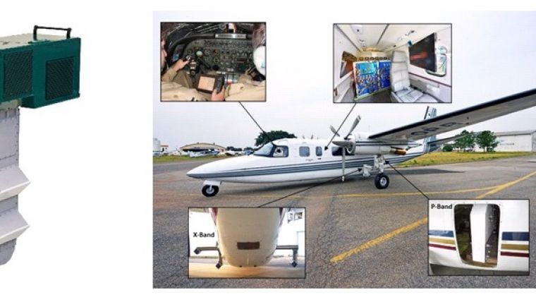
Bradar’s airborne dual-band radar uses the X and P bands because they have the most complementary mapping characteristics. While the X band, with 3cm wavelength, maps the visible surface only, the P band, with 70cm wavelength, penetrates the foliage and allows the topography beneath the vegetation to be mapped. In the past, the main application of this technology was in interferometric phase processing for topographic mapping. Nowadays, the high-quality images from the amplitudes are opening up new horizons for planimetric feature extraction in scales up to 1:5,000, with the major advantage of cloud penetration and a wide mapping swath. The airborne radar system mentioned above combines all these characteristics and has already mapped an area of approximately 2.3 million square kilometres in Central & South America and Europe (see Figure 1).
Detecting fences
New studies performed by Bradar in Brazil have shown that the P band is not only capable of detecting boundaries demarcated by roads, rivers or vegetation, but also of detecting very fine wire fences which are commonly used in South America for demarcating land (see Figure 2). Applying this technology to support land registration and cadastral survey could be the solution for speeding up registration processes and helping to protect local populations against land grabbing.
Surprising results
Tests showed that the feature extraction of these fences can be realised with a high planimetric accuracy of up to 20cm in the P-band imagery (see Figure 3), which meets the requirements for supporting land administration in many developing countries. This surprising result can be achieved because the horizontal wires of the fences act like small antennas for the horizontally polarised P-band radiation. Since the fences are close to the ground, one can observe the so-called double-bounce effect of the wave back to the radar. Due to this effect the signals from all the horizontal wires of the fence combine into a sum total, and the fence appears in the image as a single line in the position of its vertical projection on the ground. Figure 4 shows an example of a P-band image with a fence network in a deforested area. In addition to the fences, other important features can be extracted such as woodland, roads, buildings, single trees and animals.
Applications
The radar imagery can be applied for integral cadastral boundary detection. Most of those boundaries are visible features, defined by roads, vegetation, rivers, fences and buildings in a very efficient way. Even rivers concealed by vegetation can be extracted. Figure 5 shows an example of an area in Brazil, including orthoimages X, P, X/P colour, and extracted boundaries overlaid on the P-band image (from left to right). Additionally, digital terrain models and/or surface models can be provided by applying interferometric flights to obtain altimetric information for generation of contour lines and extraction of drainage networks, including 3D simulations. This information is useful in support of not only land administration but also rural development, infrastructure projects, forest certification, rural environmental cadastre, risk mapping, area preservation, land use mapping and topographic mapping, among many other applications.
Change detection
The radar imagery has another big advantage for change detection, namely the repeatability of illumination geometry between different flights. As opposed to optical images, this allows a systematic comparison of the images supported by image processing software. Changes in land use can be detected automatically in any type of construction. This provides the option to reconstruct ‘replaced’ cadastral boundaries.
Experiences in Brazil
The applicability of this approach has already been demonstrated in two technical feasibility studies: one close to the hydropower station of Belo Monte and the other in the district of São José dos Campos. Planimetric accuracy was measured with differential GPS at both sites. Wire fences presented an RMSE error of around 20cm and water boundaries of around 1m.
The radar survey will not completely replace ground survey, but it allows the ground boundaries to be generally defined and vectorised before going out into the field. In Brazil, for example, the interview with the landowner, the review of land boundaries and the demarcating must be carried out as a ground survey. Using radar imagery could reduce the amount of effort and time involved in conventional fieldwork by a magnitude of three to five.
Fit-for-purpose approaches
Agencies in Brazil and Latin America had not previously considered remote sensing for land administration development, and current governmental regulations do not even allow it without performing a complete ground survey. Radar surveying can speed up such a ground survey and serve as a control method. In fit-for-purpose approaches, radar imagery is now being considered as an effective way of collecting cadastral boundary data quickly and cheaply. Printed imagery can be taken into the field to compare automatically extracted features with actual cadastral boundaries. Those boundaries can be marked with a pen on top of the image. Back in office, the polygons for spatial units (parcels) can easily be identified and fed into the database with the required accuracy.
Author
Dieter Lübeck holds a degree in cartographic engineering from FH München, Germany. He has been working with radar remote sensing since 1998 and is an expert in airborne radar mapping applications. He is the general manager of the remote sensing division at Bradar, Embraer – Defence and Security Group in Brazil.
Email: dieter.luebeck@bradar.com.br

Value staying current with geomatics?
Stay on the map with our expertly curated newsletters.
We provide educational insights, industry updates, and inspiring stories to help you learn, grow, and reach your full potential in your field. Don't miss out - subscribe today and ensure you're always informed, educated, and inspired.
Choose your newsletter(s)


