Fulfilling the Land Surveyor’s Wants and Needs
Marlyn: the Go-anywhere Mapping Solution Made by Surveyors, for Surveyors
Geospatial information gathered by unmanned aerial vehicles/systems (UAVs/UASs or ‘drones’) is now the driver for business success across many industries and applications. To develop the right tool for this data collection, Atmos UAV had a different approach compared to other commercial drone manufacturers. Rather than focusing just on the product itself, the team was mostly interested in the product fit. After conducting more than 500 interviews with end users, company owners and project managers during the last six years, the company developed Marlyn, a mapping and land surveying solution that meets the industry’s wants and needs.
The necessity of VTOL and the desire for high wind resistance
Up until recently, professional end users could choose from two different UAV categories: multirotors and fixed-wing drones. Although fixed-wing solutions offer faster and longer flights, according to operators the damaging belly landings make them a no-go. Furthermore, the availability of space for such a landing is considered a luxury most of the time. On the other hand, multirotors are more flexible with their vertical take-off and landing (VTOL) ability, but they lack endurance and speed. As a result, developing a combination of the two proved to be necessary in order to meet the modern land surveying requirements.
Originating from TU Delft and its highly recognised faculties of aerospace engineering and applied Earth sciences, the founders of Atmos had all the resources needed for this challenge. The team not only focused on designing a robust cross-over by taking the best of both worlds, but did so by considering one of the most demanding desires of end users: wind resistance.
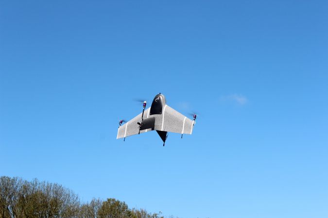
The end result, Marlyn, takes off and lands vertically, even in confined spaces, while flying quickly and efficiently like an aeroplane (Figure 1), thus offering an unprecedented speed of operations. The unique design of the patented hardware enables the drone to withstand wind speeds of up to 6Bft (45km/h), with its four electric motors ensuring controlled and steady hovering.
The need for high accuracy and precision
There was a strong consensus among all the professionals interviewed regarding the need for high-quality data that will make the post-processing easier and the outputs (such as digital elevation/surface models and orthophotos) more accurate (Figure 2). After all, for most of the end users, their work is not finished when the drone has landed. Capturing high-resolution images and having precise geotagging is of the utmost importance when converting the aerial imagery into point clouds, ideally as quickly as possible.
To that end, and by taking account of the fact that the optimal integration of payload components and platform is essential, the Atmos engineering team tested multiple sensors before eventually deciding to equip Marlyn with the SONY QX1. The QX1 is an industrial-grade camera that combines an APS-C-sized Exmor CMOS image sensor with a BIONZ X processor to produce high-resolution images (5,456 x 3,632 pixels). The balanced trade-off between resolution and light sensitivity gives the advantage of a longer operational window so that professionals can map without limits. The team is also working on integrating multispectral and thermal cameras for agricultural, environmental and thermal inspection applications.
With regards to geotagging, using ground control points (GCPs) often appears to be the least appealing option for surveyors as the process requires a lot of time in the field and more complex post-processing. To reduce costs and save time, post-processed kinematics (PPK) was chosen over both GCPs and real-time kinematics (RTK), as PPK is a more reliable solution that does not require an extra data link. A full-PPK module guarantees accurate image georeferencing as the satellite positioning is fully augmented with supportive base station/VRS information. By integrating Septentrio’s high-end PPK module, all the GNSS bands are stored and used to achieve full-PPK accuracy, resulting in centimetre-level accuracies.

The demand for reliability and efficiency
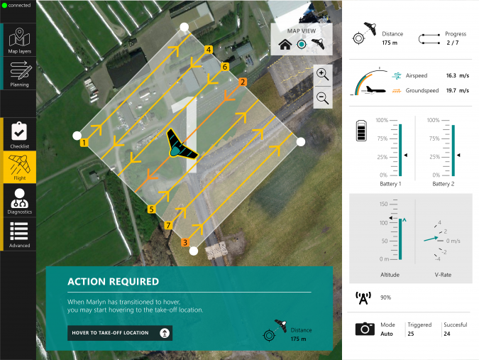
According to UAV operators, reliability and efficiency are major concerns when selecting the right tool for a mapping project. Professionals across industries are seeking a solution that can offer them peace of mind and full control during operations. To satisfy these demands, Atmos put a lot of effort into its in-house- developed autopilot, the flight planning and control suite MarLynk (Figure 3), and its dedicated smart battery system.
The autopilot software makes the planning intuitive and straightforward, and provides the user with real-time information during the flight, such as position, altitude, battery consumption, wind speeds, project progress and more. After completing a quick checklist, the land surveyor defines the boundaries of the region he/she wants to map, specifies ground resolution and overlap, and takes off safely with the push of a button. Users can now enjoy the hands-off experience of a fully autonomous flight from take-off to landing.
To further increase the efficiency and reliability of the drone, a dual-battery system is used in which one battery functions as a failsafe for the other. The two redundant smart batteries are closely monitored in terms of remaining energy capacity, voltage and cell temperature. Marlyn’s smart power board can recognise any inconsistency and initiate a predefined safety routine to land automatically.
The desire for a go-anywhere solution
Besides the reliability, many respondents also highlighted the desire for a land surveying tool that can be easily transported, deployed and handled. According to the feedback, depending on the project, the system must be suitable for shipping as air freight, fit into a small car and be easy to carry around in the field. Surveyors usually perform mapping projects in difficult-to-access areas so a safely portable UAV is necessary.
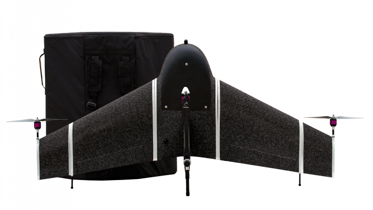
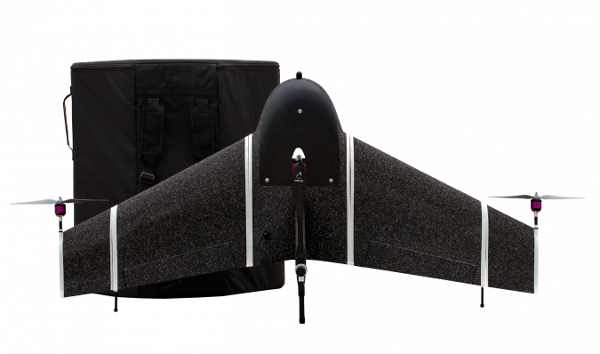
With these goals in mind, Atmos focused its R&D and product design efforts on the product’s portability using detachable wings and expanded polypropylene (EPP), a highly durable constructive foam, as a means to an end. EPP is a material with a unique range of properties including high energy absorption, thermal insulation and impact resistance. EPP has not only been used for the protective inlay of the flight case and the associated backpack (Figure 4), but also for the drone itself. This provides compact storage that results in increased endurance and certainty during projects and transportation.
Conclusion
When considering mapping and land surveying projects, a reliable and easily portable VTOL tool with full-PPK accuracy appears to be the best solution. A high-end combination of hardware and software is needed to fulfil today’s requirements.
Atmos is keen on building strong relationships with clients and partners based on mutual feedback, in an effort to continuously improve its offering and provide professionals with go-anywhere solutions tailored to their wants and needs.
Further Reading:
Use-case: Marlyn provides crucial data for endangered wildlife research

Value staying current with geomatics?
Stay on the map with our expertly curated newsletters.
We provide educational insights, industry updates, and inspiring stories to help you learn, grow, and reach your full potential in your field. Don't miss out - subscribe today and ensure you're always informed, educated, and inspired.
Choose your newsletter(s)


