High Resolution
3D Imagery from Space
The last decade has shown a series of developments triggering intensification of the use of satellite imagery for a multitude of applications. These developments include, among many: reduction in cost of launching satellites into orbit, improvement in revisit time for capturing a scene and boosting ground sample distance to up to 50cm; a spatial resolution that challenges aerial photogrammetry. Among the greatly in demand products derived from satellite data are Digital Elevation Models (DEM). In tandem with the new product survey on Very High Resolution Satellite Imagery (see our website), the author here discusses the possibilities of very high-resolution optical and radar imagery for creating DEMs. Features of the RapidEye constellation launched in August 2008 are also discussed.
Suddenly it was there: the ‘3D image'. It's a term differently interpreted by different people. Some consider a 3D image to be two overlapping images taken from different viewpoints. For more than a century photogrammetrists have coined the term ‘stereo image' for image pairs capturing the same scene from different viewpoints. So why change a perfectly serviceable label? Another interpretation of ‘3D image' is a digital elevation model (DEM) draped with an aerial or satellite image. And this is what we, in the context of this article, would like to adopt as a 3D image. Many geo-data acquisition technologies are available to create DEMs, including ground-based capturing using Global Navigation Satellite Systems (GNSS), airborne Lidar, digitisation of contour lines printed on topographic maps, airborne stereo-imagery and overlapping satellite imagery. We will focus on the latter. DEMs created from imagery recorded from space can be created either from passive optical or active radar sensors.
Optical Sensors
Ikonos, QuickBird, GeoEye and OrbView have onboard optical sensors recording visible and near infrared bands. They provide imagery of which the ground sample distance (GSD) is one metre or better; this type of image is said to be of very high resolution (VHR). GSD together with 11-bit radiometric intensity range and the capability to create overlapping images allows highly automatic large-scale DEM generation. Overlapping images can be collected in-track, meaning during the same pass, across track and mixed satellite stereo configurations, ‘mixed' here referring to imagery stemming from different satellites combined to create pairs of stereo imagery. The acquisition geometry of overlapping images, which is mainly determined by the base-to-height ratio (b/h), greatly impacts on elevation accuracy: the greater the b/h, the higher the accuracy. On the other hand, a smaller b/h reduces the effects of occlusion when, for example, a house becomes concealed by an office building and is thus rendered invisible.
The occurrence of occlusion in satellite images is one of the major impediments to the creation of 3D images of urbanised areas; their b/h is optimised for rural areas. In addition, as manual data acquisition is often too time-consuming and hence expensive, researchers and developers are investigating the suitability of stereo-matching techniques such as least-squares matching and dynamic programming. The results would appear acceptable for urban scenes. However, occlusion, abrupt height discontinuities, and the wide variety of shape, size and density of objects render troublesome the automatic generation of digital surface models (DSM) of urban areas.
A study of Ikonos and QuickBird carried out by the PASCO Cooperation Tokyo, Japan, revealed that good base-to-height ratio was the decisive factor for high accuracy; the type of stereo configuration - in-track, across track or mixed stereo - appeared subordinate.
EROS A and B
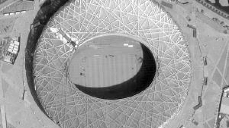
We have discussed the DEM generation capabilities of VHR imagery. Satellite sensors tagged ‘high-resolution' are also capable of creating stereo-images. For example, the Earth Remote Observation Satellite (EROS) A, launched in 2000, and EROS B launched in 2006, both operated by Netherlands Antilles firm ImageSat International NV, produce overlapping images of a scene during the same pass. The scene dimensions of EROS A stereo-pairs is 14x14 km2 while for EROS B the scene size starts at 7 x 7km2 and ends at 21x21km2. Both EROS satellites capture only the panchromatic band, no multispectral bands, and the GSD is 1.9m. Pictures of two famous stadiums shown in Figure 1 demonstrate the high level of detail visible in EROS images. The user community for EROS imagery and derived products and services primarily concerns governments and their defence forces interested in national security and intelligence applications.
Radar Sensors
Satellite images have reached levels of geometric accuracy and spatial resolution that were, up to a few years back, only achievable with aerial images. A GSD of around 50cm, provided by GeoEye, Quickbird and WorldView, corresponds to the information contents of 1:25,000 analogue aerial photos. This means VHR optical satellite images provide a viable alternative for creating DSMs and DEMs in countries where aerial images and airborne Lidar data are not nation-covering.
A clear disadvantage of optical images becomes apparent when the DEMs have to be available quickly, in the immediate aftermath of an area being slammed by a far-reaching event such as an earthquake, flood or other disaster. Satellite radar images are most valued when rapid accessibility is vital, because their recording is, in contrast to optical imagery, independent of available sunlight, and microwaves emitted by the system are able to penetrate haze and clouds. On the other hand, manual interpretation of radar images is more difficult than that of optical images. The pixel values represent intensity of the return signal, which depends on roughness and dielectricity of objects hit, and on their shape and size.
TanDEM-X
The only VHR radar sensors onboard orbiting satellites are the identical TerraSAR-X and TanDEM-X (TerraSAR-X add-on for Digital Elevation Measurement) launched respectively in 2007 and 2010. Both satellites, equipped with synthetic aperture radar (SAR), were put into orbit first and foremost to generate homogeneous DEMs with an elevation accuracy of better than 2m covering the entire land surface of the globe: 150 million km2. By 2014 this world-covering DEM will be completed as a raster database of grid size 12x12m2. The twin radar satellites can vary their mutual distance from a few kilometres down to less than 200 metres, enabling flexible baseline selection; virtual steerage is essential to avoid collision! This excellent example of space technology has been realised in a partnership between the German Aerospace Center (DLR) and Astrium. Commercial marketing of the images, derived products and services, is done exclusively through Infoterra GmbH.
RapidEye
In the month we published our previous product survey on high-resolution satellite imagery (August 2008), Germany-based RapidEye launched its constellation of five identical small satellites producing high-resolution images acquired by pushbroom multispectral scanners. The satellites are equally spaced in a sun-synchronous orbit. This constellation acquires four million km2 images every day. The recorded GSD of 6.5m is re-sampled to 5m. The images are mainly used for agricultural applications. Further fields of application include security and emergency, forestry, environment, and energy and infrastructure. The sensors mounted in each of the five satellites collect the conventional spectral bands: blue (440-510nm), green (520-590nm), red (630-690nm), red-edge (690-730nm) and near-infrared (760-880nm). But in addition to these four, like WorldView-2, orbiting at an altitude of 770km and launched in autumn 2009, the RapidEye sensors record the red-edge band (680nm to 740nm), which is sensitive to the chlorophyll content of vegetation. This makes it suitable for stress or crop-nutrition diagnostics, while the same spectral band also allows discrimination between vegetation types such as irrigated (parks) and non-irrigated grasslands.
Product Survey on High-resolution Satellite Imagery

Value staying current with geomatics?
Stay on the map with our expertly curated newsletters.
We provide educational insights, industry updates, and inspiring stories to help you learn, grow, and reach your full potential in your field. Don't miss out - subscribe today and ensure you're always informed, educated, and inspired.
Choose your newsletter(s)


