How geospatial AI leads to smart urban ecosystems
The possibilities of geoAI for monitoring Mother Nature are limitless according to Dr Nadina Galle, an ecological engineer and entrepreneur dedicated to applying emerging technologies.
The use of satellite imagery to manage the health of trees in cities improves urban ecosystems. By combining traditional methods with other geospatial technologies, such as remote sensing, and artificial intelligence to achieve ‘geoAI’, it is possible to detect and classify features even faster and more accurately. GIM International spoke to Dr Nadina Galle, an award-winning ecological engineer and entrepreneur dedicated to applying emerging technologies, to learn more about the seemingly limitless possibilities of geoAI.
You have developed a method to determine the health of trees in cities using satellite imagery. How does this work?
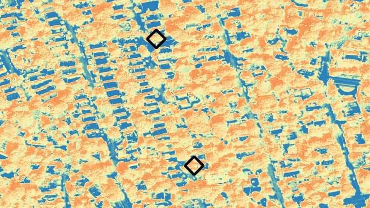
Since the launch of the first Landsat satellite in 1970, research has verified the use of satellite data in quantifying aspects of vegetation productivity, health and change. A vast array of spectral vegetation index (SVI) algorithms have been developed for a variety of functions, all according to specific mathematical expressions that combine visible light radiation, mainly from the green spectra region (from vegetation) and non-visible spectra, to obtain proxy quantifications of vegetation health. I wanted to develop a new tool for urban ecologists and arborists: an instrument that could accurately, efficiently and, most importantly, proactively determine the health of trees and their soils in cities. I combined soil samples with spectral data to create an SVI. This index is a number between -1 and 1 and tells us something about the health of a tree. Everything up to 0.2 is a vegetation-free surface, such as asphalt or buildings. Everything above 0.2 is vegetation. The closer to 1 a tree is, the healthier it is. I then correlated these SVI values with my soil samples and found significant positive correlations with soil properties like bulk density and luminance, and negative correlations with total carbon and active fungi/bacteria. While more research is needed, the study indicated severe soil disturbance and its possible effects on tree health, and presents a compelling proof-of-concept for using satellite-based SVIs to provide timely data on soil-health properties at the individual tree level.
Which other geospatial methods could be used to monitor Mother Nature?
Spectral data is an important geospatial method to monitor the health of vegetation and, potentially, soil. However, I am increasingly inspired by the potential of ‘geoAI’ – the combination of geospatial technology and remote sensing imagery with artificial intelligence. With geoAI, we can develop algorithms to detect and classify features with a much higher degree of accuracy and speed than traditional methods, revolutionizing the geospatial sector. Identifying buildings, roads, lakes and even trees is just the beginning. The possibilities are limitless.
In 2019, you won the Copernicus Masters competition with the Green City Watch application, TreeTect. Can you tell us more about this project?
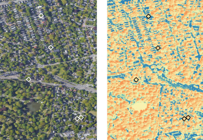
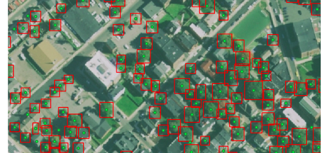
GeoAI is at the heart of TreeTect (from ‘tree detection’), which helps cities to create updated, digital tree inventories: the foundation of any effective urban-forest management plan. By making use of very high-resolution (VHR) satellite imagery, TreeTect is able to scan vast areas of city terrain to pinpoint individual tree location, size, shape and condition. In the past, satellite imagery used for urban green space analysis had a resolution of over 10m², which is helpful if you want to locate green patches in a grey city but not so helpful in clarifying what makes up those green areas. The satellite imagery TreeTect relies on measures down to 30cm2 of land. The TreeTect algorithm can then figure out not just where the city’s parks are, but whether it is looking at a green tree, shrub, bush or a green garden shed. This means we are able to proactively manage urban trees in near real time.
In the TreeTect pilot, we combined high-resolution satellite imagery with our algorithm to identify over 2,000 trees in a neighbourhood of Boston. With our algorithm, city staffers were able to catalogue tree attributes and health (we used three different SVIs). The city of Boston will use the digital inventory to improve tree equity and anticipate tree maintenance tasks instead of relying on 311 calls and manual inspections.
Now that ‘smart city’ is becoming more than a buzzword, is it perhaps time to create a green equivalent to improve urban ecosystems?
Yes! The ‘Internet of Nature’ (IoN), a concept I developed during my PhD, bridges the gap between ‘green cities’ and ‘smart cities’ to explore the future of ecosystem management in an age of rapid urbanization and digitization. The IoN applies emerging technologies to improve the health of urban ecosystems and will provide ‘ecosystem intelligence’ to design, manage and connect urban ecosystems. It is my hope that the IoN will continue far beyond the academic and into the hands of avantgarde ecologists, cunning planners, talented engineers and forward-thinking tech entrepreneurs, onto the cutting room floor, at city council meetings and in classrooms for both young and old.
Which role could you envisage the geospatial sector playing in building ‘smart city ecosystems’?
Since the 1960s, geographic information systems (GIS) have helped millions of people identify problems, monitor change, understand trends and set priorities for solutions across sectors, around the world. In cities, a GIS enables spatial analysis and modelling which can contribute to a variety of critical urban tasks. Now, GIS is going beyond analysing imagery and moving into interpreting imagery. We’re not only receiving increasingly more data on a daily basis, but we’re also becoming able to glean a lot more information from that same data. This level of real-time data collection and AI-based interpretation is a cornerstone of the IoN and necessary to meet the needs of the cities of tomorrow.
Dr Nadina Galle is an award-winning ecological engineer and entrepreneur dedicated to applying emerging technologies to improve the health of urban ecosystems for future generations – what she calls the ‘Internet of Nature’ (IoN). Nadina specializes in the translation of scientific discovery into public knowledge. She is an environmental scientist, tech enthusiast, published academic author, keynote speaker and advisor to start-ups and universities. Her work has been recognized by National Geographic, The Next Web, TEDx, Newsweek, ELLE and the European Space Agency. In 2020, she was featured on the #ForbesUnder30 List for Science and Healthcare.

Value staying current with geomatics?
Stay on the map with our expertly curated newsletters.
We provide educational insights, industry updates, and inspiring stories to help you learn, grow, and reach your full potential in your field. Don't miss out - subscribe today and ensure you're always informed, educated, and inspired.
Choose your newsletter(s)


