Qatar University Launches Digital Qatar Project
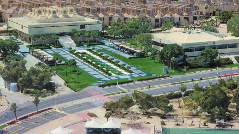
Qatar University (QU) has unveiled plans for the Digital Qatar Project. Drone imagery will be used for the purposes of aerial surveying at QU, with the participation of specialists from Qatar and international experts in the field of two-dimensional surveying. The project is being run by the university’s College of Engineering (QU-CENG) and is sponsored by Dolphin Energy.
Hassan Al-Emadi, Dolphin Energy’s general manager for Qatar, stated: “Investing in modern technologies will not only be of great value to the university’s faculty, students and experts, but will also help provide a digital infrastructure that will drive cultural change. Digital transformation is now a strategic imperative and we hope that this initiative will provide opportunities to practice enhanced technical innovation and implement business solutions in an efficient manner.”
Dr Khaled Kamal Naji, QU-CENG dean and project supervisor, commented: “The project is aimed at introducing the mechanisms of aerial surveying and investing in modern technologies through the use of remote drones to capture high-quality aerial images of Qatar University for the purposes of three-dimensional surveying.”
“The project will provide a high-quality digital model for Qatar University in three dimensions that facilitates the process of maintaining facilities within the university, linking them with facilities management systems, and providing three-dimensional maps for all faculties and students, and a large number of future applications,” he added.
Digital transformation policy
“The new model of Qatar University will provide an augmented virtual reality experience, which will be accessible to visitors to the Qatar University website. It will enable them to explore inside the university buildings and discover all the services provided by the university,” Naji concluded.
The project supports obtaining actual dimensions of the infrastructure with an accuracy of 3-4cm. The images from the aerial survey will be used to create 3D digital models of the facilities, which can easily be used later to connect with building information modelling (BIM) systems. This connection and conversion to 3D models is the first important step towards the digital transformation policy pursued by the State of Qatar aimed at establishing smart cities. In the future, it will be necessary to create digital models of all the country’s infrastructure to facilitate the process of linking those 3D models with building & facility management and maintenance systems.
A specialized group of engineers and technicians from several scientific departments have recently been trained at the QU College of Engineering in how to use the relevant technologies. The College of Engineering’s Digital Qatar initiative is regarded as an important project for digital transformation at Qatar University.

Value staying current with geomatics?
Stay on the map with our expertly curated newsletters.
We provide educational insights, industry updates, and inspiring stories to help you learn, grow, and reach your full potential in your field. Don't miss out - subscribe today and ensure you're always informed, educated, and inspired.
Choose your newsletter(s)


