SenseFly Unveils UAS for Precision Agriculture
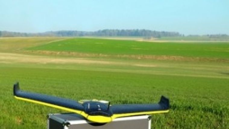
Swiss mini-drone manufacturer senseFly has announced the eBee Ag, a fully autonomous aerial imaging drone for precision agriculture applications. The UAV features a wide range of camera options and fully autonomous operation: flying, acquiring images, and landing itself.
The eBee Ag enables growers and crop consultants to become much more precise in their work, said Jean-Christophe Zufferey, CEO of senseFly. The detail provided by its customised cameras and its software’s index calculations allows customers to analyse crop conditions remotely and in high detail. This means less time wasted on manual checks and less reliance on low-resolution satellite images or costly aircraft shots. With the accurate and timely data the eBee Ag supplies, farmers can optimise their crop management and chemical usage – saving them time, saving them money and helping them boost their yields, he added.
Cameras
The eBee Ag features a range of camera options to suit different applications, from biomass estimation to yield monitoring and leaf area indexing. It is supplied with a customised Canon S110 NIR, however customers can also choose a customised S110 RE (red edge) version, a S110 RGB, or the Airinov multiSPEC 4C (offering four distinct bands with no spectral overlap).
Software
The eBee Ag is supplied with two advanced software packages: eMotion 2 for flight planning and control; and Postflight Terra 3D photogrammetry software for post-flight image processing and analysis. Postflight Terra 3D can be used to produce false-colour orthomosaics and 3D models. It also includes a handy index computation tab, which allows customers to select a band, calculate NDVI, or input custom formulas in order to create the exact maps they require.
With its maximum flight time of 45 minutes, the eBee Ag can photograph areas of up to 1,000ha (2,470 ac) in a single flight. Its default 12MP NIR camera is capable of shooting aerial imagery at down to 2cm (0.7in) / pixel. These images are then easily transformed into false-colour orthomosaics using Postflight Terra 3D software, with accuracy of down to 3cm (1.18in). This performance brings farmers the data they need to monitor crops more precisely, feed other precision agriculture technologies, and continue improving their management decisions.

Value staying current with geomatics?
Stay on the map with our expertly curated newsletters.
We provide educational insights, industry updates, and inspiring stories to help you learn, grow, and reach your full potential in your field. Don't miss out - subscribe today and ensure you're always informed, educated, and inspired.
Choose your newsletter(s)


