
The New Era of Mobile Scanning
GIM International Interviews Felix Reinshagen, CEO of NavVis
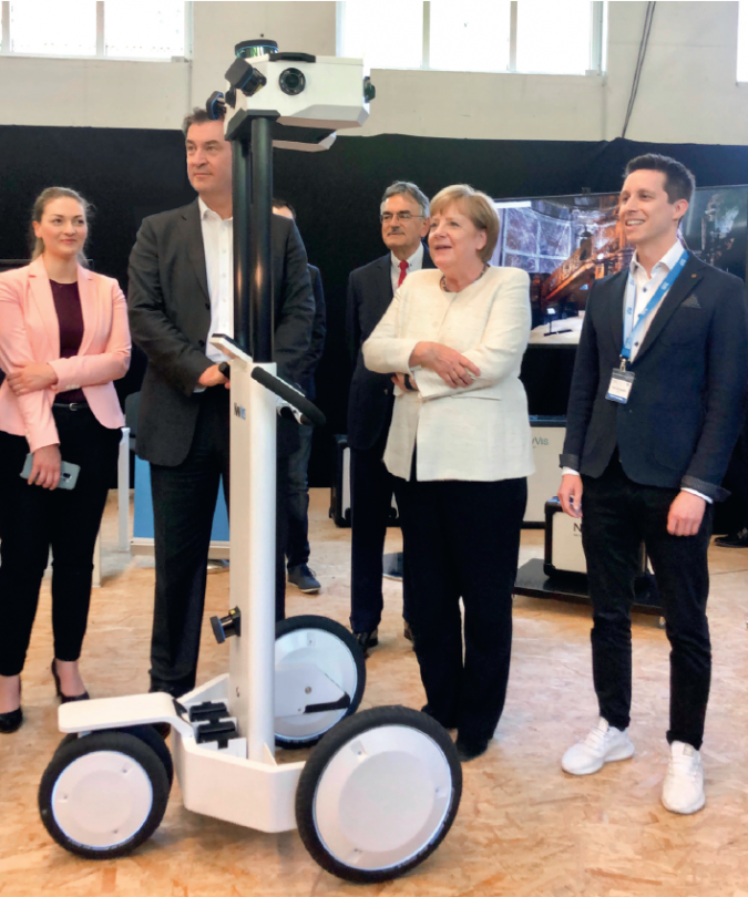
Indoor mobile mapping is well past the tipping point and is about to go mainstream. In this interview, Felix Reinshagen from NavVis shares his views on the future, including his confidence that there will be plenty more developments in automatically generated assets from reality capture, and how 3D scanning and the geospatial industry are set to impact the world in many respects. Felix Reinshagen is co-founder and CEO of NavVis, a company that was set up with the objective of bridging the gap between outdoor and indoor digital maps.
Do you see laser scanning becoming a commodity in the near future, or will it remain a specialist job with large equipment? And how is NavVis preparing for that future?
When it comes to the sheer availability and amount of laser scanning that’s being done, it will certainly become a commodity. But we’ll also see a broader sweep in the quality of laser scanning being carried out, and it will be very specific to the different jobs and their requirements. For example, there will be lower-accuracy laser scans conducted by people with smaller, less expensive devices and with less of a technical background. But at the same time, there remains a need for high-quality and very precise laser scans. That will stay a specialist job for the foreseeable future, even though it will also be made easier and faster using tools that do part of the quality assurance semi-automatically.
One of the core technologies to make things easier is SLAM (simultaneous localization and mapping, Ed.), where part of the registration of different datasets is done automatically and where you have better guidance and tools like quality maps and graphical user interfaces to better support users throughout a project. But the same technology isn’t limited to SLAM-only devices; it’s also in mixed devices, which we can see in laser scanning equipment that use auto-registration and self-levelling.
In terms of how is NavVis is preparing for this future, we’re setting the pace. We were one of the first to introduce SLAM-based scanning devices that really extended the range of areas where SLAM could be used. In the past it was generally tied to only low-quality scans. We’ve made SLAM much more accurate, so it can serve a much wider segment of the industry, and we’ve put a lot of effort into usability and integrating the scanning workflow with the traditional surveying workflow. For example, use of our SLAM anchors (aka ground control points) still requires some specialist knowledge but it’s a lot faster and alleviates some of the difficulty, plus you can do it with less qualified personnel. The real expertise in the future will rely on two things: first, knowing and deciding what kind of equipment you need, and then combining different ways of scanning to deliver more comprehensive data which at the same time has exactly the right quality at the perfect cost point. Today we see a lot of over-delivery of quality, with excessive cost, file sizes and level of detail, and that’s not necessarily a good fit either.

What are the main challenges in obtaining larger and more accurate point clouds, and how is NavVis tackling them?
For surveyors or laser scanning professionals using a terrestrial laser scanner to create very large and highly accurate point clouds, the challenges are that the scanning process is very slow and a massive amount of data is being generated. A terrestrial laser scanner (TLS) just doesn’t scale very well. The solution we’re offering is a next-generation SLAM-based mobile mapping device that is capable of sub-centimetre accuracy, is much more scalable, and takes a fraction of the time to complete a job. The time advantage of SLAM-based devices will kick in depending on the number of square metres that need scanning. The benefits aren’t immediately apparent for just one room, but if you’ve got to scan five floors or even five buildings, then the advantages of SLAM-based scanning will quickly accumulate. That’s scalability.
Besides making SLAM more accurate, it’s also extremely helpful that we can tie our mobile mapping devices in to more traditional surveying methods. We can incorporate ground and wall anchors, so you can guarantee a baseline quality to your measurements and adjust the quality to the job requirements. If you really want to do a very simple scan with only local accuracy in a small environment, then you might not need SLAM anchors at all. If you want large, high-quality point clouds, then it’s the ability to sync up advanced SLAM-based devices with ground control points that makes our technology so unique.

How will you use the recently received new funding to further develop the company?
The additional €20 million in funding provided by the European Investment Bank comes at the right time, when the SLAM-based scanning market and the digital twin market are rapidly expanding. We’ll use it to double down on the continued development of our core technologies and further build our global presence.
What are the main challenges in mapping indoor and other GNSS-denied environments?
The difficulty in mapping GNSS-denied environments is that you don’t have an absolute reference, so you need to have another means of creating very reliable or accurate reference points indoors. You’ll need a SLAM device that’s either a lot more stable and provides more accuracy in an order of magnitude, or you’ll need a device that’s capable of tying into measurement points that were projected into the GNSS-denied area for higher accuracy. Our scanning hardware is capable of both; our devices are very resilient against drift, much more so than other SLAM devices on the market, and they can tie into these projected reference points.

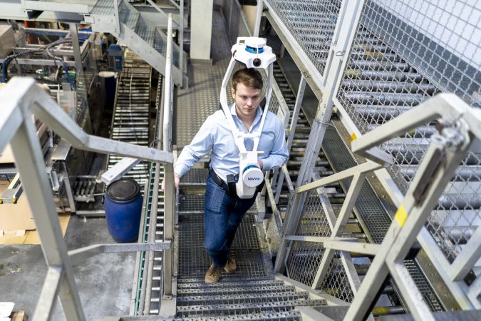
Now that you have gone from a large cart to a more mobile set-up, what’s the next step in laser scanning?
From my point of view, there are a couple of directions which are inevitable. One will be a greater importance of software than hardware. Over the lifetime of the NavVis M6, for example, it became a lot more accurate and a lot cleaner in data quality than when it was first launched, and we’ve delivered a couple of nice additional features in terms of usability. We’re already setting the quality standard for dynamic mapping, but you can expect to see similar additional improvements in data quality and usability over the lifetime of NavVis VLX.
Even further down the line there will be further advances in miniaturization, and SLAM-based scanning in general will become much more mainstream, occupying a much larger market share. It won’t entirely replace other forms of scanning, but we believe it will be the dominant form in the long term as devices become smaller and easier to operate. They’ll also provide more intuitive feedback – for example, the right moment to make a loop closure and so on – making laser scanning more convenient and accessible for non-specialists and allowing laser scanning to conquer many new fields, workflows and verticals.
Sensor technology is making systems smaller and smaller. How is this impacting on your laser scanning systems?
Sensors are certainly getting smaller, and they’re becoming more affordable too. Although the accuracy of these smaller, lower-end sensors hasn’t really improved so far, we can reasonably assume that they’ll catch up in this respect as well. In the future you’ll have better and cheaper sensors which are smaller than today, powered by more advanced software. You’ll be able to build devices that are at least as good as the best of today’s SLAM-based devices, but they’ll be even more affordable – today the cost is largely still driven by the cost of sensor technology – and they’ll have smaller form factors. Perhaps the bigger question is whether high-end laser scanning technologies are going to make the leap onto a smartphone or tablet, because if they move do then you’d potentially have a scanner with you at any time. But I don’t see that happening just yet, because even solid-state Lidar requires a lot of energy, and I don’t think that there’s a viable use case for the average person needing the capability to conduct large, very accurate scans.
What about outdoor scanning? Do you see a role for NavVis there?
NavVis technology was originally designed for indoor use, because indoor mapping at scale really was an unsolved problem. We started from the assumption that 10cm accuracy in the first-generation NavVis M3 was adequate for mapping. But after we mastered that, our customers then requested the same speed and cost but with survey-grade quality. This gap has been mostly closed and we’ve learned, to our surprise, that NavVis M6 and NavVis VLX are being heavily used outdoors. This is somewhat of a new development because we’ve traditionally positioned our devices for indoor scanning, but what we’re seeing is that the same quality is really appreciated for outdoor use cases as well. Innovative customers of ours are scanning outdoors not just between buildings, but also moving into applications like forestry and topography.
How do you make sure your Lidar solutions are user friendly and accessible for a broad audience of experts from different backgrounds?
We believe in user interfaces that are accessible and intuitive, and that’s where all our scanning devices are really pioneers in their field. You can monitor the point cloud not only as it’s being generated in real time, but also at the quality it’s being scanned. That makes a world of difference to a project. And of course, there’s a big advantage in the fact that you can just walk at your own pace and everything is scanned automatically. The GUI shows you exactly where you’ve been, what you’ve scanned and at what quality, and that’s a fundamentally different approach to a TLS. You can even open doors and move things around while scanning with NavVis VLX. Besides that, there are a lot of additional post-processing features that make it smoother for SLAM devices to deliver exceptional results. For example, two core elements of our user-friendly approach are the way our devices can read SLAM anchors or combine different scans in post-processing (NavVis scans and non-NavVis scans).
This appears to be the decade of digitalization in the construction industry. How much knowledge of geospatial technology do construction engineers have?
Knowledge is increasing. There was always some awareness about geospatial technology in construction, but it was very often isolated rather than being integrated with the building workflow and tied into a larger digital picture. Of course, geospatial technology requires a broad field of knowledge, and construction engineers already have to take many other things into consideration. It’s asking a lot for them to become experts in this technology as well. But I think the construction industry seems to be embracing digitization a lot more. It has been slow in comparison to other industries, making only minimal productivity gains in the past few decades. I believe that scanning will be one of the absolute core technologies which ensures that the construction process becomes more digitized, but that’s only a means to an end so it becomes more productive and efficient.
Geospatial technology will enable engineers to track their progress in much greater detail and with more precision than ever before. But for that to work, the hardware and software must be a lot easier to use because people on construction sites already have their own areas of expertise; they shouldn’t be required to be fully fledged experts in geospatial technologies at the same time. It needs to be tied very closely into the whole process. There’s still a lot to do in terms of simplicity, affordability and integration with the typical work of these specialists.
Do you foresee any further trends/developments that will transform the mapping profession?
Plenty! For one thing, I’m confident there will be further developments in automatically generated assets from reality capture. Current examples of automated byproducts are full-colour floorplans and panoramic images. And in addition to mapping professionals, people in adjacent industries like automotive will become increasingly reliant on these assets, completing simple tasks like floor-space optimization without the need to be physically on site. Another next trend is where the scan becomes the model. Sophisticated 3D scanning devices can produce point clouds and images which are so realistic and so easy to implement that they eliminate the need for modelling altogether. This new era of mobile scanning is already embraced by factory planners, who are testing new layouts by taking virtual measurements and moving around cropped sections of the point cloud without having to model anything. Plus, daily scans will ensure that digital buildings are never out of alignment with their physical counterparts. Finally, there is artificial intelligence and computer vision. Today, we’re generating spatial data exclusively for the benefit of humans. But, as with autonomous driving, there’ll also be a need for spatial intelligence for use by autonomous machines working indoors. As people and robots perform their tasks side by side within complex environments dedicated to manufacturing, logistics and warehousing, accurate laser scan data will be essential for their collective safety and efficiency on the shop floor.


Value staying current with geomatics?
Stay on the map with our expertly curated newsletters.
We provide educational insights, industry updates, and inspiring stories to help you learn, grow, and reach your full potential in your field. Don't miss out - subscribe today and ensure you're always informed, educated, and inspired.
Choose your newsletter(s)


