The Search for the Economic Value of 3D Geoinformation
Adding a Third Dimension to the Mapping Agencies’ Dominant Data Environment
In 2017, 11 European public mapping agencies (PMAs) financed a EuroSDR project to explore the economic value of 3D geoinformation. They gained from being able to share knowledge with one another about the findings and their concerns. For the investigated cases, the cost-benefit ratio was found to be about 1:3. Since the calculated financial benefits were rather circumstantial, however, the academics involved in the project complemented the study with a scientific article in which they attempt to provide more nuance by focusing on the broader public value. They conclude that, in general, the use of 3D geoinformation is increasingly profitable. For PMAs, future research will be not so much about whether to make the transition to 3D, but more about how to do so.
Public mapping agencies (PMAs) are in a difficult position. After 25 years the production processes for 2D mapping and GIS have finally reached a status of high efficiency, but now the market increasingly needs 3D data and information. New but here-to-stay applications like BIM, smart cities, augmented reality and climate change studies ‘demand’ it. Plus high-tech innovations and pretty 3D visualisations are more effective means of communicating data about the physical and built environments. But most PMAs are reluctant to invest in anything more than large pilots or individual projects. One of the problems is that the public authority that has to bear the costs is not usually the one that enjoys the most benefits. The core competence of PMAs is to produce all the highly reliable geographical data of the territory needed and distribute it in as client-friendly a way as possible within their imposed business model. If the clients’ needs evolve to 3D, the PMAs have to follow, otherwise they risk losing their authoritative position – or do they? That is the key question for many European PMAs, which is why they participated in the EuroSDR project to investigate the economic value of 3D.
Cost-benefit Analysis
For the study – with involvement of the company ConsultingWhere – six application fields were selected: forest management, flood management, 3D cadastre and valuation, civil contingency, asset management, and urban planning. Over the course of six different EuroSDR workshops, attended by representatives of the PMAs and the stakeholders of the application fields, value chain analysis was applied. Improved planning processes were a clear theme in all of the fields. Two application fields were selected for quantification using cost-benefit analysis: flood management, due to the ubiquity of the problem and its high political profile, and urban planning because 3D geoinformation has a significant potential to contribute to the problems of managing urban growth.
In urban planning, the costs and benefits were evaluated in detail by scaling up and comparing real-world cost estimates from Denmark, a country that uses 3D geoinformation in this field, with the Republic of Ireland (using the comparative land areas), which does not. The benefits are based on the financial impacts that are related to processes in the urban planning value chain:
- Local area planning (LAP) revision and the impact on the planning authority
- Visual impact assessment and the lower costs for developers
- Reduced time for citizens to make LAP submissions and major scheme objections
- General improvements to public-sector efficiency.
After the application of some correction factors, the net value of the cost-benefit analysis for a ten-year period was calculated as 1:2.1 and a net present value (NPV) of €22 million.
In flood management, the same financial model was applied but three approaches were taken to ‘triangulate’ the assessment. Firstly, a cost avoidance method used data from Switzerland, one of the few countries in Europe where the PMA has made a complete switch to 3D several years ago. Estimating the damage avoided since then thanks to the use of 3D geoinformation resulted in a cost-benefit ratio of 1:3.3 and an NPV after ten years of €8.9 million. Secondly, a case study was performed looking at an impact study in The Netherlands where high-resolution height data was published as open data some years back. The results of the Dutch study were compared with the cost-benefit potential of a similar high-resolution 3D digital terrain model in Denmark. The third method applied an adapted business case transfer from the USA’s National Enhanced Elevation Assessment to Belgium. The results of the latter two methods were similar to the Swiss one.
The EuroSDR study concludes: “The cost-benefit analysis in both urban planning and flood management demonstrated that benefits outstrip costs by a multiple of two to three times, even when considering each case in isolation. As further applications of 3D geoinformation are added, additional costs should rise more slowly, whilst benefits should accrue at a similar rate, thereby enhancing the overall rate of return.” The PMAs were very content, both with the study outcome and also with the opportunity to share knowledge about the challenges they face in convincing decision-makers to invest in this innovation.
Public Value Perspective
3D production and processing costs are approaching the same level as for 2D, but 3D innovations also require time and money to invest in technical infrastructure and in transforming business and operating models. In a climate of budgetary constraints, the economic feasibility of 3D innovation is “a point of consideration”, states the report. Accordingly, to further assist public-sector managers making the case for change, two academics involved in the EuroSDR study – Professor Jantien Stoter (TU Delft, The Netherlands, specialised in 3D and 4D geoinformation) and Professor Joep Crompvoets (KU Leuven, Belgium, specialised in national spatial data infrastructures), both of whom have intimate knowledge of PMAs – sought other means to complement the findings. They collaborated with Dr Serene Ho (KU Leuven, specialised in institutional aspects of geospatial innovation) to explore 3D geoinformation innovation from a public value perspective. Such a perspective on innovation explores the value of it from the users’ point of view. While acknowledging that traditional innovation ideals of effectiveness and efficiency matter, it draws attention to civic objectives like responsiveness to needs, liberty and participation, citizenship and transparency. Re-examining the data collected for the EuroSDR study, a qualitative analysis has been published as a scientific article (in Land, May 2018). It reveals that, in the authors’ experience, proving economic value is vital, but the creation of public value is equally or more significantly a driving factor for transformative innovation “as this conveys social and political currency”.
The article points out that moving towards a model where 3D geoinformation is the dominant data environment for PMAs will undoubtedly yield public value. 3D geoinformation enhances a government’s ability to protect its citizens’ quality of life by providing advanced analytical abilities that result in better living environments and avoiding damage to property. It improves the safety of emergency responders. It helps in planning and securing vital infrastructure. Also, it engenders greater trust in public organisations by fostering greater transparency, confidence and the ability to communicate decisions. The paper describes many examples from the 11 European countries.
Authoritative Geodata Custodians
Classification of the feedback from stakeholders demonstrates clear potential in financial and strategic aspects, mainly generated through mechanisms of improving the effectiveness of technical products (and, subsequently, various workflows and applications) and enhancing the data environment in which stakeholders operate. The potential for public value creation for PMAs could be even more significant, given the fundamental nature of cadastral data for all other development-related decision-making and the growing importance of sound urban planning. The authors conclude: “Innovation in 3D geoinformation would therefore likely consolidate and advance the PMAs’ position as authoritative geodata custodians and emphasise the role PMAs play in fostering secure and sustainable development. The move to 3D is a better way to meet the evolving nature and scale of their public mandate”.
“I have no doubt that 3D mapping is the near future in a fast-growing amount of applications,” says Jantien Stoter. Joep Crompvoets agrees – albeit a little reluctantly, because he also believes that many so-called new applications function fine, and more simply, with 2D data: “A decision-maker’s heart beats faster when they look at 3D visualisations, and this innovation is a logical evolution. So I agree that we will not get this genie back into the bottle again, although it comes at a price.” In their scientific article they refer to the economic value outcome of the EuroSDR study by stating: “The study found that such innovation was potentially a viable return on investment, perhaps even profitable.” This downplays the cost-benefit ratio of 1:3 actually presented in the study. Both professors explain: “We don’t want to give the impression that the financial benefits for the national or regional mapping organisation are always that manifest, let alone achieve a certain cost-benefit ratio. And it makes a big difference whether the investors’ perspective is aimed at obtaining benefits for the country as a whole, or whether the PMA has to sell the data to be profitable on its own. It certainly seems profitable, but the amount of scientific studies is too limited to be very specific. It is easier to prove that 3D geoinformation brings larger effectiveness of policies, processes and operating environments within and between governments and businesses.”
Back to the Future
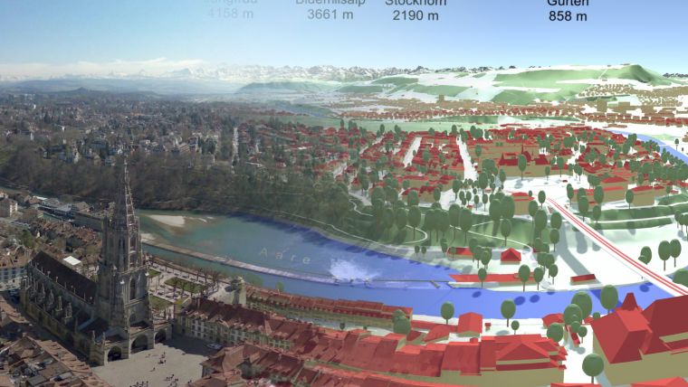
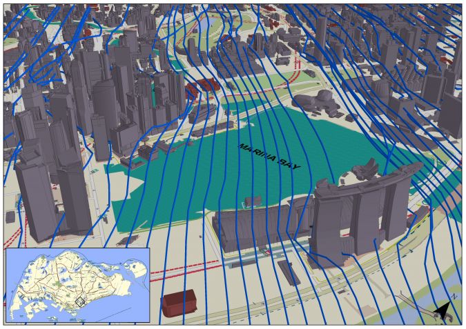
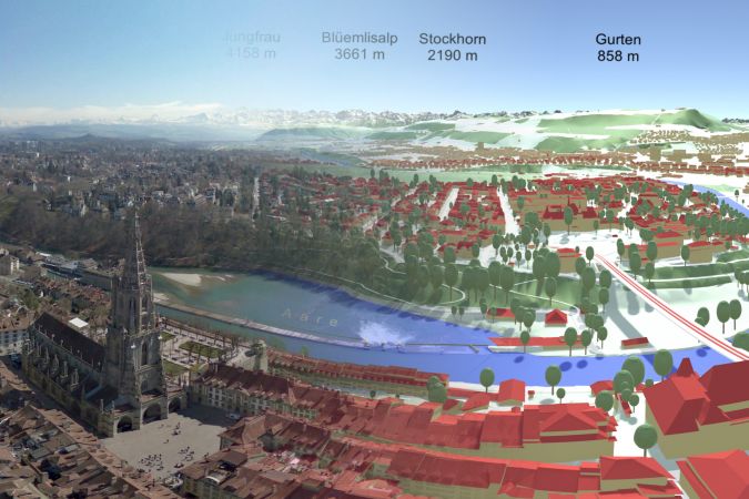
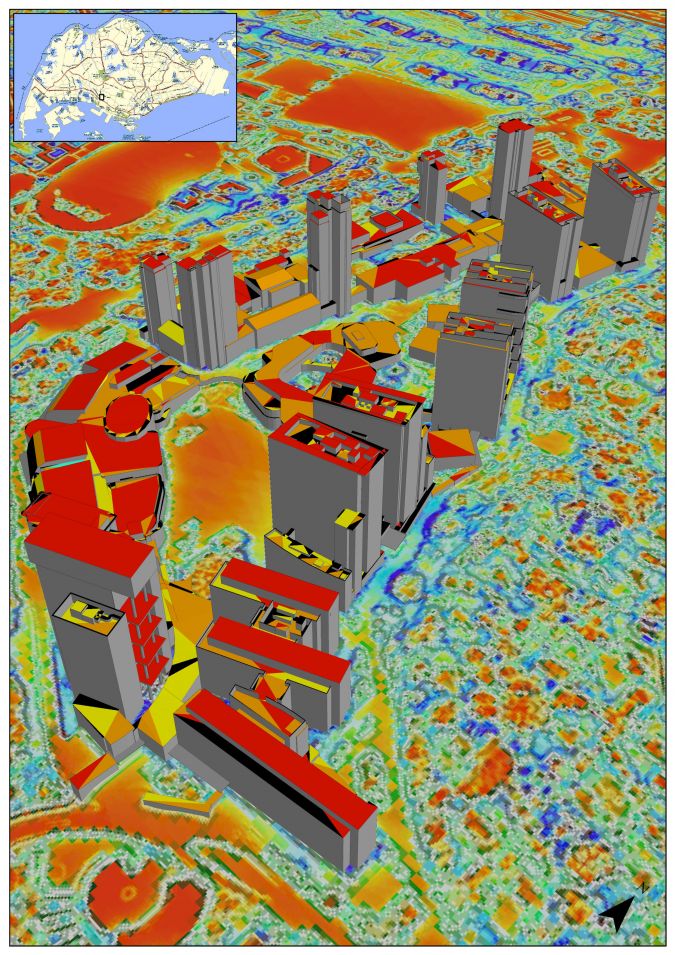
This has echoes of an earlier time, when digital mapping and GIS found their way from the American defence industry to the national mapping authorities worldwide. There were not many convincing cost-benefit studies proving GIS was profitable, yet the PMAs still had to make the switch because everybody could see that it made so many processes more effective and the technology was here to stay. Stoter and Crompvoets recognise many similarities. They add: “An important difference is that back then the transition was made easy because the initial costs of the national large-scale digital mapping and GIS revolution had largely been paid by the utilities sector. Now the demand is so fragmented that there is no focus for a shared business model.” Also, compared to the analogue way of working until then, GIS was a really disruptive technology; the market understood that serious investments and national coordination were needed. “But we passed the point of no return for the transition to 3D about five years ago,” states Jantien Stoter. “Since we can’t calculate the profit of new technology for new and currently unknown possibilities, we have to stop concentrating on the doubts. Look at examples such as Singapore and large cities in China or the PMA of Switzerland – they made the complete switch to 3D geoinformation and no longer want to be without it.” Joep Crompvoets outlines the plans for future research: “Our investigations will concentrate on how – and not whether – to make the change. We think that mapping of base data in 3D is the most efficient for a country when it is centralised, harmonised and quality controlled by the national mapping agencies. Which steps can be taken? Which priorities work best? And how should it be financed?”. His colleague concludes: “It is about the production of correct, up-to-date 3D data at different levels of detail for different applications, without every user group producing and paying for its own snapshot of reality. We’d better get going – back to the future!”
EuroSDR
EuroSDR is a not-for-profit organisation linking national mapping and cadastral agencies with research institutes and universities in Europe for the purpose of applied research in spatial data provision, management and delivery. Joep Crompvoets is EuroSDR’s secretary-general and chairs the Business Models and Operation Commission. He is a professor of information management in the public sector, senior researcher/consultant and project manager at the Public Governance Institute of KU Leuven, Belgium. Jantien Stoter leads the EuroSDR 3D Special Interest Group. She is a professor of 3D geoinformation at The Netherlands’ TU Delft, Faculty of the Built Environment & Architecture. Prof Stoter also works as an innovation researcher at both Kadaster and Geonovum.

Value staying current with geomatics?
Stay on the map with our expertly curated newsletters.
We provide educational insights, industry updates, and inspiring stories to help you learn, grow, and reach your full potential in your field. Don't miss out - subscribe today and ensure you're always informed, educated, and inspired.
Choose your newsletter(s)


