Time Team Unveils Fortress Jersey’s Past
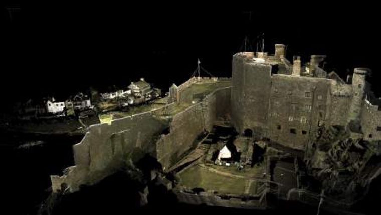
Sophisticated 3D laser scanning technology has been used by a UK TV Channel 4 to create high-definition fly-though animations to map development of advanced fortifications around Mont Orgueil Castle in Jersey. A survey team from Digital Surveys captured hundreds of millions of millimetre-accurate measurements for Channel 4's flagship programme Time Team, which has been uncovering the archaeological mysteries of the British Isles since 1994.
Processed using Pointools software, the survey team was able to create a series of high impact 3D images complete with advanced lighting effects which featured in the final broadcast.
Ben Bennett, director of Digital Surveys, said that initially the producers thought the 3D laser scanner would only be used to record measurements to help the team make decisions, explain their discoveries and support any conclusions they may come to. “That’s because they had already employed their own 3D modeller to recreate the castle. However, after viewing the point-cloud model captured during the first day’s survey work, the team agreed that its visual quality and clarity was far superior to the manual modelling efforts. As a result, the visualisations and animations created using Pointools software were used instead, greatly enhancing the show’s visual appeal.”
Due to a tight production schedule Digital Surveys was given just three days on site to measure the whole castle. Just as the challenging topography posed difficulties to would be attackers centuries ago, it also created technical challenges for the survey team. Using a Leica Scanstation 2 scanner, eighteen 360 degree scans were completed to record the external defensive walls (the Upper Grand Battery), the internal middle wall, the keep roof and internal rooms. Afterwards, the data was cleaned to remove noise before being imported into the Pointools software.
Time Team Director and owner Tim Taylor also was satisfied with the results and he is looking forward to using 3D laser scanning technology on the show again.

Value staying current with geomatics?
Stay on the map with our expertly curated newsletters.
We provide educational insights, industry updates, and inspiring stories to help you learn, grow, and reach your full potential in your field. Don't miss out - subscribe today and ensure you're always informed, educated, and inspired.
Choose your newsletter(s)


