Transforming the collection of high-precision geodetic monitoring data
A cost-effective, labour-saving and carbon-neutral solution
The Locator One solution for autonomous GNSS-based precision measuring has been sold and leased to numerous construction and infrastructure companies, both in the Netherlands and internationally. It was jointly developed by a company specialized in the collection and analysis of surveying data and images, and a provider of Internet of Things (IoT) solutions for tracking and sensing. Bundling their individual specialties and market knowledge resulted in the creation of Basetime, an innovative start-up, in 2021.
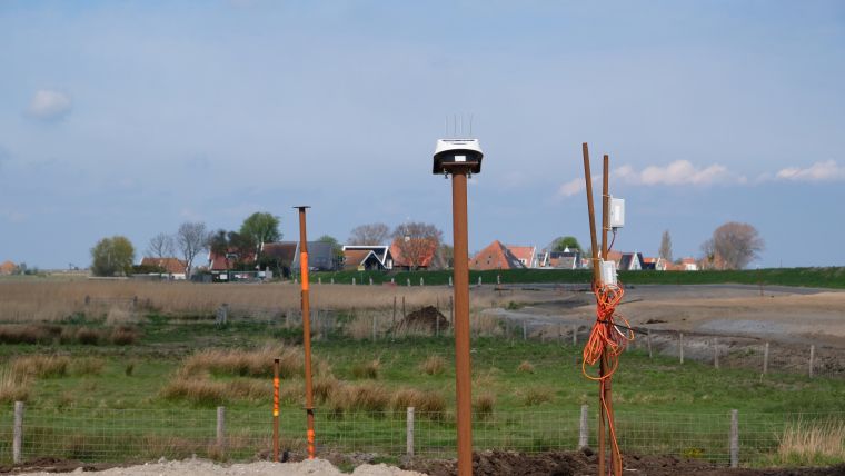
Small movements in objects or terrain may seem harmless, but in the case of too much movement (also known as ‘deformation’ for assets and ‘settlement’ for ground), the function of an object may be compromised. In the worst case – such as bridges that can no longer be closed, or landslides – it could even lead to catastrophes. That is why the demand for accurate data about object and terrain movements is increasing. For higher safety and to be able to understand deformation and settlement, very accurate movement data is needed. Basetime took on the task to revolutionize the collection of high-precision geodetic data, resulting in the development of a high-quality and reliable autonomous 3D monitoring station called the Locator One.
3D subcentimetre monitoring precision
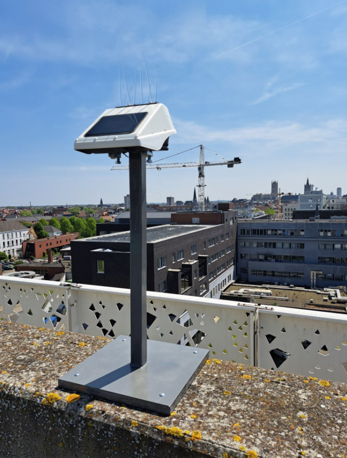
The Locator One is the first device developed by Basetime. It is intended for autonomous GNSS-based precision measuring. The device was developed for construction companies, surveyors, maritime corporations, geotechnical and structure engineers, and asset managers with complex motion monitoring tasks. It can be mounted to an asset, or a settlement rod in case of ground monitoring, to achieve 3D subcentimetre monitoring precision.
The Locator One includes GNSS, accelerometer, thermometer and radar sensors to monitor every 2D or 3D movement of an asset or terrain with precision to within 5mm in height (Z) and 3mm horizontally (XY). Poor or incomplete data is automatically filtered out by the algorithm, typically resulting in 95% data reliability. Moreover, all movements and positions can be delivered in 3D absolute coordinates, in any local coordinate system.
Endless applications
Originally, the Locator One was only used for settlement monitoring by mounting it on to a settlement rod. Large construction and dredging companies were among the first to use the solution for monitoring newly constructed sites, roads, dikes, dredging grounds, earthwork stockpiles and construction sites. But the device can also be mounted to an asset, such as a building or a bridge, and the possibilities are endless. Surveyors and asset managers now also use the Locator One for monitoring buildings and instable land masses, such as mountains and soil erosion. Other examples of applications include the monitoring of retaining walls, water levels, landslides and open mines. In fact, the device is even versatile enough to be used in case of earthquakes.
Data at your fingertips
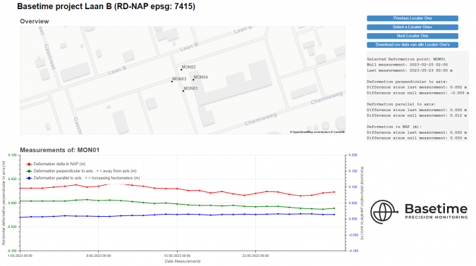
The measurements take place at predefined timestamps, ranging from once a day to once an hour – or even more frequently if necessary. The devices send their observations and metadata to the Basetime cloud through an IoT network. After several geodetic adjustments and calculations, the data is delivered. The results are displayed on the Basetime dashboard or in another preferred environment through an API. This makes it possible for geospatial professionals to analyse all the information from behind their desk or on a mobile device in line with client’s preferred working method.
A sustainable and cost-effective solution
The Locator One functions without batteries and is carbon neutral during use. Since this approach means that very few surveyors are needed to conduct ground settlement measurements, the solution increases construction-site safety. It also maximizes the availability and cost-effectiveness of surveyors by allowing them to be deployed for more high-value activities.
In addition to the above-mentioned sustainability, automation and labour-saving benefits, the Locator One provides very reliable data. The combination of precise measurements at a predefined time increases the foundation for making reliable predictions of settlement behaviour. As a result, the geospatial engineer gains a clear view of the stabilization period much sooner and the embankments can be placed more precisely and therefore often earlier, thus saving valuable construction time. Multiple Basetime projects have demonstrated that this accelerates projects for earlier delivery, which significantly contributes to the project result and also directly to emissions savings. Last but not least, the Locator One is very easy to install and use and very affordable, whether purchased or rented.
Changing the game of monitoring
As a joint venture of a leading IoT developing company and an expert geodetic services provider, Basetime aims to change the game of monitoring by creating the best of both worlds. The company name is a combination of ‘baseline’ plus ‘time’: the two ingredients needed to obtain accurate GNSS measurements at the necessary timestamps. The Dutch-based start-up offers a full-stack solution including device, database, dashboard and ongoing support and services.
Expanding the dealer network
The first dealer to sign up with Basetime was Boels in the Netherlands – one of Europe’s biggest rental companies for machines and tools – with a special focus on the lease and rent of the Locator One devices. Since then, the company has also appointed dealers in Germany and Belgium, and is in advanced discussions with numerous professional partners globally. Having recently attracted substantial funding, Basetime is now rapidly expanding its global dealer network as the next step on its path to realizing its ambitions. “Accelerated product and services development as well as more focus on international expansion through dealers and partners will allow us to address and serve our customers much better and reach new markets globally,” states CEO Martijn Arkesteijn. “We are still looking for companies to join our dealer network. With a strong network of local dealers, we aim to put all the necessary high-precision geodetic monitoring data within reach for all professionals worldwide,” he concludes.

Value staying current with geomatics?
Stay on the map with our expertly curated newsletters.
We provide educational insights, industry updates, and inspiring stories to help you learn, grow, and reach your full potential in your field. Don't miss out - subscribe today and ensure you're always informed, educated, and inspired.
Choose your newsletter(s)


