Altus Launches Second-generation GNSS RTK Rover
Altus Positioning Systems has announced the introduction of its new APS-NR2 RTK surveying receiver. The new product, which was previewed at the 2014 Geo Business conference and exhibition in London on 28-29 May, will be commercially available in July.
The APS-NR2 provides a powerful combination of high GNSS RTK performance, light weight, low power consumption, versatile Quad-band modem, remote web-based access and connectivity with Esri’s cloud-based platform, said Neil Vancans, Altus president and CEO. The result is a versatile product designed to enhance productivity and minimise downtime in the field for a wide range of surveying and geolocation jobs, he added.
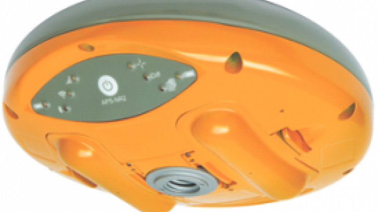
The surveying receiver is Altus’ second-generation RTK rover, building on the APS-3 product series. It features an on-board web interface and integrated Wi-Fi for remote configuration and status monitoring, as well as Bluetooth for real-time data streaming, providing cable-free operation. In parallel to RTK positioning, data can be recorded on a removable 2GB SD memory card for post-processing.
GPS and GLONASS
The APS-NR2 is built around a low-power 132-channel GPS/GLONASS L1/L2/L2C SBAS receiver, aiming to offer robust RTK performance, as well as DGPS capability. The internal 3.5G Quad-band GSM/GPRS/EDGE cellular modem supports RTK network connectivity. Dual internal cellular antennae ensure a positive signal lock and minimise disruptions due to dropped calls.
The new Altus receiver comes with two Li-Ion batteries. It has a built-in USB battery charger, as well as a separate two-bay external charger. The batteries are hot-swappable, allowing uninterrupted productivity on the job. With Altus’ open-architecture philosophy, the user has a choice of data collector software from Carlson SurvCE, MicroSurvey FIELDGenius or direct interface to Esri ArcGIS Online, as well as proprietary customer-developed software.
The APS-NR2 does not sacrifice essential processing power or connectivity and still weighs 0.7kg (1.5lbs). The compact receiver is 69mm (2.7in) high and 167mm (6.6in) in diameter. The rugged unit is waterproof to IP67 and has an operating temperature range of -40 to +85°C.

Value staying current with geomatics?
Stay on the map with our expertly curated newsletters.
We provide educational insights, industry updates, and inspiring stories to help you learn, grow, and reach your full potential in your field. Don't miss out - subscribe today and ensure you're always informed, educated, and inspired.
Choose your newsletter(s)


