ArcGIS Pro Certified for 3D PluraView Monitor Visualization
Schneider Digital has officially certified the compatibility of Esri's ArcGIS Pro software with the entire 3D PluraView monitor product family.
ArcGIS Pro integrates important functionalities from photogrammetry, such as importing aerial images, aero-triangulation, and extraction of terrain models, orthorectification and stereoscopic data capture. This ensures a continuous GIS workflow - including photogrammetric data capture - directly in the Esri environment, resulting in substantial efficiency gains. The central element here is the complete integration of all existing and newly captured three-dimensional geometries with ArcGIS Pro, and the integrated ability to represent them with full three-dimensionality on stereoscopic output devices. The software can efficiently display and process GIS, BIM, Lidar and photogrammetric geodata in a fully integrated 3D-stereo work environment.
Whether for professional thematic maps, complex GIS analysis, geodata management or GIS data capture, GIS professionals have a whole range of interactive and automated tools at their fingertips with the 3D-capable software application ArcGIS Pro from Esri, including for optimal geodata querying and processing, and the capture and analysis of spatially connected and topologically correct features. Locally saved geoinformation in 2D and 3D format can for example be compared to or synchronized with cloud servers and online data services. Topographic terrain features and building models at different levels of detail (LOD) can likewise be extracted and saved to file geodatabases (GDB). ArcGIS Pro also offers a range of tools for the management, editing and analysis of large amounts of data, e.g. large-format aerial images, UAS and satellite images, and Lidar point-cloud data. Real façade textures can be mapped to 3D building geometries from oblique aerial images and vehicle-based mobile camera systems. Likewise, hybrid 3D terrain models can be generated from orthoimages, combined with synthetic 3D models for vegetation and building objects.
Large data volumes and super-high resolution
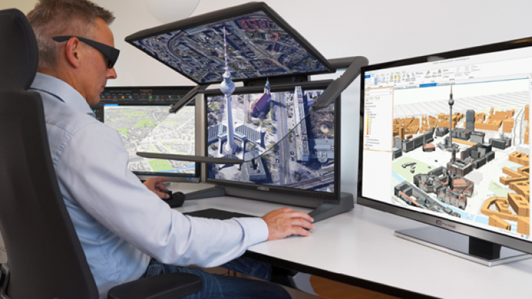
The prerequisite for the optimal stereoscopic display of 3D geodata is a monitor system with high-resolution, bright and contrast-rich 3D stereoscopic visualization. This advanced visualization solution is provided by the 3D PluraView family of monitors by Schneider Digital, which are latency-free and work ‘plug-and-play’ with professional NVIDIA and AMD graphics cards. As there is no requirement for proprietary graphic drivers, the 3D PluraView displays are a future-proof solution to display geospatial data also with future versions of LINUX and Microsoft operating systems. The extremely large data volumes, which ArcGIS Pro can process, require not only a professional graphics card and a professional workstation, but also a monitor, which can display topographical information and GIS content in 3D stereo quality.
Schneider Digital's 3D PluraView passive, dual-screen, 3D-stereo beam-splitter monitors have been the de-facto industry standard for all stereoscopic software applications for the past 16 years and are certified for all common 3D stereo-capable photogrammetry and GIS applications. The fold-up beam-splitter mirror allows the flexible use of the 3D PluraView monitors also as a standard monitor for monoscopic tasks. With screen diagonals up to 28”, 3D PluraView monitors provide completely flicker-free stereoscopic 3D visualizations. Thanks to one screen per stereo channel, they offer the full stereo resolution up to 4K (UHD) and 10-bit colour depth with brilliant brightness. Their passive polarization filter technology provides a fatigue-free ergonomic working environment, even in office daylight conditions.
Visualize, capture and edit GIS and BIM models in stereo
ArcGIS Pro users value the accurate, pixel-precise, stereoscopic image display on Schneider Digital’s 3D-stereo monitors. The high level of viewing comfort on the flicker-free displays and the intuitive operation facilitate the handling of complex data visualizations, thereby improving overall productivity and accelerating working procedures. In combination with ArcGIS Pro, the technology of 3D PluraView monitors offers the possibility of uploading aerial image stereo pairs to capture 3D points, lines or polygons directly as topologically defined GIS elements. 3D mesh-based geometries, smart BIM models and even 3D CAD models can be edited intuitively in a fully integrated 3D-stereo environment.
ArcGIS Pro users benefit from compatibility with a wide variety of data formats when importing and integrating smart 3D models into existing GIS datasets. For subsequent visualization, the 3DConnexion SpaceMouse is a well-proven device, allowing simple and intuitive 3D navigation within ArcGIS Pro. The additional use of a Stealth 3D mouse is recommended where the focus is on the precise measurement and capture of objects, elevations and distances. One of the biggest challenges for GIS applications is the loading of large amounts of data (e.g. detailed urban models) as digital twins, and then displaying them seamlessly in stereo. This requires reliable photogrammetry and GIS solutions, which are innovative, ergonomic, fast and reliable. The stereo-capable software application ArcGIS Pro and the 3D PluraView monitors by Schneider Digital provide this reliability through the synergy of two high-end products. The ArcGIS Pro software from Esri meets all requirements for efficient stereoscopic working with geospatial 3D datasets and has now been certified officially for compatibility with the entire 3D PluraView monitor product family by Schneider Digital. This ‘duo’ turns into the perfect workplace solution with the right 3D input tools and a high-performance Schneider Digital workstation, customized for use with ArcGIS Pro.
Find out more at www.pluraview.com

Value staying current with geomatics?
Stay on the map with our expertly curated newsletters.
We provide educational insights, industry updates, and inspiring stories to help you learn, grow, and reach your full potential in your field. Don't miss out - subscribe today and ensure you're always informed, educated, and inspired.
Choose your newsletter(s)


