Automatic Analysis and Mapping of Road Geometry
Dutch company GeoSignum has developed innovative methodologies for analysing and mapping road geometry in an automated manner. With these methodologies, changes in the existing road alignment geometry, road curvature and cross slopes can be automatically calculated and mapped based on a critical level. After extracting the related road segments from raw mobile laser datasets, the software automatically codes the geometrical information: yellow for acceptable and red for areas requiring attention.
For instance, if a road curvature and related design parameters have changed in time or there have been calculation mistakes in the initial road design procedure of the road curve, the developed technology identifies the road’s curvatures and classifies the related road curve which can be compared to the original design parameters. The obtained curvature results can also be used in navigation systems to give a recommended speed to the driver to safely navigate the bend.
Large road segments can be easily visualised on Google earth for quick inspections based on the yellow and red coded vectors. This way, hundreds of thousands of kms of road can be inspected in an extremely short period of time and at low cost. In addition, road surfaces and road edge-lines can beautomatically extracted in a very short time for further analysis or to make a new engineering design.
Systematic monitoring of hazardous conditions or sudden geometric changes of highways or road sections is an essential step to improve the safety and comfort of drivers, said Dogan Altundag, founder of GeoSignum.
Despite the fact that mobile laser scanning technology has been used for over a decade in 3D road mapping and related surveying fields, automatic feature extraction, analysis and 3D mapping using the mobile laser datasets still needs extensive development.
GeoSignum develops solutions to improve the techniques with a unique method that reduces human error. GeoSignum solutions are automated, accurate and fast, saving costs for those applying it.
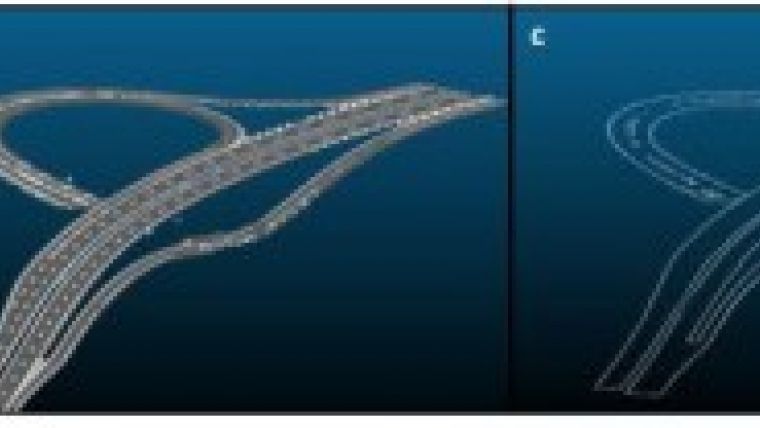
The figure shows fully automated road geometry analysis and mapping, a) raw MMS data, b) automatically extracted road surface, c) automatically extracted road edges, d) automatically calculated and mapped road curvature.

Value staying current with geomatics?
Stay on the map with our expertly curated newsletters.
We provide educational insights, industry updates, and inspiring stories to help you learn, grow, and reach your full potential in your field. Don't miss out - subscribe today and ensure you're always informed, educated, and inspired.
Choose your newsletter(s)


