Catsurveys Introduces Rapid Vehicle-based MGPR Innovation
This article was originally published in Geomatics World.
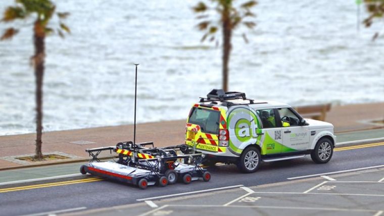
New mobile ground-penetrating radar (MGPR) from Catsurveys Group is challenging traditional approaches to utilities and other subsurface surveying. Catsurveys’ MGPR is a georeferencing system and synchronisation process enabling data generated using a vehicle-towed MGPR system to be combined with a global positioning system (GPS) for maximum accuracy and detail.
The International Society for Trenchless Technology's (ISTT) award-winning MGPR system is developed to be a key component for feasibly studies and civil engineering projects, providing a vision of where to carry out intrusive works, letting the user make the best informed decision possible before breaking any ground, reducing risks, costs and time. It provides fast data collection with minimal traffic management, and aims to lower health and safety risks for survey staff.
50 linear kilometres
The rapid data collection system provides several interesting benefits. For example, it can record up to 50 linear kilometres a day to identify underground carriageway utilities, apparatus, structures, buried manholes, covers, chambers, culverts, tunnels, and unrecorded underground infrastructure to confirm clear route space. This eliminates unnecessary intrusive works – digging up road surfaces to find out what lies beneath the surface, for example.
The MGPR uses a multitude of low and intermediate frequency antennas to boost the quality of data and its reliability. According to Catsurveys, double polarised antennas cover both longitudinal and transverse scans to create one of the clearest underground images available. The surveys are accurate, combining GPS and total station theodolite recording to give pinpoint geolocations of all features of interest. This allows design based on facts and assists with building information modelling integration and clash detection (allowing for the effective identification, inspection and reporting of interferences in a 3D project model).
Customers that have benefited from the system include Balfour Beatty Construction Services UK (BBCSUK), which tasked Catsurveys to identify utilities and underground anomalies during the Dartford Freeflow Charging project to reduce traffic congestion, and Manchester Smart Motorways (MSM), which used the MGPR system to locate and identify all services crossing the busy M62 motorway.

Value staying current with geomatics?
Stay on the map with our expertly curated newsletters.
We provide educational insights, industry updates, and inspiring stories to help you learn, grow, and reach your full potential in your field. Don't miss out - subscribe today and ensure you're always informed, educated, and inspired.
Choose your newsletter(s)


