Cyclomedia Creates Digital 3D World of the Netherlands
By creating a digital 3D world based on a combination of aerial images and aerial point clouds, Cyclomedia has taken the next step to digitally visualize the Netherlands. Cyclomedia is a specialist in large-scale visualizations of the physical environment.
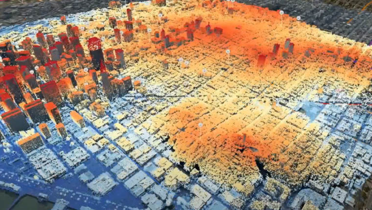
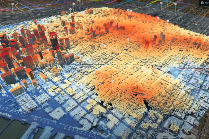
Called 3DNL, the geometrically accurate three-dimensional model of the entire Netherlands provides access to a true-to-life digital representation of reality, including a uniform 3D image, to scale, of the entire outdoor space. For governments and companies, 3DNL is a rich source of information for numerous day-to-day applications.
HxDR – Hexagon’s cloud-based visualization and collaboration platform for geographic data and services – is used to unlock the data within 3DNL. HxDR offers a range of standard functions and features that are an integral part of 3DNL and can be integrated into Cyclomedia’s Street Smart web viewer.
Data layers and 3D models
Thanks to the various features built into the online viewer, 3DNL serves a number of important uses, such as the ability to visualize data layers in the viewer. The link to PDOK (‘Publieke Dienstverlening Op de Kaart’, which is the platform for unlocking Dutch governmental geodatasets) allows users to stream open data into 3DNL in order to visualize additional, valuable data. These geodatasets are up-to-date and reliable sources for the public sector and private sector alike.
Other 3D models can also be displayed in the viewer. For scenarios in new construction projects, for example, it is possible to import 3D models (e.g. from CAD and BIM) into 3DNL and accurately align them in the right position. This enables the creation of true-to-life visualizations of future situations.
Applications
The geometrically correct 3D models can be used as a canvas for numerous daily activities, from situational analysis to asset management, and from a tool for permit checks to a comprehensive image database for city marketing. Just some of the applications are outlined below.
Citizen participation: the ‘fly-to’ function enables the development of videos for use in informative meetings or when presenting construction plans to the general public.
Simulations: perform sun and shadow analysis as the basis for solar capacity calculations and high-rise plans.
Asset management: 3DNL provides the correct contextual relationship between the current state of an object and its location as the basis for viewing and assessing a wide range of objects in the public domain.

Value staying current with geomatics?
Stay on the map with our expertly curated newsletters.
We provide educational insights, industry updates, and inspiring stories to help you learn, grow, and reach your full potential in your field. Don't miss out - subscribe today and ensure you're always informed, educated, and inspired.
Choose your newsletter(s)


