Ecopia and Airbus Expand 3D Vector Mapping Partnership
Ecopia AI is expanding its partnership with Airbus, pairing Ecopia’s large-scale 3D vector mapping technology with Airbus’ global satellite imaging capability. This partnership will enable the creation of a high-precision three-dimensional vector representation of the real world, created and maintained with unprecedented speed. As part of this expanded relationship, Ecopia will also be joining Airbus’ certified reseller network – further providing the ability for Ecopia to resell Airbus imagery as part of its product suite.
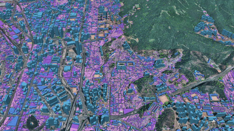
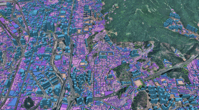
Through this continued partnership, Ecopia will leverage Airbus’ global very high-resolution 30cm imagery from Pléiades Neo and 50cm imagery from Pléiades, which will serve as an input for Ecopia’s AI-based 3D mapping systems. These 3D maps will offer a digital foundation for applications across sectors including government, insurance, telecommunications and consumer applications.
Monitoring Land Cover Evolution
Ecopia has begun large-scale map production under this partnership, having completed 3D vector mapping of buildings and vegetation across two countries covering more than 14 million buildings over 136,000km2 in support of a client initiative – an effort completed in just three weeks.
“We’re happy to provide our very high-resolution imagery to support Ecopia’s global 3D mapping capability,” said Francois Lombard, director of intelligence business at Airbus Defence and Space. “The 30cm resolution and geolocation accuracy of Pléiades Neo, combined with Ecopia’s AI-based systems, offers the perfect assets for precise and detailed mapping, while the high-revisit frequency of the satellites is ideal to monitor land cover evolution and keep any 3D databases up-to-date."
“We are very excited to announce this expansion of the Ecopia-Airbus partnership,” said Abigail Coholic, senior director of channel partnerships at Ecopia AI. “This relationship not only empowers Ecopia’s capability of delivering high-precision 3D vector maps at a global scale but also represents a step towards our vision of creating a digital twin of the Earth in collaboration with our partners.”
To view Ecopia’s HD Map samples, click here.

Value staying current with geomatics?
Stay on the map with our expertly curated newsletters.
We provide educational insights, industry updates, and inspiring stories to help you learn, grow, and reach your full potential in your field. Don't miss out - subscribe today and ensure you're always informed, educated, and inspired.
Choose your newsletter(s)


