Endangered Peruvian fortress secured by modern mapping methods
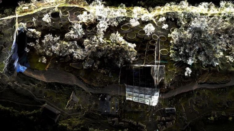
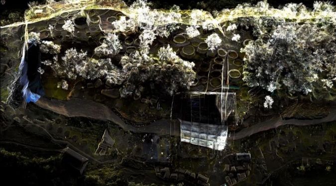
A RIEGL VZ-400i 3D terrestrial laser scanner was deployed in Peru to create a high-resolution digital 3D terrain model of an ancient fortress. This is a good example of how advanced Lidar technology forms a sound basis for the virtual preservation of cultural heritage monuments for future generations.
Kuélap is one of the largest ancient monuments in the Americas – and one of the most endangered. In spring 2022, the roughly 1,000-year-old fortification in northern Peru suffered massive damage from heavy rains in the Amazon. On the initiative of UNESCO and the Peruvian Ministry of Culture, the Ludwig Boltzmann Institute for Archaeological Prospection and Virtual Archaeology (LBI ArchPro), together with an international research consortium, documented this impressive cultural monument using RIEGL’s latest laser scanning technology and created a basis for future monitoring strategies and virtual preservation of the monument.
Collapse of fortress enclosing walls
The fortress of Kuélap sits picturesquely 3,000m above sea level on a ridge of the Andes in northern Peru. It was the political centre of the Chachapoya, a pre-Columbian culture that existed from about 900 to 1400 AD. In its heyday, the city originally covered 15 hectares and may have had as many as 300,000 inhabitants living in hundreds of round stone houses. The imposing enclosing wall was up to 20 metres high and was made of large limestone blocks. Kuélap has long been a major tourist attraction in Peru, and since 2019 it has been on the proposal list for inclusion as a UNESCO World Heritage Site, along with the Chachapoyas sites in Peru's Utcubamba Valley.
In the spring of 2022, Kuélap suffered massive damage from heavy rains in the Amazon, which led to the collapse of parts of the fortress's enclosing wall and its closure to the public. The acute threat to the cultural heritage prompted UNESCO and the Peruvian Ministry of Culture to immediately contact the LBI ArchPro research team, whose expertise in the efficient digital documentation of cultural monuments had already gained international renown through several archaeological prospection projects such as at Stonehenge (UK), Carnuntum (Austria) and Birka (Sweden).
Laser scanning and image-based modelling
At the end of September 2022, LBI ArchPro experts Matthias Kucera and Gerhard Stüttler travelled to Peru to record the site in three dimensions using various remote sensing methods during a two-week field mission. They met the challenge of very steep and difficult to access terrain with the combined use of terrestrial and airborne methods, which enabled the complete documentation of the fortress: terrestrial laser scanning (TLS), drone-based laser scanning (ALS) and image-based modelling. RIEGL supported the project with the latest Austrian technology in the form of a high-performance laser scanner. In the subsequent integrated analysis of the various datasets, the research team created a high-resolution digital 3D terrain model of the entire fortress of Kuélap, in which the more than 500 round stone houses, the enclosing wall and numerous other structures that are still visible on the surface were recorded with centimetre precision.
The investigations in Kuelap attracted a great deal of attention from national and international heritage management and conservation institutions. Peruvian Minister of Culture Betssy Betzabet Chavez Chino, as well as delegates from UNESCO and the World Monuments Fund (WMF), which had placed Kuelap on its watch list in 2004 due to its continued deterioration, visited the site during LBI ArchPro's research and personally saw for themselves that current actions are guiding further decisions on sustainable monitoring strategies for the endangered heritage site and providing a foundation for virtual conservation and accessibility for future generations.
In this video, the Ludwig Boltzmann Institute for Archaeological Prospection and Virtual Archaeology documents the work with the RIEGL VZ-400i 3D terrestrial laser scanner in Peru.

Value staying current with geomatics?
Stay on the map with our expertly curated newsletters.
We provide educational insights, industry updates, and inspiring stories to help you learn, grow, and reach your full potential in your field. Don't miss out - subscribe today and ensure you're always informed, educated, and inspired.
Choose your newsletter(s)


