Fugro to Develop Digital Twin of Denmark's Transmission Network
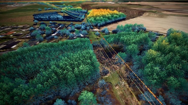
Denmark's Energinet has awarded Fugro a 5-year framework agreement to capture aerial Lidar and imagery data of the 3,000-line km electricity transmission network. The acquired geospatial data will be processed through Fugro’s Roames technology to develop a 3D digital twin of the network to report on critical clearances. As part of the framework, Fugro will partner with Energinet to develop a vegetation growth model to assist future vegetation and asset management programmes. Energinet is the Danish national transmission system operator.
Hybrid Aerial Mapping
Fugro is set to employ a lightweight helicopter equipped with scanning technology – including digital cameras and a Lidar system – to collect high accuracy geodata of Energinet’s network. The data will then be processed and analyzed using the Fugro Roames technology, which combines innovative 3D mapping techniques with advanced machine learning and cloud computing. The technology, designed specifically for power utilities, will create a digital twin and detailed analytics for remote asset inspection, identification, and condition assessment to help Energinet optimize their maintenance schedules and identify compliance defects.
Improved Accuracy of Vegetation Analytics
Fugro will also implement a dynamic network model to simulate the sag and swing of Energinet’s electrical conductors to significantly improve the accuracy of vegetation analytics. As part of the framework, Fugro will provide individual tree crown detection, as well as fall-in and critical tree risk identification. This initial analysis will lead to the development of a full-scale vegetation growth model allowing Energinet to proactively identify and prioritize risk for their whole network, conduct inspections through a web browser, and update and improve their data quality.
“This new framework agreement between Energinet and Fugro will provide valuable insights across our transmission network to support the maintenance of our infrastructure. Crucially, the vegetation data will help us to develop future vegetation management plans to minimize risks and build a sustainable solution for the future,” said Steffen Rosborg, Energinet’s project manager.
Bram Mulder, Fugro’s regional business line director of land asset Integrity, said: “Using Fugro Roames technology, asset engineers and network programme analysts can access and extract millions of records and asset attributes within seconds, optimizing Energinet’s maintenance schedules and improving the safety and reliability of their network. We’re proud to continue the development of digital inspection programs within the energy sector and look forward to working with Energinet over the next five years as we develop a full-scale vegetation growth model.”

Value staying current with geomatics?
Stay on the map with our expertly curated newsletters.
We provide educational insights, industry updates, and inspiring stories to help you learn, grow, and reach your full potential in your field. Don't miss out - subscribe today and ensure you're always informed, educated, and inspired.
Choose your newsletter(s)


