Geospatial Photo Filing
Geo Tactical Solutions, USA, is in the final stages of development for its new photo mapping and management software PhotoGIS. This solution will allow users to easily map, organise, export and manage images taken with GPS-enabled digital cameras while also providing capabilities designed to enhance and streamline the photo-capture workflow for various military, federal and commercial organisations.
One feature of PhotoGIS is its QR code generator for pre-field data collection. The user enters project or mission related information saved as ‘memos' and the software generates a QR code for the camera to scan. This ‘memo' information, once in the camera's memory, will then be attached to each recorded photograph. The ‘memos' attached to each digital image file are later used by the program to organise, display and populate standardised reports according to operation ID, photographer's name, operation type, and so on.
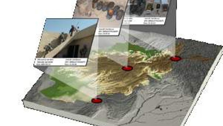
When photos are taken with a GPS-enabled camera, PhotoGIS will automatically plot the images in a map viewer based on their GPS coordinates. For images that do not contain spatial information, the user can manually drag an image to an approximate location on a map using satellite imagery as a reference. If images contain spatial information about objects within the photograph, the PhotoGIS map viewer will automatically plot the object and photographer (i.e. the camera) locations on the map. An arrow connects photographer location with object location showing the distance and direction from the photographer to the object. Object location can be obtained using one of GTS' G700SE-M or G700SE-f GPS-enabled digital cameras coupled with a laser range finder. For further geographic analysis, users can export image files into a variety of formats suitable for commonly used mapping applications such as Google Earth, ArcGIS and FalconView.
PhotoGIS also offers image mark-up and automated reporting capabilities. The user can drag and drop attribute information onto each image in addition to adding notes and simple vector graphics. After images have been imported and edited, the program can automatically populate report templates with the images, GPS location, Zulu date and time, ‘memos', and any additional notes about the photographs. Reports may be exported to Word, Power Point, PDF and other common document formats. All images and reports are stored in a relational database for maintaining data integrity and allowing for centralized sharing and collaboration.

Value staying current with geomatics?
Stay on the map with our expertly curated newsletters.
We provide educational insights, industry updates, and inspiring stories to help you learn, grow, and reach your full potential in your field. Don't miss out - subscribe today and ensure you're always informed, educated, and inspired.
Choose your newsletter(s)


