Hovermap Offers Powerful SLAM for Drone Autonomy and Lidar Mapping
This article was originally published in Geomatics World.
Hovermap is a UAV payload from DATA61 and CSIRO that brings advanced autonomy, SLAM-based mapping, omnidirectional collision avoidance, and GPS-denied flight to drones. Though Hovermap was designed for use in complex industrial applications in the mining and telecommunications industries, it can be used for any application where users want to collect previously unavailable data in a safe, repeatable, and efficient way.
Tech Specs
Currently in its beta testing configuration, the payload comprises a Velodyne VLP-16 Lite, a low-grade MEMS IMU and an embedded computer. The commercial release will add three cameras, PPK GPS and a long-range radio link for telemetry and real-time point cloud visualization. This commercial version will weigh 2kg.
The lidar is mounted to capture a spherical view meaning it gathers a lot of data on a single pass and requires fewer passes to map complex objects. The spherical view also offers the data needed for an obstacle avoidance system–all without adding an extra sensor.
If your drone-mapping system includes a compatible autopilot, you’ll gain access to advanced autonomy. When you use the Hovermap this way, Dr. Hrabar, who worked on the project, promises “application specific autonomy” and “single click mission execution” in complex and dangerous situations. Send the drone on its way, and receive a real-time point cloud as the mission progresses.
SLAM and Autonomy
Perhaps the most noteworthy feature of Hovermap is it uses SLAM technology to perform both autonomous navigation and mapping. Although this is rare, the developers were able to integrate these two functions so they work in cooperation.
Hovermap’s autonomy features help improve the SLAM results, and these SLAM results make for improved autonomy. How does that work? Dr. Hrabar explains that the best SLAM requires flying the UAV in a certain way (“for example, at the right speed, at a suitable distance from the features, and having a transect overlap to close the loop”). An autonomy system that accounts for these requirements can ensure that the flight path produces good SLAM results.
More Coming
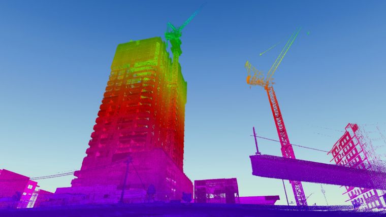
Though Hovermap is currently in beta testing, and not all the features are currently implemented, the benefits of the payload are already clear. Compared to terrestrial lidar, Hovermap scanning is much faster and enables mapping of much taller structures. As compared to drone-based photogrammetry, Hovermap offers faster processing time and they’ll soon be able to offer a live view of the point cloud and the potential for cleaner, better results.
Beyond that Hovermap could improve efficiencies in existing applications and even enable new ones. For example, the system enables a drone to perform fully autonomous mapping of mine stopes and other dangerous parts of a mine.
In fact, it can be used in any application where the drone needs complete autonomy to explore and map an area and find its way out safely, which would be very useful for mapping indoor stockpiles, warehouses and large liquid storage vessels. Only time will tell how the market uses this solution.
Though the technology is being developed under CSIRO at the moment, the team will be forming a new spin-out named Emesent Technologies to commercialize the technology. You can find more information at their website or YouTube channel.

Value staying current with geomatics?
Stay on the map with our expertly curated newsletters.
We provide educational insights, industry updates, and inspiring stories to help you learn, grow, and reach your full potential in your field. Don't miss out - subscribe today and ensure you're always informed, educated, and inspired.
Choose your newsletter(s)


