Insitu ScanEagle UAS Helps Suppress Wildfires
This article was originally published in Geomatics World.
Insitu, a wholly owned subsidiary of The Boeing Company, has been helping firefighters combat wildfires in Oregon, USA, providing information for fire suppression activities via its data collection, analysis and delivery capabilities. Comprised of aviation professionals, Insitu's Mobile Response Team has been operating its ScanEagle unmanned aerial system (UAS) to supplement manned aviation firefighting teams battling fires. ScanEagle is a licensed and approved UAS operating in full compliance with FAA regulations and with the full approval of local, state and federal fire authorities.
A UAS team working on a fire consists of a vendor flight crew, as well as federal personnel who work together to meet the incident goals and objectives. The UAS manager (a federal employee) provides the required communication between air and ground resources to facilitate safe and effective missions, while the Data Specialist (also a federal employee) works directly with the vendor flight crew and incident GIS Specialist (GISS) to ensure timely development/delivery of requested data products.
The ScanEagle teams "fly the gaps," meaning they fly the UAS at night and over dense smoke and inversion conditions, when manned aircraft typically are grounded due to hazardous conditions for pilots. The ScanEagle team to date has logged more than 200 hours of night flight time during nearly 30 flights.
Spotting heat signatures with sensors and cameras
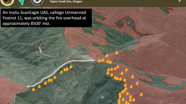
The payload onboard the ScanEagle includes infrared sensors and electro-optical cameras that gather and disseminate geospatial imagery, and provide incident perimeter maps and full motion video. The sensors and cameras spot heat signatures, fire movement and fires, and provide a video feed of critical infrastructure, historical buildings and other structures that might be in danger, as well as identifying safe ingress and egress routes for fire fighters.
"Above all, our main mission is to help combat these unrelenting fires and help keep the fire fighters, the residents and the communities safe," explained Andrew Duggan, vice president, Insitu Commercial. "One of the benefits of flying UAS over difficult and rugged terrain is mitigating the need for fire fighters to physically walk it when locating and extinguishing hot spots," he continued. "By flying UAS at night, fire incident commanders have the advantage of significant fire intelligence and heightened situational awareness for their early morning planning meetings in determining where to most effectively and safely dispatch their resources and personnel."
All ScanEagle UAS flights have been coordinated with the Oregon Department of Forestry (ODF), the Federal Aviation Agency (FAA) and the Department of the Interior (DOI).

Value staying current with geomatics?
Stay on the map with our expertly curated newsletters.
We provide educational insights, industry updates, and inspiring stories to help you learn, grow, and reach your full potential in your field. Don't miss out - subscribe today and ensure you're always informed, educated, and inspired.
Choose your newsletter(s)


